
Podolian Upland
(Redirected from
Podolian Plateau
)


The Podolian Upland (Podolian Plateau) or Podillia Upland (
highland area in southwestern Ukraine, on the left (northeast) bank of the Dniester River, with small portions in its western extent stretching into eastern Poland
.
The region lies roughly between the
Western Bug
also originating in the northwest of the highlands. The average altitude of the Podolian Upland is over 300 m (980 ft) with the maximum being a hill known as Kamula Mountain, at 471 m (1,545 ft).
The surface is characterized by a combination of wide flat interfluves and deep canyon-like valleys (so called dales) dissected into separate natural sub-regions:
- Wooded elevated hills
- Roztochia
- Holohory
- Voronyaky
- Kremenets Hills (Mountains)
- Tovtry Hills
- Flat treeless plateaus
- Ternopil Plateau
- Upper Bug Plateau
- North-Podolian Plateau
The Podolian Upland and the Volhynian Upland are sometimes grouped together as the Volhynian-Podolian Upland.
Gallery
-
 Podolian Tovtry
 -

-
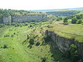 Smotrych Canyon (Tovtry)
 -
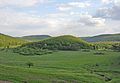 Great Hovda Hill


See also
External links
- Podolian Upland at the Encyclopedia of Ukraine.
- Herenchuk, K.I. Podolian Upland. Ukrainian Soviet Encyclopedia
- Shabliy, O.I., Mukha, B.P., Huryn, A.V., Zinkevych, M.V. Lviv Oblast relief. Podolian Upland (Рельєф Львівської області. Подільська височина). "Geography: Lviv Oblast".
49°01′39″N 27°51′22″E / 49.0275°N 27.8562°E
This article about a location in Ukraine is a stub. You can help Wikipedia by expanding it. |
This Poland location article is a stub. You can help Wikipedia by expanding it. |