
Punakha District
27°40′N 89°50′E / 27.667°N 89.833°E
Punakha district
སྤུ་ན་ཁ་རྫོང་ཁག | |
|---|---|
District | |
|
UTC+6 (BTT) | |
| HDI (2017) | 0.654[1] medium · 7th |
| Website | www |
Punakha District (
dzongkhags (districts) comprising Bhutan. It is bordered by Thimphu, Gasa, and Wangdue Phodrang Districts. The dominant language in the district is Dzongkha
, the national language.
Culture

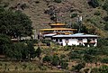
Shabdrung Ngawang Namgyal. The Punakha Dzong is one of the most historic dzongs in the whole country. Built by Shabdrung Ngawang Namgyal in the 17th century, it is located between the confluence of two rivers: Pho Chhu (male) and Mo Chhu
(female).
Administrative divisions
Punakha District is divided into eleven village blocks (or gewogs):[2]
Geography
Over half of Punakha District (the gewogs of
biological corridors along the Thimphu District border.[3]
See also
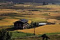
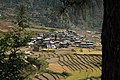
Gallery
- Punakha District
-
 Punakha
 -
 Dzong
Dzong -
 Lobesa
 -
 Sopsokha
 -
 Yowakha
 -
 Chime Lhakhang


References
- ^ "Sub-national HDI - Area Database - Global Data Lab". hdi.globaldatalab.org. Retrieved 2018-09-13.
- Government of Bhutan. 2011. Archived from the original(PDF) on 2011-10-02. Retrieved 2011-07-28.
- ^ "Parks of Bhutan". Bhutan Trust Fund for Environmental Conservation online. Bhutan Trust Fund. Archived from the original on 2011-07-02. Retrieved 2011-03-26.
| International | |
|---|---|
| National | |
This Bhutan location article is a stub. You can help Wikipedia by expanding it. |