Røros (town)
Røros | |
|---|---|
Gauldalen | |
| Municipality | Røros |
| Established as | |
| Bergstaden | 1646 |
| Area | |
| • Total | 3.19 km2 (1.23 sq mi) |
| Elevation | 620 m (2,030 ft) |
| Population (2018)[1] | |
| • Total | 3,865 |
| • Density | 1,212/km2 (3,140/sq mi) |
| Time zone | UTC+01:00 (CET) |
| • Summer (DST) | UTC+02:00 (CEST) |
| Postcode | 7374 Røros |
| Official name | Røros Mining Town and the Circumference |
| Criteria | Cultural: iii, iv, v |
| Reference | 55 |
| Inscription | 1980 (4th Session) |
| Extensions | 2010 |
| Area | 16,510 hectares (64 sq mi) |
| Buffer zone | 481,240 hectares (1,858 sq mi) |
Røros Municipality | |
| Administrative centre | Røros |
| Area (upon dissolution) | |
| • Total | 124 km2 (48 sq mi) |
| • Rank | #3063 in Norway |
| Demonym | Rørosing[3] |
| ISO 3166 code | NO-1640[4] |
Røros (
The
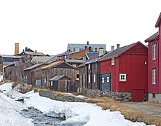
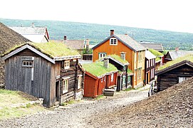
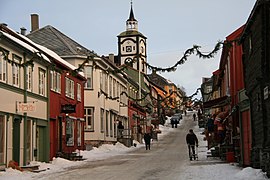
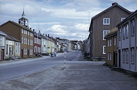
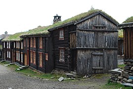
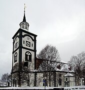
The modern-day inhabitants of Røros still work and live in the characteristic 17th- and 18th-century buildings which have led to its designation as a UNESCO World Heritage Site in 1980. Røros has about 80 wooden houses, most of them standing around courtyards. Many retain their dark pitch-log facades, giving the town a medieval appearance. There are also two churches in the town. The large and historic Røros Church and the relatively new, but unique-looking Røros Chapel.[6]
History
The Røros area has been used by the Southern
The town of Røros was burned to the ground in 1678 and 1679 by the Swedish Army during the Scanian War. In 1718, during the Great Northern War, the town was once again taken by the Swedish Army, led by General De la Barre, who made up the southern arm of the main Swedish Army under Carl Gustaf Armfeldt. De la Barre took the town and all their mined copper at gunpoint.
When King Carl XII was killed near Fredriksten on 30 November 1718, De la Barre retreated north to join the bulk of the army. However, this ended in tragedy, when over 3,000 rather unprepared soldiers perished in the harsh weather conditions in the mountains northwest of Røros.
Røros and its people were made famous to Norwegians at the turn of the 20th century by semi-fictional author Johan Falkberget, who told the story of the mining community from the perspective of the hard-tested miners at the bottom of the social ladder.
With its authentic wooden buildings, Røros was added to the
Røros copper works
In 1644, the general manager of the mine at Kongsberg gave permission to exploit one lode of copper in the mountains near Rauhaammaaren. Storvola and Gamle Storwartz became some of the company's most important mines. Nordgruve, another important mining area, was situated to the north east of the town of Røros.
Starting in 1740 and onwards, there was a period of greatness for the Røros Copper Works with several mines yielding well.
Municipal history
The mining town of Røros was established in 1646 by King
During the 1960s, there were many municipal mergers across Norway due to the work of the Schei Committee. On 1 January 1964, the four municipalities of Glåmos (population: 700), Brekken (population: 964), Røros landsogn (population: 482), and the mining town, Bergstaden Røros, (population: 3,063) were all reunited under the name Røros.[9][5]
Municipal council
During its time as an independent municipality from 1926 to 1964, the
| Party name (in Norwegian) | Number of representatives | |
|---|---|---|
| Labour Party (Arbeiderpartiet) | 10 | |
| Conservative Party (Høyre) | 2 | |
| Communist Party (Kommunistiske Parti) | 2 | |
| Christian Democratic Party (Kristelig Folkeparti) | 1 | |
| Liberal Party (Venstre) | 2 | |
| Total number of members: | 17 | |
| Party name (in Norwegian) | Number of representatives | |
|---|---|---|
| Labour Party (Arbeiderpartiet) | 10 | |
| Conservative Party (Høyre) | 2 | |
| Communist Party (Kommunistiske Parti) | 2 | |
| Christian Democratic Party (Kristelig Folkeparti) | 2 | |
| Liberal Party (Venstre) | 1 | |
| Total number of members: | 17 | |
| Party name (in Norwegian) | Number of representatives | |
|---|---|---|
| Labour Party (Arbeiderpartiet) | 9 | |
| Communist Party (Kommunistiske Parti) | 3 | |
| Liberal Party (Venstre) | 2 | |
| List of workers, fishermen, and small farmholders (Arbeidere, fiskere, småbrukere liste) | 1 | |
| Local List(s) (Lokale lister) | 1 | |
| Total number of members: | 16 | |
| Party name (in Norwegian) | Number of representatives | |
|---|---|---|
| Labour Party (Arbeiderpartiet) | 8 | |
| Communist Party (Kommunistiske Parti) | 3 | |
| Liberal Party (Venstre) | 5 | |
| Total number of members: | 16 | |
| Party name (in Norwegian) | Number of representatives | |
|---|---|---|
| Labour Party (Arbeiderpartiet) | 9 | |
| Communist Party (Kommunistiske Parti) | 3 | |
| Local List(s) (Lokale lister) | 4 | |
| Total number of members: | 16 | |
| Party name (in Norwegian) | Number of representatives | |
|---|---|---|
| Labour Party (Arbeiderpartiet) | 9 | |
| Communist Party (Kommunistiske Parti) | 2 | |
| Joint List(s) of Non-Socialist Parties (Borgerlige Felleslister) | 5 | |
| Total number of members: | 16 | |
| Note: Due to the German occupation of Norway during World War II, no elections were held for new municipal councils until after the war ended in 1945. | ||
Name
The town is named after the old Røros farm ("Røraas" around 1530), since the town was built on its ground. The first element is the river name
Culture
During winter, a traditional
The town of Røros was the filming location for Henrik Ibsen's play "A Doll's House", directed by Joseph Losey.[19]
Media gallery
References
- ^ a b c Statistisk sentralbyrå (1 January 2018). "Urban settlements. Population and area, by municipality".
- ^ "Røros (Trøndelag)". yr.no. Archived from the original on 16 January 2018. Retrieved 15 January 2018.
- ^ "Navn på steder og personer: Innbyggjarnamn" (in Norwegian). Språkrådet.
- Store norske leksikon (in Norwegian). Kunnskapsforlaget.
- ^ Store norske leksikon (in Norwegian). Kunnskapsforlaget. Retrieved 15 January 2018.
- ^ "Røros – the mining town". Hurtigruten.us. Archived from the original on 7 February 2011. Retrieved 28 February 2011.
- ^ "The People and the Farms". The Røros World Heritage Site. Archived from the original on 4 December 2020. Retrieved 16 January 2018.
- ^ "The Røros Copper Works". The Røros World Heritage Site.
- ^ Jukvam, Dag (1999). "Historisk oversikt over endringer i kommune- og fylkesinndelingen" (PDF) (in Norwegian). Statistisk sentralbyrå.
- ^ "Kommunevalgene og Ordførervalgene 1959" (PDF) (in Norwegian). Oslo: Statistisk sentralbyrå. 1960. Retrieved 20 April 2020.
- ^ "Kommunevalgene og Ordførervalgene 1955" (PDF) (in Norwegian). Oslo: Statistisk sentralbyrå. 1957. Retrieved 20 April 2020.
- ^ "Kommunevalgene og Ordførervalgene 1951" (PDF) (in Norwegian). Oslo: Statistisk sentralbyrå. 1952. Retrieved 20 April 2020.
- ^ "Kommunevalgene og Ordførervalgene 1947" (PDF) (in Norwegian). Oslo: Statistisk sentralbyrå. 1948. Retrieved 20 April 2020.
- ^ "Kommunevalgene og Ordførervalgene 1945" (PDF) (in Norwegian). Oslo: Statistisk sentralbyrå. 1947. Retrieved 20 April 2020.
- ^ "Kommunevalgene og Ordførervalgene 1937" (PDF) (in Norwegian). Oslo: Statistisk sentralbyrå. 1938. Retrieved 20 April 2020.
- ^ Rygh, Oluf (1901). Norske gaardnavne: Søndre Trondhjems amt (in Norwegian) (14 ed.). Kristiania, Norge: W. C. Fabritius & sønners bogtrikkeri. p. 199.
- ^ "Rørosmartnan". Retrieved 25 February 2011.
- ^ "Et historisk musikkteater på Røros" (in Norwegian). Retrieved 28 October 2008.
- ^ "A Doll's House IMDB". IMDb.


