
Ragged Top
| Ragged Top | |
|---|---|
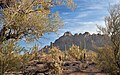
 Northeast aspect | |
| Highest point | |
| Elevation | 3,907 ft (1,191 m)[1] |
| Prominence | 1,347 ft (411 m)[1] |
| Parent peak | Silver Bell Benchmark[2] |
| Isolation | 2.40 mi (3.86 km)[2] |
| Coordinates | 32°26′58″N 111°29′24″W / 32.4495135°N 111.4901142°W[3] |
| Geography | |
 Ragged Top Location in Arizona  Ragged Top Ragged Top (the United States) | |
| Location | class 3 scrambling[2] |
Ragged Top is a 3,907-foot-elevation (1,191 m) mountain summit located within
ironwood forests cover the bajadas surrounding this mountain. This geographical feature lies within the Gila River drainage basin. Four small arches are located on this mountain.[6]
Climate
According to the
arid climate zone.[7]
| Climate data for Silver Bell Mountains | |||||||||||||
|---|---|---|---|---|---|---|---|---|---|---|---|---|---|
| Month | Jan | Feb | Mar | Apr | May | Jun | Jul | Aug | Sep | Oct | Nov | Dec | Year |
| Mean daily maximum °F (°C) | 63 (17) |
66 (19) |
71 (22) |
79 (26) |
88 (31) |
98 (37) |
98 (37) |
96 (36) |
93 (34) |
84 (29) |
72 (22) |
62 (17) |
81 (27) |
| Mean daily minimum °F (°C) | 43 (6) |
46 (8) |
49 (9) |
55 (13) |
63 (17) |
72 (22) |
74 (23) |
72 (22) |
70 (21) |
61 (16) |
51 (11) |
43 (6) |
58 (14) |
| Average precipitation inches (mm) | 0.9 (23) |
0.9 (23) |
0.8 (20) |
0.2 (5.1) |
0.2 (5.1) |
0.3 (7.6) |
2.5 (64) |
2.5 (64) |
1.3 (33) |
1 (25) |
0.8 (20) |
1.3 (33) |
12.8 (330) |
| Source: Weatherbase [8] | |||||||||||||
Gallery
-

-
 West aspect
 -
 North aspect


See also
- List of mountains in the United States
References
- ^ a b "Ragged Top, Arizona". Peakbagger.com. Retrieved 2020-12-15.
- ^ a b c "Ragged Top - 3,907' AZ". Lists of John. Retrieved December 15, 2020.
- ^ a b "Ragged Top". Geographic Names Information System. United States Geological Survey, United States Department of the Interior. Retrieved December 15, 2020.
- ^ Ironwood Forest National Monument Proposed Resource Management Plan and Final Environmental Impact Statement, US Department of the Interior Bureau of Land Management, September 2011.
- ^ Ironwood Forest National Monument Proposed Resource Management Plan and Final Environmental Impact Statement, US Department of the Interior Bureau of Land Management, September 2011.
- ^ Ironwood Forest National Monument Proposed Resource Management Plan and Final Environmental Impact Statement, US Department of the Interior Bureau of Land Management, September 2011.
- ISSN 1027-5606.
- ^ "Weatherbase.com". Weatherbase. 2013. Retrieved on July 30, 2013.
External links
Wikimedia Commons has media related to Ragged Top.
- Weather forecast: National Weather Service