
Red Church (Bulgaria)

The Red Church (
History and architecture
Probably built under Emperor
The floor of the church was covered with
The Red Church is thought originally to have been a martyr's mausoleum (martyrium) which housed the remains of a popular saint.[3] The church underwent reconstruction in the Early Middle Ages. In the 10th–11th century, several of the side passages were sealed off using bricks from the church itself, and the space in front of the apse was isolated by means of double fencing. The necropolis around the church has been dated to the Middle Ages as well, and it was in that period that the second layer of frescoes was added.[2]
The Red Church was first excavated in 1915 by Bulgarian archaeologists. The outbreak of World War I delayed any further research until 1921, when excavations were continued by the Bulgarian Archaeological Institute with the financial aid of American Byzantinist Thomas Whittemore.[7] Due to structural damage, the church was stabilized with wood scaffolding in 1985.[4] In 2013, the site was reopened after a renovation project made possible by substantial funding from the European Council. The wooden scaffolding was replaced with metal beams, structural enhancements made, and a visitor's centre constructed.[8]
Along with the
Gallery
-
 Aerial view
 -
 Plan
Plan -
 Before restoration
 -
 A damaged fresco
 -
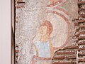
 Early fresco in the northwestern conch depicting Aaron. Discovered when newer layers were removed in recent restoration work.
 -
 Medallion with angel's head, to right of north arch. It is thought 18 similar medallions decorated the eastern arch.


References
- ^ a b c "Red Church". Cultural Corridors of South East Europe. Retrieved 3 February 2010.
- ^ ISBN 954-430-762-1.
- ^ a b "The Red Church". Plovdiv Guide. Archived from the original on 15 July 2011. Retrieved 3 February 2010.
- ^ a b c "Червената църква край Перущица е пред унищожение" (in Bulgarian). Двери БГ. 2009-05-05. Retrieved 3 February 2010.
- ISBN 978-0-7100-6932-0.
- ISBN 978-0-415-23392-7.
- ^ "Паметници: църкви и манастири" (in Bulgarian). Регионална дирекция по горите, Пловдив. Retrieved 3 February 2010. [dead link]
- ^ "Ministry of Culture Republic of Bulgaria". Bulgarian Ministry of Culture. Retrieved 29 August 2013.
- ISBN 978-1-57958-282-1.
- ISBN 978-0-19-504652-6
- ^ Коева, Маргарита (2003). "Ранна християнска архитектура IV-VII в.". Въведение в архитектурната теория и история. Учебник за студенти по изкуствознание (in Bulgarian). LiterNet.
42°4′27″N 24°33′22″E / 42.07417°N 24.55611°E
Capital: Perushtitsa | ||
| Villages |
|  |
| Landmarks | ||
| Culture | ||
| Notable people | ||