
Red Rock Canyon State Park (California)
This article includes a list of general references, but it lacks sufficient corresponding inline citations. (April 2013) |
| Red Rock Canyon State Park | |
|---|---|
California Department of Parks and Recreation |
Red Rock Canyon State Park is a
Each
Location
The park is located on
History
The area was once home to the
The colorful rock formations in the park served as landmarks during the early 1870s for 20-mule team freight wagons that stopped for water. The park protects significant paleontology sites and the remains of 1890s-era mining operations.
1933 and 1999


Between these two photographs, 66 years have elapsed. In the 1933 picture Red Rock Canyon was on
In the 1999 photo, a total of 17 species are now present in the foreground. No Yuccas, Joshua trees or other plants have persisted over the 66 years between the dates of the photographs. In most of the repeat photography, few Yuccas appear to live longer than about 40 years. Many more plants appear in the 1999 view, partially in response to decreased disturbance as well as increased precipitation in the latter part of the 20th century. For example, the road that previously crossed the foreground is difficult to detect. The foreground of this view is geomorphically active, and small rills and gullies cross parts of the foreground. Young geomorphic surfaces, such as that portrayed in this 1999 view, support young plant assemblages that recover relatively quickly following cessation of disturbance.
Filming location
Providing several unique, dramatic areas, and close to
Astronomy
Red Rock Canyon is one of the darkest skies within a two hour driving distance of Los Angeles.[4][5] The dry climate, frequently cloudless skies, and relatively low light pollution enhance nighttime viewing conditions. The park is a Bortle class 2-3 site, ranging from an "average dark sky" in northern regions to a sky typical of a rural area in southern regions.[4] On a clear night with no moon, visitors with good eyesight and dark adapted vision may see both the Andromeda and Triangulum galaxies with the unaided eye, and the central Milky Way shows complex structure from this site.[6] While the southern sky suffers from light pollution from nearby towns, dark sky conditions in the park are nonetheless exceptional relative to nearby urban areas.
Gallery
-
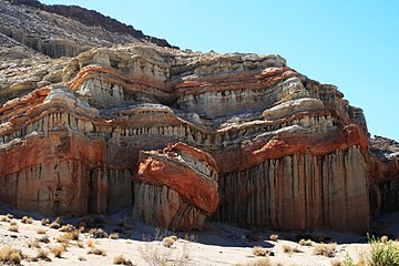 A prominent rock formation near the park entrance.
 -
 Detail of the many hoodoos found along the canyon walls.
 -

-
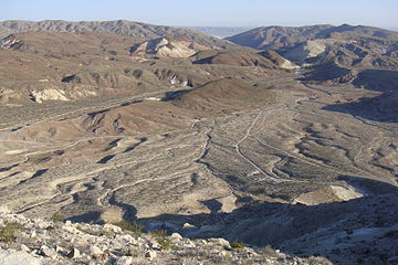 An alluvial plain in the center of the park


.jpg)

See also
Additional sources
- Campbell Grant, James W. Baird and J. Kenneth Pringle. 1968. Rock drawings of the Coso Range, Inyo County, California: an ancient sheep-hunting cult pictured in desert rock carvings, second edition, Maturango Press, 145 pages
- Alan P. Garfinkel. 2004. Dating "Classic" Coso Style Sheep Petroglyphs in the Coso Range and El Paso Mountains: Implications for Regional Prehistory, v.2/15/04
- C. Michael Hogan. 2008. Morro Creek, ed. by A. Burnham [1]
- California Department of Parks & Recreation
- Information from DesertUSA
- USGS Repeat Photography for the Mojave Desert
- Red Rock Canyon State Park (California)
References
- ISBN 0-7894-1451-1.
- ^ Alan P. Garfinkel. 2004
- ^ C.Michael Hogan. 2008
- ^ a b "Light pollution map". www.lightpollutionmap.info. Retrieved July 13, 2018.
- ^ "Los Angeles to Red Rock Canyon State Park". Los Angeles to Red Rock Canyon State Park. Retrieved July 13, 2018.
- ^ "bortle dark sky scale". www.handprint.com. Retrieved July 13, 2018.