
Rongbuk Glacier
| Rongbuk | |
|---|---|
Valley glacier | |
| Location | Tibet |
| Coordinates | 28°6′7″N 86°51′55″E / 28.10194°N 86.86528°E |
 | |
The Rongbuk Glacier (
Discovery
The English climber George Mallory first explored the main Rongbuk Valley and its glacier while searching for possible routes to the summit of Mount Everest, during the first British Everest reconnaissance expedition of 1921.
On the same expedition,
Location(s)

Route to Everest
Climbing expeditions attempting the normal route from Tibet use this glacier to reach the Advanced Base Camp of Mount Everest at the upper end of the East Rongbuk Glacier. From there, climbing expeditions try to summit Everest by the North Col and the northeast ridge.[4]
Environmental
Since 2007, American mountaineer and film-maker David Breashears has been chronicling the rapid disappearance of the Rongbuk glacier due to global climate change. Breashears has retraced the steps of Mallory's 1921 expedition, revealing a significant loss of ice mass across the West, Main and East Rongbuk Glaciers. In partnership with Asia Society and MediaStorm, Breashears' GlacierWorks[5] has made the photos available online. In 80 years, the Rongbuk has shrunk by more than 300 vertical feet across the entire glacier, approximately the height of the Statue of Liberty.
Image gallery
-
 Recent glacial animation, Mount Everest at the top right.
 -
 View of Mount Everest from Rongbuk Valley, near foot/terminus of Rongbuk Glacier.
 -
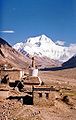 View of Mount Everest and Rongbuk Monastery.


See also
References
- ^ Wade Davis - Into the silence, Vintage Books, London, 2012.
- ^
Eric Simonson, Jochen Hemmleb, and Larry Johnson. "Outside Online Archives". OutsideOnline.com. Archived from the original on 8 January 2009. Retrieved 30 April 2009.
{{cite web}}: CS1 maint: multiple names: authors list (link) - ^ "Expedition to rewrite Everest history". BBC News. 24 March 1999. Retrieved 30 April 2009.
- ^ "NOVA Online – Everest – Climb North – East Rongbuk Glacier". www.pbs.org. Retrieved 30 April 2009.
- ^ "GlacierWorks". www.glacierworks.org. Retrieved 19 April 2018.
External links
- Charles Howard-Bury, George Herbert Leigh-Mallory (1922). Mount Everest: The Reconnaissance, 1921. Retrieved 30 April 2009.
- NOAA.gov: East Rongbuk Glacier, Mount Qomolangma
- Greenpeace.org: "Expedition documents melting Himalayan glaciers"
- Asia Society.org: "On Thinner Ice" Project" — with photos of the Rongbuk Glacier.
