
Rupert River
| Rupert River | |
|---|---|
 | |
 | |
| Native name | Rivière Rupert (French) |
| Location | |
| Country | Canada |
| Province | Quebec |
| Region | Nord-du-Québec |
| Physical characteristics | |
| Source | Lake Mistassini |
| • coordinates | 50°57′0″N 73°42′0″W / 50.95000°N 73.70000°W |
Waskaganish | |
• coordinates | 51°29′0″N 78°46′0″W / 51.48333°N 78.76667°W |
| Length | 763 km (474 mi)[1] |
| Basin size | 43,400 km2 (16,800 sq mi)[2] |
| Discharge | |
| • average | 900 m3/s (32,000 cu ft/s) |
| Discharge | |
| • location | Lake Mistassini outlet |
| • average | 434 m3/s (15,300 cu ft/s) |
| Basin features | |
| Tributaries | |
| • left |
|
| • right |
|
The Rupert River is a river in
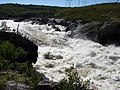
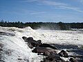
There is some[quantify] extremely large[clarification needed] whitewater on the river, but paddlers[who?] can avoid much of it by portage routes on the side. The most impressive[further explanation needed] falls,[according to whom?] which cannot be avoided except by portaging, are the "Oatmeal Rapids" right at the James Bay Road (a set of cascades dropping 18 m (59 ft)) and "The Fours" near the end of the river (a 24 m (79 ft) drop).[citation needed]
The Rupert has long been an important river for the
Major tributaries of the Rupert are (in downstream order):
- Natastan River (Rivière Natastan)
- Lemare River (Rivière Lemare) - 1,290 km2 (500 sq mi) subbasin
- Marten River (Rivière à la Marte) - 4,505 km2 (1,739 sq mi) subbasin
- Nemiscau River (Rivière Nemiscau) - 3,015 km2 (1,164 sq mi) subbasin
History
In 1668, an expedition led by
While having lost its importance as a trade route, the Rupert River has long been a popular destination for recreational canoe camping and whitewater canoeing.
Hydroelectric development

The Rupert, together with the
rivers, and the NBR Project was shelved.The plan to divert the Rupert's headwaters into the
After completion of the joint environmental assessments by the Cree, Quebec and Canadian authorities, the governments of Quebec and Canada authorized the diversion and construction of hydroelectric installations on the Rupert River in late 2006. The diversion of water from the river began in November, 2009. 29,600 square kilometres (11,400 sq mi) or 68% of its basin will be diverted through a 2.9 kilometres (1.8 mi) long transfer tunnel from the Rupert Forebay to the Rupert Tailbay in the Nemiscau basin and then onward to the Eastmain 1 Reservoir. The remaining work was complete in 2012.[4]
Image gallery
-
 Rupert River at the Route du Nord
 -
 The Rupert River lookout
 -
 The Rupert River at the James Bay Road.
 -
 Close-up of the Oatmeal Rapids


,_Oatmeal_Rapids.jpg)
See also
References
- ^ Measured to the head of Rivière Témiscamie; source: Natural Resources Canada, Atlas of Canada - Rivers
- ^ Original watershed; source: Natural Resources Canada, Atlas of Canada - Rivers
- ^ "Rivers of the World: the Rupert in Canada", Radio Netherlands Archives, January 31, 2003
- ^ Hydro-Quebec
External links
- The Rupert River website
- The James Bay Road website - the James Bay region of Quebec
- Save the Rupert
- Rupert Reverence
- The Rupert Hydroelectric Diversion (Hydro-Québec)
- Environmental assessment process and documents (Ministry of the Environment of Québec) (fr)
- Environmental assessment process and documents (Canadian Environmental Assessment Agency)
- "Hydro-Electric Project to Reshape Wilderness" July 14, 2008 NPR radio report
- Rezmutt's Flickr.com Rupert River Archive
- The Rupert River (YouTube Video)