
Sürmene
Sürmene | |
|---|---|
District and municipality | |
 Memiş Ağa Mansion in Sürmene | |
 Map showing Sürmene District in Trabzon Province | |
 Sürmene Location in Turkey | |
| Coordinates: 40°54′51″N 40°06′45″E / 40.91417°N 40.11250°E | |
| Country | Turkey |
| Province | Trabzon |
| Government | |
| • Mayor | Rahmi Üstün (AKP) |
| Area | 166 km2 (64 sq mi) |
| Elevation | 20 m (70 ft) |
| Population (2022)[1] | 25,950 |
| • Density | 160/km2 (400/sq mi) |
| Time zone | UTC+3 (TRT) |
| Postal code | 61600 |
| Area code | 0462 |
| Climate | Cfa |
| Website | www |
Sürmene (Turkish: ).
Sürmene (Humurgan)
Economy
Historically, Sürmene produced small amounts of manganese. The area also had mineral springs, and shipped bottled water to Istanbul.[6]
Composition
There are 37
- Aksu
- Armutlu
- Aşağıovalı
- Balıklı
- Birlik
- Çamburnu
- Çamlıca
- Çarşı
- Çavuşlu
- Çiftesu
- Çimenli
- Dirlik
- Fındıcak
- Gültepe
- Güneyköy
- Kahraman
- Karacakaya
- Konak
- Koyuncular
- Küçükdere
- Muratlı
- Ormanseven
- Ortaköy
- Ortamahalle
- Oylum
- Petekli
- Soğuksu
- Üstündal
- Üzümlü
- Yazıoba
- Yemişli
- Yeniay
- Yeşilköy
- Yokuşbaşı
- Yukarıçavuşlu
- Yukarıovalı
- Zeytinli
Flora and fauna
According to WWF the largest amount of endemic flora is to be found in the Ağaçbaşı yayla (summer upland pasture) in Sürmene.[8]
- Zehirli biberiye (Andromeda polifolia),
- Böcek yiyen bitkilerden Drosera,
- Pamukotu (Eriophorum angustifolium ve E. latifolium),
- Kurtayağı (Lycopodiella inundata),
- Kara ot (Rhynchospora alba)
Gallery
-
 The Sürmeme Chamber of Commerce was the first chamber of commerce in Turkey
 -
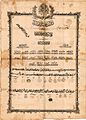 SürmeneAgha Shahadetnamesi (Diploma)
 -
 [9] Çavuşzade Muhammed Ağa's gravestone
 -
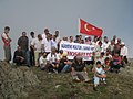 Sürmene Festival on the top of Madur mountain.
 -
 Fatih Akın Turkish film director from Çamburnu, a village of Sürmene
 -
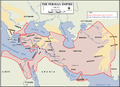 The route that brought Xenophon'sTen Thousandto Sürmene


See also
- Memiş Aga Mansion
- Memiş Agha
- Madur
- Anabasis (Xenophon)
- Ten Thousand
- Sürmene knife
References
- ^ TÜİK. Retrieved 19 September 2023.
- ^ Büyükşehir İlçe Belediyesi, Turkey Civil Administration Departments Inventory. Retrieved 19 September 2023.
- ^ "İl ve İlçe Yüz ölçümleri". General Directorate of Mapping. Retrieved 19 September 2023.
- ^ "An Overview of Rize's History". Republic of Turkey Ministry of Culture and Tourism. Archived from the original on September 29, 2007. Retrieved 2008-04-11.
- ^ "Humurgan". T.C. Kültür ve Turizm Bakanlığı. Retrieved 8 March 2023.
- ^ Prothero, W. G. (1920). Armenia and Kurdistan. London: H.M. Stationery Office. p. 73.
- ^ Mahalle, Turkey Civil Administration Departments Inventory. Retrieved 19 September 2023.
- ^ [1][permanent dead link]
- ^ "Çavuşpaşa.ni̇noğlu. Muhammetağa. Bölük.no.13.Öl. 1718".