Saky Raion
Saky Raion
Сакський район | ||
|---|---|---|
 Airbase at Novofedorivka, Saky District | ||
|
Country | ||
Capital | Saky | |
| Subdivisions | List
| |
| Area | ||
| • Total | 2,257 km2 (871 sq mi) | |
| Population (2014) | ||
| • Total | 76,489 | |
| • Density | 34/km2 (88/sq mi) | |
UTC+3 (MSK) | ||
| Dialing code | +380-6563 | |
| Website | sakirs.ru | |
Saky Raion (
2014 Census).[1]
The district includes the urban-type settlement of Novofedorivka.

2020 Ukrainian Administrative Reform
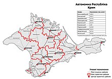
In July 2020, Ukraine conducted an administrative reform throughout its de jure territory. This included Crimea, which was at the time occupied by Russia, and is still ongoing as of October 2023. Crimea was reorganized from 14 raions and 11 municipalities into 10 raions, with municipalities abolished altogether.
Saky Raion was abolished, and its territories to become a part of Yevpatoria Raion, but this has not yet been implemented due to the ongoing Russian occupation.[2]
Demographics
As of the
Belarusians.[3]
References
- Federal State Statistics Service. Retrieved January 4, 2016.
- ^ "Про утворення та ліквідацію районів". Офіційний вебпортал парламенту України (in Ukrainian). Retrieved 2023-10-16.
- ^ https://web.archive.org/web/20120828162929/http://sf.ukrstat.gov.ua/perepis1.htm#_jaz
External links
 Media related to Category:Saky at Wikimedia Commons
