Saltfleetby
This article needs additional citations for verification. (November 2018) |
Shire county | ||
| Region | ||
|---|---|---|
| Country | England | |
| Sovereign state | United Kingdom | |
| Post town | LOUTH | |
| Postcode district | LN11 | |
| Police | Lincolnshire | |
| Fire | Lincolnshire | |
| Ambulance | East Midlands | |
| UK Parliament | ||
Saltfleetby is a village and
2001 Census, decreasing to 568 at the 2011 Census.[1]
A local name for the village is Soloby.[2]
Until 1999 Saltfleetby comprised three parishes: Saltfleetby St Peter, Saltfleetby All Saints and Saltfleetby St Clement, each one centred on the church that gave it its name.[3]
The hamlet of Three Bridges is south of Saltfleetby St Peter.
Saltfleetby contains a wooden village hall,public house.
Saltfleetby Gas Field, north of North End Lane, is part of the neighbouring village of South Cockerington
.
Second World War

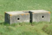
The
Home Guard
shelter in the field adjacent to The Prussian Queen.
Geography and ecology
A section of the parish seashore is salt marsh between Saltfleetby and the
Grey seals breed farther north in Donna Nook nature reserve within the Saltfleet and North Somercotes
parishes.
See also
References
- ^ "Parish population 2011". Retrieved 22 August 2015.
- ^ Saltfleetby Group Parish Council, Lincolnshire County Council Retrieved 11 October 2016
- ^ "East Lindsey (Parishes) Order 1999" (PDF). HMSO. Retrieved 14 February 2023.
- ^ "Saltfleetby Village hall", Lincolnshire County Council. Retrieved 24 November 2018
- ISBN 1-902771-53-2.
- ^ "Natterjack toad guide: how to identify, where they're found, and why they're rare in the UK". Discover Wildlife. Our Media Ltd. Retrieved 29 April 2022.
External links
 Media related to Saltfleetby at Wikimedia Commons
 Saltfleetby travel guide from Wikivoyage
- Saltfleetby-Theddlethorpe Dunes National Nature Reserve; Natural England. Retrieved 18 May 2012
- Saltfleetby C of E Primary School
