
San Pedro River (Arizona)
| San Pedro River Rio San Pedro, Cananea, Mexico, Mexico | |
|---|---|
| • coordinates | 31°12′04″N 110°12′28″W / 31.20111°N 110.20778°W[1] |
| • elevation | 4,460 ft (1,360 m) |
Pinal County, United States | |
• coordinates | 32°59′04″N 110°47′01″W / 32.98444°N 110.78361°W[1] |
• elevation | 1,919 ft (585 m) |
| Basin features | |
| Tributaries | |
| • left | Babocomari River |
| • right | Aravaipa Creek |
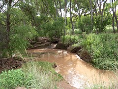
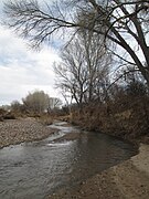
The San Pedro River is a northward-flowing stream originating about 10 miles (16 km) south of the international border south of Sierra Vista, Arizona, in Cananea Municipality, Sonora, Mexico. The river starts at the confluence of other streams (Las Nutrias and El Sauz) just east of Sauceda, Cananea.[3] Within Arizona, the river flows 140 miles (230 km) north through Cochise County, Pima County, Graham County, and Pinal County to its confluence with the Gila River, at Winkelman, Arizona. It is the last major, undammed desert river in the American Southwest,[4] and it is of major ecological importance as it hosts two-thirds of the avian diversity in the United States, including 100 species of breeding birds and almost 300 species of migrating birds.[5]
History


The first people to enter the San Pedro Valley were the Clovis people who hunted mammoth here from 10,000 years ago. The San Pedro Valley has the highest concentration of Clovis sites in North America.
The hunter-gatherer,
The first Europeans to visit the San Pedro River may have been the parties of
It is widely believed that by 1762 Apache depredation drove the Sobaipuri and Spanish out of the San Pedro Valley which then remained largely uninhabited until the early 1800s.[9] This, however, is not true as a recent study has shown.[10] Documents state that not all the Sobaipuri left and in the 1780s Sobaipuri were noted still living along the river. Archaeology has confirmed additional Sobaipuri settlements along the middle San Pedro not mentioned in the documentary record throughout the 1800s.
Early American exploration of the San Pedro River, like most rivers in western North America, was driven by the pursuit of beaver pelts. James Ohio Pattie and his father led a party of fur trappers down the Gila River and then down the San Pedro River in 1826 which was so successful that he called the San Pedro the Beaver River.[2] The party was attacked by Apache Indians (probably the Aravaipa Band) at "Battle Hill" (probably Modern-day Malpais Hill) where they subsequently stashed and lost over 200 beaver pelts.[11]
The
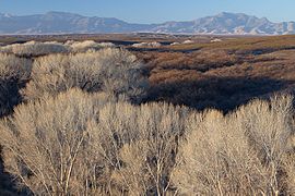
In the 19th century the river was a meandering stream with fluvial marshlands, riparian forest, Sporobolus grasslands and extensive beaver ponds. As the region experienced a rapid climate warming and drying,[14] (coincident with beaver removal and large-scale cattle introduction; correlation not directly established) the river down-cut and then widened in a process of arroyo formation observed on many rivers in the Southwest.[15] In 1895, J. A. Allen described a mammal collection from southeastern Arizona, "On the headwaters of the San Pedro, in Sonora, a colony of a dozen or more had their lodges up to 1893, when a trapper nearly exterminated them. All the streams in the White Mountains have beaver dams in them, although most of the animals have been trapped."[16] The beaver were finally extirpated by 1920s dynamiting of the beaver dams from soldiers from Fort Huachuca to prevent malaria.[citation needed] By the mid-20th century the once perennial river only flowed during the rainy season and beaver, fluvial marshlands and Sporobolus grasslands were uncommon.[15][17] Physician naturalist Edgar Alexander Mearns' 1907 Mammals of the Mexican boundary of the United States reported beaver (Castor canadensis) on the San Pedro River and the Babocomari River.[18] Mearns claimed that the San Pedro River beaver represented a new subspecies Castor canadensis frondator or "Sonora beaver" that ranged from Mexico up to Wyoming and Montana.[19]
Ecology
.jpg)
(Melanoplus aridus)
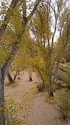
The San Pedro River is the central corridor of the Madrean Archipelago of "Sky Islands", high mountains with unique ecosystems different from the ecology of the Sonoran desert "seas" that surround it.[20]
More than 300 species of
In recent decades, rapid growth and population increases in southern Arizona has caused concern with this river. Several non-profit organizations have risen in recent years to raise awareness of this problem. The
.jpg)
With large portions of the river dry much of the year,
Watershed


The San Pedro drains an area of approximately 4,720 square miles (12,200 km2) in Cochise, Graham, Pima, and Pinal Counties. Its course traverses deep sedimentary basins flanked by the Huachuca, Mule, Whetstone, Dragoon, Rincon, Little Rincon, Winchester, Galiuro, Tortilla, and Santa Catalina Mountains. The San Pedro is fed by numerous tributaries, which in general, drain relatively short and steep catchments oriented more or less perpendicular to the mainstem.[27] For most of its length the San Pedro flows over sedimentary basin fill deposits, although it is bound by bedrock at the Tombstone Hills at Charleston and near Fairbank, “the Narrows” south of Cascabel, near Redington, and again at Dudleyville (Heindl, 1952). Two major tributaries, Babocomari River and Aravaipa Creek, each have extensive bedrock-lined stretches. Historically the San Pedro has been divided into upper and lower reaches at the Narrows.[28]
On May 27, 2011, a U.S. District judge ruled that Fort Huachaca's plan to pump 6,100 acre-feet (7,500,000 m3) of groundwater without mitigation plans to replenish the San Pedro River flows failed to protect the endangered
The river's watershed is threatened by the Mexico–United States border wall, as Secretary of Homeland Security Michael Chertoff waived the Endangered Species Act of 1973, Clean Water Act, and National Environmental Policy Act, in order to build a wall.[30]
Geology, paleontology
The
In recent decades, the Arizona Geological Society has focused on the region, as well as researchers. Development pressures, recreation, and groundwater harvesting have led to recent concerns of protecting the region. A recent floodplain study focused on the Holocene floodplain alluvium and its history, over a 125-mile (201 km) stretch of the river to understand subground waterflow resources.[28]

Picture gallery
-
 Pipevine Swallowtail Butterfly
 -
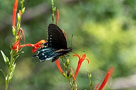 Pipevine Swallowtail Butterfly
 -

-

-

-

-
-

-
-
-

-
-

-

.jpg)
.jpg)


.jpg)
.jpg)

.jpg)


.jpg)
.jpg)
See also
- San Pedro Riparian National Conservation Area
- List of Arizona rivers
- List of tributaries of the Colorado River
- From Desert to Sky Islands
References
- ^ a b c U.S. Geological Survey Geographic Names Information System: San Pedro River
- ^ ISBN 978-0-8061-1702-7. Retrieved May 31, 2010.
- ^ Nogales, Arizona, 30x60 Topographic Quadrangle, USGS, 994
- ^ a b Tony Davis (2011-06-01). "Ruling faults analysis of pumping, San Pedro". Arizona Star. Archived from the original on 2018-07-13. Retrieved 2011-06-02.
- ^ a b "San Pedro River, Arizona". The Nature Conservancy. Archived from the original on 2010-05-01. Retrieved May 31, 2010.
- ^ "SURVEY OF THE UPPER SAN PEDRO VALLEY ARIZONA AND SONORA, MEXICO". Department of Anthropology, University of Arizona. Retrieved October 29, 2010.
- ^ Flint, Richard and Shirley. The Latest Word from 1540.
- ^ "Huachuca Illustrated, A Magazine of the Fort Huachuca Museum, Vol. 4 1999" (PDF). U.S. ARMY, FORT HUACHUCA. Retrieved October 29, 2010.
- ^ "Aravaipa Canyon Wilderness Prehistory and History". U.S. DEPARTMENT OF THE INTERIOR, BUREAU OF LAND MANAGEMENT. Archived from the original on July 26, 2010. Retrieved October 29, 2010.
- ^ Seymour, Deni (Summer 2011). "1762 On the San Pedro: Reevaluating Sobaípuri-O'odham Abandonment and New Apache Raiding Corridors". The Journal of Arizona History. 52 (2): 169–188.
- ^ Batman, Richard (1984). American Ecclesiastes. Harcourt Brace Jovanovich.
- Roberts, B.H. (1919). The Mormon Battalion: Its History and Achievements. Salt Lake City: Deseret News.
- ^ Sue Kartchner (Feb 24, 2009). "Popular costume ball set Saturday". San Pedro Valley News Sun. Retrieved May 31, 2010.
- ^ Turner, Webb. The Changing Mile. University of Arizona Press.
- ^ doi:10.1002/eco.62.
- ^ J. A. Allen (1895). "On a Collection of Mammals from Arizona and Mexico, Made by Mr. W. W. Price" (PDF). Bulletin of the American Museum of Natural History. Retrieved 2012-05-22.
- ^ a b c Paul Young (May 27, 2010). "Environmental Engineers: Beaver on the San Pedro River". Desert Leaf. Archived from the original on January 30, 2013. Retrieved May 31, 2010.
- ^ Edgar Alexander Mearns (1907). Mammals of the Mexican boundary of the United States: A descriptive catalogue of the species of mammals occurring in that region; with a general summary of the natural history, and a list of trees. Government Printing Office. p. 359. Retrieved 2011-11-24.
beaver sonora.
- ^ Edgar A. Mearns (1897). "Preliminary Diagnosis of the New Mammals of the Genera Sciurus, Castor, Neotoma, and Sigmodon, from the Mexican Border of the United States" (PDF). Proceedings of the U.S. National Museum. Retrieved 2011-11-25.
- ^ "San Pedro River Ecology". San Pedro River Valley Organization. Archived from the original on December 17, 2010. Retrieved May 31, 2010.
- ^ "The San Pedro Riparian National Conservation Area". US Dept. of the Interior. Archived from the original on January 19, 2015. Retrieved May 31, 2010.
- ^ "Rancho Los Fresnos and the San Pedro River". The Nature Conservancy. 2009. Retrieved May 31, 2010.
- ^ Susan K. Skagen; Rob Hazlewood; Michael L. Scott (2005). The Importance and Future Condition of Western Riparian Ecosystems as Migratory Bird Habitat (PDF). USDA Forest Service Gen. Tech. Rep. PSW-GTR-191 (Report). pp. 525–527. Retrieved May 31, 2010.
- ^ Glenn Johnson; Charles van Riper III (2007). Influence of Beaver Activity, Vegetation Structure, and Surface Water on Riparian Bird Communities along the Upper San Pedro River, Arizona (PDF) (Report). School of Natural Resources, University of Arizona, USGS Sonoran Desert Research Station. Retrieved May 31, 2010.
- ^ Mike Foster (August 2011). "Reintroduction of the Beaver to the San Pedro River of Southeastern Arizona". Retrieved 2011-09-11.
- ^ Glenn E. Johnson; Charles van Riper III (2014). Effects of reintroduced beaver (Castor canadensis) on riparian bird community structure along the upper San Pedro River, southeastern Arizona and northern Sonora, Mexico (PDF) (Report). U.S. Geological Survey. Open-File Report 2014-1121. Retrieved 2015-01-23.
- ^ Huckleberry G, Lite SJ, Katz GL, Pearthree P (2009). Stromberg JS, Tellman B (eds.). Fluvial Geomorphology in Ecology and Conservation of the San Pedro River. Tucson,Arizona: University of Arizona Press.
- ^ a b Joseph P. Cook; et al. (2009). Mapping of Holocene River Alluvium along the San Pedro River, Aravaipa Creek, and Babocomari River, Southeastern Arizona (PDF) (Report). Arizona Geological Society. Retrieved 2015-01-01. Document repository for report map files
- ^ "Court Rejects Fort Huachuca's Groundwater Pumping Plan". Center for Biological Diversity. Retrieved September 3, 2017.
- ^ "What a Border Wall Could Mean for Wildlife | Audubon". www.audubon.org. Retrieved 2023-12-03.
External links
- Nature Conservancy Webpage
- Mountain Visions website writeup
- This page explores many features of the valley
- Aviatlas: Birding along San Pedro
- Center for Biological Diversity San Pedro River page
- Huachaca water umbel at Pima County website
Geology, groundwater, paleontology
- "Geology of the San Pedro River, Aravaipa Creek, and Babocomari River"
- Anti-development, (Bypass-route)
| Authority control databases: National |
|---|