Sasanoa River
Appearance
Source: Wikipedia, the free encyclopedia.
River in the United States
| Sasanoa River | |
|---|---|
| Location | |
| Country | United States |
| Physical characteristics | |
| Source | |
| • location | Maine |

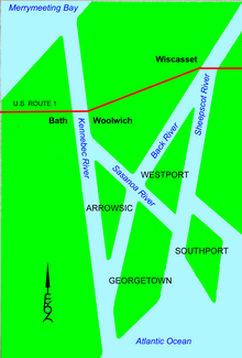
The Sasanoa River is an 8.6-mile-long (13.8 km)[1] tidal channel in the Midcoast region of Maine, connecting the Kennebec River with the Sheepscot River.
The Sasanoa River has two distinct sections. The western section begins at the Kennebec River opposite the city of
Westport and Georgetown
.
See also
References
- ^ U.S. Geological Survey. National Hydrography Dataset high-resolution flowline data. The National Map, accessed June 22, 2011
- U.S. Geological Survey Geographic Names Information System: Sasanoa River
- Maine Streamflow Data from the USGS
- Maine Watershed Data From Environmental Protection Agency
43°51′41″N 69°43′34″W / 43.86147°N 69.72616°W / 43.86147; -69.72616
This article related to a river in Maine is a stub. You can help Wikipedia by expanding it. |
