
Saxon Switzerland
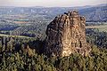
 View of the Lilienstein in Saxon Switzerland | |
| Native name | Sächsische Schweiz |
|---|---|
| Natural region | Elbe Sandstone Mountains |
| Natural region characteristics | |
| Landscape type | Landscape |
| Highest point | Großer Zschirnstein (562 m) |
| Settlements | Pirna, Bad Schandau, Sebnitz, Rathen |
| County/District | Sächsische Schweiz-Osterzgebirge |
| State(s) | Saxony |
| Country | Germany |
.jpg)


Saxon Switzerland (
The administrative district for the area is
Etymology
The German name for Saxon Switzerland, Sächsische Schweiz, appeared in the 18th century. Two Swiss artists, Adrian Zingg and Anton Graff, were appointed in 1766 to the Dresden Academy of Art.
From their new, adopted home they look eastwards and saw, about a day's walk away, a hill range. It had a strange, flattish profile, without any actual summits […]
— according to Lothar Kempe[1]
They felt the landscape was reminiscent of their homeland, the
The description became popular through the publication of the name by Wilhelm Lebrecht Götzinger. In his books he described the area as Saxon Switzerland and made the term known to a wide audience.
In English the usual translation is "Saxon Switzerland".[2][3][4][5] However other sources call it "Saxony Switzerland"[6] or even "Swiss Saxony".[7]
Geography

Saxon Switzerland forms the northern part of the Elbe Sandstone Mountains range, located on the German-Czech border. To the east, it transitions into the Lusatian Highlands and, to the west, into the Ore Mountains. The Czech part of the Elbe Sandstone Mountains is partly formed by the Bohemian Switzerland national park. The highest elevation in Saxon Switzerland is the Großer Zschirnstein at 562 m above sea level.
Natural region classification
In the classification of natural regions by Emil Meynen, Saxon Switzerland was a major unit (430) within the Saxon-Bohemian Chalk Sandstone Region (main unit group 43), whose only other major unit on German soil was the Zittau Mountains. The boundary between the two mountain ranges, the Elbe Sandstone Mountains and the Lusatian Mountains, is located on Czech territory, which is why these natural regions are geographically separated from one another.
The Ecosystem and Regional Character working group of the
Geological formation
See Elbe Sandstone Mountains (Geology section)
Hills
As a rule, two types of hill may be distinguished.
Numerous rock formations in the
The
History

During the Dark Ages, the region was settled by Slavs and was part of the Kingdom of Bohemia during the Middle Ages. About 1000 years ago Bohemian-Saxon Switzerland was the borderland of three Slavic tribes. The Nisane tribe (east of the Elbe from Dresden to Pirna), the Milzane tribe (from today's Upper Lusatia) and in the south the Dacine tribe shaped the political and economic landscape at that time.
It was not until the 15th century that the area now called Saxon Switzerland came under
The development of the area for tourism began in earnest in the 19th century. This was greatly helped by the building of one of the first trolleybus lines in the world: the Biela Valley Trolleybus, which was in operation from 1901 to 1904 and was operated from Königstein.
Romantic artists were inspired by the beauty of wilderness, like the painter Ludwig Richter or the composer Carl Maria von Weber, who set his famous opera Der Freischütz with its Wolfsschlucht ("Wolf's Gorge") scene set near the town of Rathen.
In the
Medieval castles
When Germans began to settle in the 13th century, there was a systematic banishment of Bohemian influence and numerous local military conflicts erupted around strategically important fortifications. These fortifications primarily serve to protect the border and trading routes. Due to a lack of central power this protective function was left to local knights. The progressive division of the area due to the hereditary distribution of estates upset the economic balance of the region and many castles degenerated into bases for robber barons.
Not until the middle of the 16th century, when the Wettins captured many of the castles did the situation stabilise. Today, these castles and ruins, some of which are well preserved, are popular with tourists, who make their way to these sites up steep climbing paths.
These castles include:
.National park

In September 1990, even before the
Rock climbing
Saxon Switzerland is characterized by its
A Saxon oddity is the concept of a Baustelle (literally "building site") where climbers scale a difficult section by climbing on top of the shoulders of other climbers (sometimes several people on top of each other) with everybody involved only holding himself by holds the rock provides. Though this would normally be considered a form of aid climbing, it is here accepted as a form of free climbing. As the pinnacles are often very close to one other, jumping from one rock to another is also rather popular and this technique even has its own grades of difficulty.
In addition to the climbing summits there are also various steep paths, on which hikers with
Boofen
A Boofe (plural: Boofen) is local slang for sleeping out overnight in the open under a rock overhang and has a long tradition in Saxon Switzerland. Many young people travel to Saxon Switzerland at weekends in order to boofen. Today it is only permitted by the National Park Authority at designated sites. However the growing number of Boofers and the bad conduct of individuals (e.g. who light illegal campfires, tear up saplings or cause soil erosion) has led to repeated altercations.
Points of interest
_2006-03-25.jpg)

- Bastei and Neurathen Castle
- Bärensteine and Rauenstein near Weißig
- Biela Valley
- Stolpen Castle
- Ruins of Wehlen Castle
- Rock arch near Wehlen
- Frienstein and the Ida Grotto
- Mount Gohrisch with its refuge hut
- Kaiserkrone and Zirkelstein
- Kirnitzschtal Tramway, an historic interurbanin the Kirnitzsch valley
- Little Saxon Switzerland, a miniature park layout in the village of Wehlen
- Königstein Fortress, the largest hill fortress in Europe
- Kuhstall on the New Wildenstein
- Lilienstein, Schrammsteine
- Hinterhermsdorf
- Rathen Open-Air Stage, an open-air theatre
- Papststein with observation tower and restaurant
- Pfaffenstein and the Barbarine
- Wolfsberg
- Bad Schandau Botanical Gardens, a regional botanical garden
Panorama

See also
Gallery
-
 View from the Bastei
 -
 View of the Elbe River from Bastei
 -
 View from Königstein fortress to Lilienstein and Elbe
 -
-
 Climbing in the Biela valley
 -
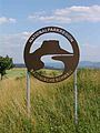 National Park sign


References
- ^ a b Sieghard Liebe, Lothar Kempe: Sächsische Schweiz und Ausflüge in die Böhmische Schweiz. Brockhaus, Leipzig 1974, (in German). p. 5
- ISBN 978-3-7301-0522-1.
- ISBN 978-3-8297-6611-1.
- ^ Saxon Switzerland at www.saechsische-schweiz.de. Accessed on 9 September 2011.
- ^ Saxon Switzerland at www.ceskosaske-svycarsko.cz. Accessed on 9 September 2011.
- ^ Saxony Switzerland at www.saxony-switzerland.de/ Accessed on 9 September 2011.
- ISBN 9781906261382.
- ^ Map of natural regions in Saxony Archived 19 July 2011 at the Wayback Machine at www.umwelt.sachsen.de (pdf, 859 kB)
- ^ Statistik des Deutschen Reichs, Band 450: Amtliches Gemeindeverzeichnis für das Deutsche Reich, Teil I, Berlin 1939; page 272
- ISBN 978-3-7562-9194-6.
Sources
- Autorenkollektiv: Brockhaus Reisehandbuch Sächsische Schweiz – Osterzgebirge. Leipzig 1970.
- Wilhelm Lebrecht Götzinger: Schandau und seine Umgebungen, oder Beschreibung der Sächsischen Schweiz. Begersche Buch- und Kunsthandlung, Dresden 1812.
- Heinz Klemm: Die Entdeckung der Sächsischen Schweiz. Sachsenverlag, Dresden 1953.
- Alfred Meiche: Die Burgen und vorgeschichtlichen Wohnstätten der Sächsischen Schweiz. Wilhelm Baensch Verlagsbuchhandlung, Dresden 1907. (Reprint Leipzig 1979)
- Alfred Meiche: Historisch-topographische Beschreibung der Amtshauptmannschaft Pirna. Dresden 1927.
- Michael Bellmann: Der Klettersteigführer: Klettersteige und Stiegen in der Sächsischen Schweiz. Dresden 2019.
External links
- Official portal of the destination Saxon Switzerland (in English)
- Tourism Portal Saxon Switzerland
- Info-Portal Saxon Switzerland (en)
50°56′N 14°12′E / 50.933°N 14.200°E
| International | |
|---|---|
| National | |