
Selhurst
| Selhurst | |
|---|---|
.jpg) The Two Brewers pub, Selhurst | |
 Selhurst Location within Greater London | |
| Population | 18,087 (2011 Census. Ward)[1] |
| OS grid reference | TQ340684 |
| London borough | |
| Ceremonial county | Greater London |
| Region | |
| Country | England |
| Sovereign state | United Kingdom |
| Post town | LONDON |
| Postcode district | SE25 |
| Post town | CROYDON |
| Postcode district | CR0 |
| Dialling code | 020 |
| Police | Metropolitan |
| Fire | London |
| Ambulance | London |
| UK Parliament | |
| London Assembly | |
Selhurst is an area in the London Borough of Croydon, England, 7.8 miles (12.6 km) south-south-east of Charing Cross. Historically it lays in Surrey. The area is bounded to the west and south by Thornton Heath and Croydon and to the east and south by South Norwood and Woodside. Selhurst Park, the home stadium of Crystal Palace Football Club, is sited at the northern end of the neighbourhood.
History
Selhurst is named after the Old English for "dwelling in a wood", or possibly 'dwelling where willows grow'; the name is first recorded in 1225.[2] Saxon coins were found here when the railway station was built.[2] Housing began to be built in the area following the opening of the Croydon Canal in 1809, however the canal proved to be a failure and it closed in 1836.[2] Races were held at Heaver's Farm in the 1850s-60s.[2] Further housing development occurred following the opening of Selhurst train station in 1865.[2]
Demography
White British is the largest ethnic group as of the 2011 census, forming 26% of the population. The second and third largest were Black Caribbean and Black African, both 14% each.
The median house price in Selhurst ward in 2014 was £212,998, which is the 17th lowest out of the 628 wards of Greater London.[4]
Education
The
Transport
London Bus Route 75 and London Bus Route 157 both run the length of Selhurst Road, terminating at Croydon and Lewisham (75) and Morden and Crystal Palace (157).
Notable residents
- Samuel Coleridge-Taylor (1875–1912), composer, lived at 30 Dagnall Park.[7]
Gallery
-
 Samuel Coleridge-Taylor's House, Dagnall Park
 -
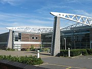 The BRIT School
 -
 Selhurst Park, home of Crystal Palace F.C.
 -
![Selhurst War Memorial, a grade II listed structure[8]](//upload.wikimedia.org/wikipedia/commons/thumb/1/15/Selhurst_War_Memorial_Grade_II_listed.jpg/180px-Selhurst_War_Memorial_Grade_II_listed.jpg) Selhurst War Memorial, a grade II listed structure[8]
Selhurst War Memorial, a grade II listed structure[8] -
![Seventh Day Adventist Church, Selhurst, originally built as a Congregationalist church in 1865[9]](//upload.wikimedia.org/wikipedia/commons/thumb/e/ea/Seventh-day_Adventist_Church%2C_Selhurst.jpg/112px-Seventh-day_Adventist_Church%2C_Selhurst.jpg) Seventh Day Adventist Church, Selhurst, originally built as aCongregationalist church in 1865[9]
Seventh Day Adventist Church, Selhurst, originally built as aCongregationalist church in 1865[9] -
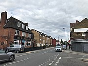 Shops along Northcote Road/Selhurst Road
 -
 King George's Field


![Selhurst War Memorial, a grade II listed structure[8]](/File:Selhurst_War_Memorial_Grade_II_listed.jpg)
![Seventh Day Adventist Church, Selhurst, originally built as a Congregationalist church in 1865[9]](/File:Seventh-day_Adventist_Church,_Selhurst.jpg)


References
- ^ "Croydon Ward population 2011". Neighbourhood Statistics. Office for National Statistics. Retrieved 10 October 2016.
- ^ a b c d e f g Willey, Russ (2006). The London Gazzetteer. Chambers Harrap Publishers Ltd. pp. 433–4.
- ^ "Selhurst". UK Census Data. 2011. Retrieved 25 September 2019.
- ^ "Ward Profiles and Atlas – London Datastore". Retrieved 4 February 2021.
- ISBN 1-85260-297-X.
- ISBN 978-0-9549866-4-3.
- ^ "COLERIDGE-TAYLOR, SAMUEL (1875-1912)". English Heritage. Retrieved 31 August 2020.
- ^ "Selhurst War Memorial". British Listed Buildings. Retrieved 26 September 2019.
- ^ Cleal, Edward E (1908). The Story of Congregationalism in Surrey.