
Shibata, Niigata
Shibata
新発田市 | |
|---|---|
 Clockwise from top: Shibata Castle, Shimizuen garden, Zoni, Tsukiokaonsen, JGSDF Camp Shibata, Kingyo Daiwa | |
|
Sakura | |
| • Flower | Iris |
| Phone number | 0254-22-3030 |
| Address | 3-3-3 Chūōchō, Shibata-shi, Niigata-ken 957-8686 |
| Website | Official website |
.jpg)
Shibata (新発田市, Shibata-shi) is a city in Niigata Prefecture, Japan. As of 31 December 2020[update], the city had an estimated population of 96,236 in 37,017 households,[1] and a population density of 179 persons per km². The total area of the city was 533.10 square kilometres (205.83 sq mi).[2]
Geography
Shibata is located in a mostly inland region of north-central Niigata Prefecture on the northern end of the Echigo Plain, with a small shoreline of the Sea of Japan.
Surrounding municipalities
Climate
Shibata has a Humid climate (Köppen Cfa) characterized by warm, wet summers and cold winters with heavy snowfall. The average annual temperature in Shibata is 13.0 °C. The average annual rainfall is 1920 mm with September as the wettest month. The temperatures are highest on average in August, at around 26.2 °C, and lowest in January, at around 1.2 °C.[3]
Demographics
Per Japanese census data,[4] the population of Shibata peaked around the year 2000 and has been in decline since then.
| Year | Pop. | ±% |
|---|---|---|
| 1960 | 103,738 | — |
| 1970 | 101,245 | −2.4% |
| 1980 | 102,134 | +0.9% |
| 1990 | 104,499 | +2.3% |
| 2000 | 106,016 | +1.5% |
| 2010 | 101,202 | −4.5% |
| 2020 | 94,927 | −6.2% |
History
The area of present-day Shibata was part of ancient
Government
Shibata has a
Economy
The economy of Shibata is dominated by the agricultural sector, with rice as the primary crop. Industries include sake brewing and plastics components production.
Education
Shibata has 19 public elementary schools and 10 public junior high schools operated by the city government. The city has seven public high schools operated by the Niigata Prefectural Board of Education, and the prefecture also operates one special education school for the handicapped. Keiwa College is also located in Shibata.
Transportation
Railway
Highway
 Nihonkai-Tōhoku Expressway
 National Route 7
 National Route 113
 National Route 290
 National Route 460
Sister city relations
 - Uijeongbu, Gyeonggi Province, South Korea[5] (friendship city)
 - St. James, Missouri, US[5]
- - Orange City, Iowa, US[5]
Local attractions
- Shibata Castle (新発田城, Shibata-jō) is the main visitor attraction and provide the backdrop to the spring cherry blossom viewing parties.
- Shimizuen (清水園) Garden
- Ijimino Park (五十公野公園, Ijimino kōen).
- Tsukioka Onsen (月岡温泉) hot spring
-
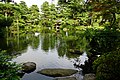 Shimizuen garden
 -
 Tsukioka Onsen


References
- ^ Shibata city official statistics(in Japanese)
- ^ a b Shibata official profile(in Japanese)
- ^ Shibata climate data
- ^ Shibata population statistics
- ^ a b c "International Exchange". List of Affiliation Partners within Prefectures. Council of Local Authorities for International Relations (CLAIR). Retrieved 1 July 2016.
External links
 Shibata travel guide from Wikivoyage
- Official Website (in Japanese)
| Niigata |
| |||
|---|---|---|---|---|
| Special cities | ||||
| Cities | ||||
| Districts | ||||
| Former Districts | ||||
| International | |
|---|---|
| National | |
| Geographic | |