
Soberanía National Park
| Soberanía National Park | |
|---|---|
| Parque Nacional Soberanía | |
.jpg) Soberanía National Park | |
 | |
| Location | Panamá and Colón Provinces, Panama |
| Nearest city | Panama City |
| Coordinates | 9°04′27″N 79°39′35″W / 9.0742977°N 79.6598053°W |
| Area | 55,000 acres (220 km2) |
| Established | 1980 |
| Website | Official website |
Soberanía National Park (Parque Nacional Soberanía) is a national park in Panama near the banks of the Panama Canal in the provinces of Panamá and Colón, some 25 kilometres (16 mi) from Panama City. The Chagres River runs through the park. Established as a national park in 1980, the park covers 55,000 acres (220 km2).[1]
Visitors to the Soberanía National Park can also explore the Las Cruces Trail (Camino de Cruces). This historical trail dates back to the 16th century and was used by the Spanish to transport gold. Parts of the trail are still lined with old stones that once marked the trail's original path.
The land that is now the Parque Municipal Summit was originally included in this park, but was turned over to Panama City in 1985.[2]
Birdwatching and fauna
The park is popular with birdwatchers due to its abundance of
The park is home to 100+ species of
.Numerous
Gallery
-
 An immature male white-tailed trogon near Panama Pipeline Road, Parque Nacional Soberania
 -
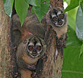 Panamanian night monkeys (Aotus zonalis) in Soberania National Park, Panama


References
- ^ Soberania National Park
- ^ "Summit: exuberance of flora and fauna". critica.com.pa. Critica-EPASA. Retrieved 7 May 2011.
- ^ Angehr G, Engleman D, Engleman L. 2008 A bird-finding guide to Panama. Cornell Univ. Press, Ithaca, New York, USA. 391 pp.
- ^ Kent Livezey, Birding Pipeline Panama, East Coast Tower, Costa del Este, Panama City, Panama 33192-4177
- ^ Friar, William "Moon Handbook Panama", First Edition, p. 114
External links
- Official website (Spanish)
| ||
| International | |
|---|---|
| National | |