
Panama Canal
| Panama Canal Canal de Panamá | |
|---|---|
 A schematic of the Panama Canal, illustrating the sequence of locks and passages | |
| Specifications | |
| Length | 82 km (51 miles) |
| Maximum boat length | 366 m (1,200 ft 9 in) |
| Maximum boat beam | 49 m (160 ft 9 in) (originally 28.5 m or 93 ft 6 in) |
| Maximum boat draft | 15.2 m (50 ft) |
| Maximum boat air draft | 57.91 m (190.0 ft) |
| Locks | 3 locks up, 3 down per transit; all three lanes (3 lanes of locks) |
| Status | Opened in 1914; expansion opened June 26, 2016 |
| Navigation authority | Panama Canal Authority |
| History | |
| Principal engineer | Ferdinand de Lesseps, John Findley Wallace (1904–1905), John Frank Stevens (1905–1907), George Washington Goethals (1907–1914) |
| Construction began | May 4, 1904 |
| Date completed | August 15, 1914 |
| Date extended | June 26, 2016 |
| Geography | |
| Start point | Atlantic Ocean |
| End point | Pacific Ocean |
| Connects to | Pacific Ocean from Atlantic Ocean and vice versa |

The Panama Canal (Spanish: Canal de Panamá) is an artificial 82-kilometre (51-mile) waterway in
The Panama Canal shortcut greatly reduces the time for ships to travel between the Atlantic and Pacific oceans, enabling them to avoid the lengthy, hazardous route around the southernmost tip of South America via the Drake Passage or Strait of Magellan. It is one of the largest and most difficult engineering projects ever undertaken.
Colombia, France, and later the United States controlled the territory surrounding the canal during construction. France began work on the canal in 1881, but stopped because of lack of investors' confidence due to engineering problems and a high worker mortality rate. The US took over the project in 1904 and opened the canal in 1914. The US continued to control the canal and surrounding Panama Canal Zone until the Torrijos–Carter Treaties provided for its handover to Panama in 1977. After a period of joint American–Panamanian control, the Panamanian government took control in 1999. It is now managed and operated by the Panamanian government-owned Panama Canal Authority.
The original locks are 33.5 meters (110 ft) wide and allow the passage of
Annual traffic has risen from about 1,000 ships in 1914, when the canal opened, to 14,702 vessels in 2008, for a total of 333.7 million
History
Early proposals in Panama

The earliest record regarding a canal across the Isthmus of Panama was in 1534, when Charles V, Holy Roman Emperor and King of Spain, ordered a survey for a route through the Americas in order to ease the voyage for ships traveling between Spain and Peru. The Spanish were seeking to gain a military advantage over the Portuguese.[3]
In 1668, the English physician and philosopher Sir Thomas Browne speculated in his encyclopedic work, Pseudodoxia Epidemica, that "some Isthmus have been eaten through by the Sea, and others cut by the spade: And if the policy would permit, that of Panama in America were most worthy the attempt: it being but few miles over, and would open a shorter cut unto the East Indies and China".[4]
Given the strategic location of Panama, and the potential of its narrow isthmus separating two great oceans, other trade links in the area were attempted over the years. One early example of this was ill-fated
Numerous canals were built in other countries in the late 18th and early 19th centuries. The success of the Erie Canal through central New York in the United States in the 1820s and the collapse of the Spanish Empire in Latin America resulted in growing American interest in building an inter-oceanic canal. Beginning in 1826, US officials began negotiations with Gran Colombia (present-day Colombia, Venezuela, Ecuador, and Panama), hoping to gain a concession to build a canal. Jealous of their newly gained independence and fearing domination by the more powerful United States, president Simón Bolívar and New Granada officials declined American offers. After the collapse of Gran Colombia, New Granada remained unstable under constant government intrigue.[citation needed]
Great Britain attempted to develop a canal in 1843. According to the
In 1846, the

In 1850, the United States began construction of the Panama Railroad (now called the Panama Railway) to cross the isthmus; it opened in 1855. This overland link became a vital piece of Western Hemisphere infrastructure, greatly facilitating trade. The later canal route was constructed parallel to it, as it had helped clear dense forests.[citation needed] An all-water route between the oceans was still the goal. In 1855, William Kennish, a Manx-born engineer working for the United States government, surveyed the isthmus and issued a report on a route for a proposed Panama Canal.[10] His report was published as a book entitled The Practicability and Importance of a Ship Canal to Connect the Atlantic and Pacific Oceans.[11][page needed]

In 1876,
French construction attempts, 1881–1899

The first attempt to construct a canal through what was then Colombia's province of Panama began on January 1, 1881. The project was inspired by the diplomat Ferdinand de Lesseps, who was able to raise considerable funds in France as a result of the huge profits generated by his successful construction of the Suez Canal.[14] Although the Panama Canal needed to be only 40 percent as long as the Suez Canal, it was much more of an engineering challenge because of the combination of tropical rain forests, debilitating climate, the need for canal locks, and the lack of any ancient route to follow.
Lesseps wanted a sea-level canal (like the Suez), but he visited the site only a few times, during the dry season which lasts only four months of the year.

Workers had to continually widen the main cut through the mountain at Culebra and reduce the angles of the slopes to minimize landslides into the canal.
In France, Lesseps kept the investment and supply of workers flowing long after it was obvious that the targets were not being met, but eventually the money ran out. The French effort went bankrupt in 1889 after reportedly spending US$287,000,000; an estimated 22,000 men died from disease and accidents, and the savings of 800,000 investors were lost.[17][22] Work was suspended on May 15, and in the ensuing scandal, known as the Panama affair, some of those deemed responsible were prosecuted, including Gustave Eiffel.[23] Lesseps and his son Charles were found guilty of misappropriation of funds and sentenced to five years' imprisonment. This sentence was later overturned, and the father, at age 88, was never imprisoned.[17]
In 1894, a second French company, the Compagnie Nouvelle du Canal de Panama, was created to take over the project. A minimal workforce of a few thousand people was employed primarily to comply with the terms of the Colombian Panama Canal concession, to run the
United States acquisition


At this time, the President and the Senate of the United States were interested in establishing a canal across the isthmus, with some favoring a
On January 22, 1903, the
Roosevelt changed tactics, based in part on the Mallarino–Bidlack Treaty of 1846, and actively supported the separation of Panama from Colombia. Shortly after recognizing Panama, he signed a treaty with the new Panamanian government under terms similar to the Hay–Herrán Treaty.[29]
On November 2, 1903, US warships blocked sea lanes against possible Colombian troop movements en route to put down the Panama rebellion. Panama declared independence on November 3, 1903. The United States quickly recognized the new nation.[30] This happened so quickly that by the time the Colombian government in Bogotá launched a response to the Panamanian uprising US troops had already entered the rebelling province. The Colombian troops dispatched to Panama were hastily assembled conscripts with little training. While these conscripts may have been able to defeat the Panamanian rebels, they would not have been able to defeat the US army troops that were supporting the Panamanian rebels. The reason an army of conscripts was sent was that it was the best response the Colombians could muster, as Colombia still was recovering from a civil war between Liberals and Conservatives from October, 1899, to November, 1902, known as the "Thousand Days War". The US was fully aware of these conditions and even incorporated them into the planning of the Panama intervention as the US acted as an arbitrator between the two sides. The peace treaty that ended the "Thousand Days War" was signed on the USS Wisconsin on November 21, 1902. While in port, the US also brought engineering teams to Panama with the peace delegation to begin planning the canal's construction before the US had even gained the rights to build the canal. All these factors would result in the Colombians being unable to put down the Panamanian rebellion and expel the United States troops occupying what today is the independent nation of Panama.[31]
On November 6, 1903, Philippe Bunau-Varilla, as Panama's ambassador to the United States, signed the Hay–Bunau-Varilla Treaty, granting rights to the United States to build and indefinitely administer the Panama Canal Zone and its defenses. This is sometimes misinterpreted as the "99-year lease" because of misleading wording included in article 22 of the agreement.[32] Almost immediately, the treaty was condemned by many Panamanians as an infringement on their country's new national sovereignty.[33][34] This would later become a contentious diplomatic issue among Colombia, Panama, and the United States.
President Roosevelt famously stated, "I took the Isthmus, started the canal and then left Congress not to debate the canal, but to debate me." Several parties in the United States called this an act of war on Colombia: The
In 1904, the United States purchased the French equipment and excavations, including the
In 1921, Colombia and the United States entered into the Thomson–Urrutia Treaty, in which the United States agreed to pay Colombia $25 million: $5 million upon ratification, and four $5 million annual payments, and grant Colombia special privileges in the Canal Zone. In return, Colombia recognized Panama as an independent nation.[40]
United States construction of the Panama canal, 1904–1914


The US formally took control of the canal property on May 4, 1904, inheriting from the French a depleted workforce and a vast jumble of buildings, infrastructure, and equipment, much of it in poor condition. A US government commission, the
On May 6, 1904, President Theodore Roosevelt appointed John Findley Wallace, formerly chief engineer and finally general manager of the Illinois Central Railroad, as chief engineer of the Panama Canal Project. Overwhelmed by the disease-plagued country and forced to use often dilapidated French infrastructure and equipment,[42] as well as being frustrated by the overly bureaucratic ICC, Wallace resigned abruptly in June 1905.[43] The ICC brought on a new chairman, Theodore P. Shonts, and a new chief engineer was appointed, John Frank Stevens, a self-educated engineer who had built the Great Northern Railroad.[44] Stevens was not a member of the ICC; he increasingly viewed its bureaucracy as a serious hindrance, bypassing the commission and sending requests and demands directly to the Roosevelt administration in Washington, DC.
One of Stevens' first achievements in Panama was in building and rebuilding the housing, cafeterias, hotels, water systems, repair shops, warehouses, and other infrastructure needed by the thousands of incoming workers. Stevens began the recruitment effort to entice thousands of workers from the United States and other areas to come to the Canal Zone to work. Workers from the Caribbean—called "Afro-Panamanians"—came in large numbers and many settled permanently. Stevens tried to provide accommodation in which the workers could work and live in reasonable safety and comfort. He also re-established and enlarged the railway, which was to prove crucial in transporting millions of tons of soil from the cut through the mountains to the dam across the Chagres River.

Colonel William C. Gorgas had been appointed chief sanitation officer of the canal construction project in 1904. Gorgas implemented a range of measures to minimize the spread of deadly diseases, particularly yellow fever and malaria, which had recently been shown to be mosquito-borne following the work of Cuban epidemiologist, Carlos Finlay and American pathologist, Walter Reed.[45] Investment was made in extensive sanitation projects, including city water systems, fumigation of buildings, spraying of insect-breeding areas with oil and larvicide, installation of mosquito netting and window screens, and elimination of stagnant water. Despite opposition from the commission (one member said his ideas were barmy), Gorgas persisted, and when Stevens arrived, he threw his weight behind the project. After two years of extensive work, the mosquito-spread diseases were nearly eliminated.[46] Despite the monumental effort, about 5,600 workers ended up dead via disease and accidents during the US construction phase of the canal.
Besides healthier and far better living conditions for the workers, another benefit given to American citizens working on the Canal was a medal for two years of service. Additional bars were added for each two-year period after that. Designed by
In 1905, a US engineering panel was commissioned to review the canal design, which had not been finalized. In January 1906 the panel, in a majority of eight to five, recommended to President Roosevelt a sea-level canal,
The construction of a canal with locks required the excavation of more than 17 million cu yd (13 million m3) of material over and above the 30 million cu yd (23 million m3) excavated by the French. As quickly as possible, the Americans replaced or upgraded the old, unusable French equipment with new construction equipment that was designed for a much larger and faster scale of work. 102 large, railroad-mounted
Between 1912 and 1914 there was a controversy about the tolls for the canal.[52]

Goethals replaces Stevens as chief engineer

In 1907, Stevens resigned as chief engineer.
Goethals divided the engineering and excavation work into three divisions: Atlantic, Central, and Pacific. The Atlantic Division, under Major
The Central Division, under Major David du Bose Gaillard of the United States Army Corps of Engineers, was assigned one of the most difficult parts: excavating the Culebra Cut through the continental divide to connect Gatun Lake to the Pacific Panama Canal locks.[56]

On October 10, 1913, President Woodrow Wilson sent a signal from the White House by telegraph which triggered the explosion that destroyed the Gamboa Dike. This flooded the Culebra Cut, thereby joining the Atlantic and Pacific oceans via the Panama Canal.[57] Alexandre La Valley (a floating crane built by Lobnitz & Company and launched in 1887) was the first self-propelled vessel to transit the canal from ocean to ocean. This vessel crossed the canal from the Atlantic in stages during construction, finally reaching the Pacific on January 7, 1914.[58] SS Cristobal (a cargo and passenger ship built by Maryland Steel, and launched in 1902 as SS Tremont) on August 3, 1914, was the first ship to transit the canal from ocean to ocean.[59]
The construction of the canal was completed in 1914, 401 years after Panama was first crossed overland by the Europeans in Vasco Núñez de Balboa's party of conquistadores. The United States spent almost $500 million (roughly equivalent to $15.2 billion in 2023)[60] to finish the project. This was by far the largest American engineering project to date. The canal was formally opened on August 15, 1914, with the passage of the cargo ship SS Ancon.[61]
The opening of the Panama Canal in 1914 caused a severe drop in traffic along Chilean ports due to shifts in maritime trade routes,[62][63][64] despite the closure of the canal for nearly seven months after a landslide in the Culebra Cut on September 18, 1915.[65] The burgeoning sheep farming business in southern Patagonia suffered a significant setback by the change in trade routes,[66] as did the economy of the Falkland Islands.[67]
Throughout this time,
In 1914, steam shovels from the Panama Canal were purchased and put to use in Chuquicamata copper mine of northern Chile.[68]
-
 A Marion steam shovel excavating the Panama Canal in 1908
 -
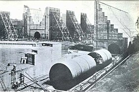 The Panama Canal locks under construction in 1910
 -
 The first ship to transit the canal at the formal opening, SS Ancon, passes through on 15 August 1914
 -
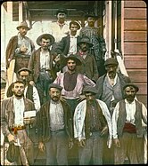 Spanish laborers working on the Panama Canal in early 1900s


Later developments

By the 1930s, water supply became an issue for the canal, prompting construction of the Madden Dam across the Chagres River above Gatun Lake. Completed in 1935, the dam created Madden Lake (later Alajuela Lake), which provides additional water storage for the canal.[69] In 1939, construction began on a further major improvement: a new set of locks large enough to carry the larger warships that the United States was building at the time and planned to continue building. The work proceeded for several years, and significant excavation was carried out on the new approach channels, but the project was canceled after World War II.[70][71]
After World War II, US control of the canal and the Canal Zone surrounding it became contentious; relations between Panama and the United States became increasingly tense. Many Panamanians felt that the Zone rightfully belonged to Panama; student protests were met by the fencing-in of the zone and an increased military presence there.

A decade later, in 1974, negotiations toward a settlement began and resulted in the Torrijos–Carter Treaties. On September 7, 1977, the treaty was signed by President of the United States Jimmy Carter and Omar Torrijos, de facto leader of Panama. This mobilized the process of granting the Panamanians free control of the canal so long as Panama signed a treaty guaranteeing the permanent neutrality of the canal. The treaty led to full Panamanian control effective at noon on December 31, 1999, and the Panama Canal Authority (ACP) assumed command of the waterway. The Panama Canal remains one of the chief revenue sources for Panama.[74][75]
Before this handover, the government of Panama held an international bid to negotiate a 25-year contract for operation of the
Canal
Layout
Panama Canal | ||||||||||||||||||||||||||||||||||||||||||||||||||||||||||||||||||||||||||||||||||||||||||||||||||||||||||||||||||||||||||||||||||||||||||||||||||||||||||||||||||||||||||||||||||||||||||||||||||||||||||||||||||||||||||||||||||||||||||||||||||||||||||||||||||||||||||||||||||||||||||||||||||||||||||||||||||||||||||||||||||||||||||||||||||||||||||||||||||||||
|---|---|---|---|---|---|---|---|---|---|---|---|---|---|---|---|---|---|---|---|---|---|---|---|---|---|---|---|---|---|---|---|---|---|---|---|---|---|---|---|---|---|---|---|---|---|---|---|---|---|---|---|---|---|---|---|---|---|---|---|---|---|---|---|---|---|---|---|---|---|---|---|---|---|---|---|---|---|---|---|---|---|---|---|---|---|---|---|---|---|---|---|---|---|---|---|---|---|---|---|---|---|---|---|---|---|---|---|---|---|---|---|---|---|---|---|---|---|---|---|---|---|---|---|---|---|---|---|---|---|---|---|---|---|---|---|---|---|---|---|---|---|---|---|---|---|---|---|---|---|---|---|---|---|---|---|---|---|---|---|---|---|---|---|---|---|---|---|---|---|---|---|---|---|---|---|---|---|---|---|---|---|---|---|---|---|---|---|---|---|---|---|---|---|---|---|---|---|---|---|---|---|---|---|---|---|---|---|---|---|---|---|---|---|---|---|---|---|---|---|---|---|---|---|---|---|---|---|---|---|---|---|---|---|---|---|---|---|---|---|---|---|---|---|---|---|---|---|---|---|---|---|---|---|---|---|---|---|---|---|---|---|---|---|---|---|---|---|---|---|---|---|---|---|---|---|---|---|---|---|---|---|---|---|---|---|---|---|---|---|---|---|---|---|---|---|---|---|---|---|---|---|---|---|---|---|---|---|---|---|---|---|---|---|---|---|---|---|---|---|---|---|---|---|---|---|---|---|---|---|---|---|---|---|---|---|---|---|---|---|---|---|---|---|---|---|---|---|---|---|---|---|---|---|---|---|---|---|---|
| ||||||||||||||||||||||||||||||||||||||||||||||||||||||||||||||||||||||||||||||||||||||||||||||||||||||||||||||||||||||||||||||||||||||||||||||||||||||||||||||||||||||||||||||||||||||||||||||||||||||||||||||||||||||||||||||||||||||||||||||||||||||||||||||||||||||||||||||||||||||||||||||||||||||||||||||||||||||||||||||||||||||||||||||||||||||||||||||||||||||
Legend
| ||||||||||||||||||||||||||||||||||||||||||||||||||||||||||||||||||||||||||||||||||||||||||||||||||||||||||||||||||||||||||||||||||||||||||||||||||||||||||||||||||||||||||||||||||||||||||||||||||||||||||||||||||||||||||||||||||||||||||||||||||||||||||||||||||||||||||||||||||||||||||||||||||||||||||||||||||||||||||||||||||||||||||||||||||||||||||||||||||||||
| ||||||||||||||||||||||||||||||||||||||||||||||||||||||||||||||||||||||||||||||||||||||||||||||||||||||||||||||||||||||||||||||||||||||||||||||||||||||||||||||||||||||||||||||||||||||||||||||||||||||||||||||||||||||||||||||||||||||||||||||||||||||||||||||||||||||||||||||||||||||||||||||||||||||||||||||||||||||||||||||||||||||||||||||||||||||||||||||||||||||


While globally the Atlantic Ocean is east of the isthmus and the Pacific is west, the general direction of the canal passage from the Atlantic to the Pacific is from northwest to southeast, because of the shape of the isthmus at the point the canal occupies. The Bridge of the Americas (Spanish: Puente de las Américas) at the Pacific side is about a third of a degree east of the Colón end on the Atlantic side.[78] Still, in formal nautical communications, the simplified directions "southbound" and "northbound" are used.
The canal consists of
- From the formal marking line of the Atlantic Entrance, one enters Limón Bay (Bahía Limón), a large natural harbor. The entrance runs 8.9 km (5+1⁄2 mi). It provides a deepwater port (free port).
- A 3.2 km (2 mi) channel forms the approach to the locks from the Atlantic side.
- The Gatun Locks, a three-stage flight of locks 2.0 km (1+1⁄4 mi) long, lifts ships to the Gatun Lake level, some 27 m (87 ft) above sea level.
- Gatun Lake, an artificial lake formed by the building of the Gatun Dam, carries vessels 24 km (15 mi) across the isthmus. It is the summit canal stretch, fed by the Gatun River and emptied by basic lock operations.
- From the lake, the Chagres River, a natural waterway enhanced by the damming of Gatun Lake, runs about 8.4 km (5+1⁄4 mi). Here the upper Chagres River feeds the high-level-canal stretch.
- The Culebra Cut slices 12.5 km (7+3⁄4 mi) through the mountain ridge, crosses the continental divide and passes under the Centennial Bridge.
- The single-stage Pedro Miguel Lock, which is 1.4 km (7⁄8 mi) long, is the first part of the descent with a lift of 9.4 m (31 ft).
- The artificial above sea level.
- The two-stage Miraflores Locks is 1.8 km (1+1⁄8 mi) long, with a total descent of 16 m (54 ft) at mid-tide.
- From the Miraflores Locks one reaches Balboa harbor, again with multimodal exchange provision (here the railway meets the shipping route again). Nearby is Panama City.
- From this harbor an entrance/exit channel leads to the Pacific Ocean (Gulf of Panama), 13.3 km (8+1⁄4 mi) from the Miraflores Locks, passing under the Bridge of the Americas.
Thus, the total length of the canal is 80 km (50 mi). In 2017 it took ships an average of 11.38 hours to pass between the canal's two outer locks.[80]
Gatun Lake

Created in 1913 by damming the Chagres River, the Gatun Lake is a key part of the Panama Canal, providing the millions of liters of water necessary to operate its locks each time a ship passes through. At time of formation, Gatun Lake was the largest human-made lake in the world.
Lock size
For its first century, the width and length of ships that may transit the canal was limited by the Pedro Miguel Locks; their
Initially the locks at Gatun were designed to be 28.5 m (94 ft) wide. In 1908, the United States Navy requested that the width be increased to at least 36 m (118 ft) to allow the passage of large warships. A compromise was made and the locks were built 33.53 m (110.0 ft) wide. Each lock is 320 m (1,050 ft) long, with the walls ranging in thickness from 15 m (49 ft) at the base to 3 m (9.8 ft) at the top. The central wall between the parallel locks at Gatun is 18 m (59 ft) thick and over 24 m (79 ft) high. The steel lock gates measure an average of 2 m (6.6 ft) thick, 19.5 m (64 ft) wide, and 20 m (66 ft) high.[83]
Panama Canal pilots were initially unprepared to handle the flight decks of aircraft carriers, which protrude beyond the hull on either side of the ship. When USS Saratoga made her first trip through the Gatun Locks in 1928, the ship knocked over all the concrete lamp posts along the canal.[84]
In 2016, a decade-long expansion project created larger locks, allowing bigger ships to transit through deeper and wider channels.[85] The allowed dimensions of ships using these locks increased by 25 percent in length, 51 percent in beam, and 26 percent in draft, as defined by Neopanamax metrics.[86]
Tolls

As with a toll road, vessels transiting the canal must pay tolls. Tolls for the canal are set by the Panama Canal Authority and are based on vessel type, size, and the type of cargo.[87]
For
Passenger vessels in excess of 30,000 tons (PC/UMS) pay a rate based on the number of berths, that is, the number of passengers that can be accommodated in permanent beds. Since April 1, 2016, the per-berth charge is $111 for unoccupied berths and $138 for occupied berths in the Panamax locks. Starting in 2007, this fee has greatly increased the tolls for such ships.[88] Passenger vessels of less than 30,000 tons or less than 33 tons per passenger are charged according to the same per-ton schedule as are freighters. Almost all major cruise ships have more than 33 tons per passenger; the rule of thumb for cruise line comfort is generally given as a minimum of 40 tons per passenger.
Most other types of vessels pay a toll per PC/UMS net ton, in which one "ton" is actually a volume of 100 cubic feet (2.83 m3). (The calculation of tonnage for commercial vessels is quite complex.) As of fiscal year 2016[update], this toll is US$5.25 per ton for the first 10,000 tons, US$5.14 per ton for the next 10,000 tons, and US$5.06 per ton thereafter. As with container ships, reduced tolls are charged for freight ships "in ballast", $4.19, $4.12, $4.05 respectively.
On April 1, 2016, a more complicated toll system was introduced, having the neopanamax locks at a higher rate in some cases, natural gas transport as a new separate category and other changes.[89] As of October 1, 2017, there are modified tolls and categories of tolls in effect.[90] Small (less than 125 ft) vessels up to 583 PC/UMS net tons when carrying passengers or cargo, or up to 735 PC/UMS net tons when in ballast, or up to 1,048 fully loaded displacement tons, are assessed minimum tolls based upon their length overall, according to the following table (as of April 29, 2015):
| Length of vessel | Toll |
|---|---|
| Up to 15.240 meters (50 ft) | US$800 |
| From 15.240 to 24.384 meters (50 to 80 ft) | US$1,300 |
| From 24.384 to 30.480 meters (80 to 100 ft) | US$2,000 |
| More than 30.480 meters (100 ft) | US$3,200 |
| INTRA MARITIME CLUSTER – Local Tourism More than 24.384 meters (80 ft) |
US$2,000 plus $72/TEU |
Morgan Adams of Los Angeles, California, holds the distinction of paying the first toll received by the U.S. government for the use of the Panama Canal by a pleasure boat. His boat Lasata passed through the Zone on August 14, 1914. The crossing occurred during a 10,000-kilometer (6,000-mile) sea voyage from Jacksonville, Florida, to Los Angeles in 1914.[91]
The most expensive regular toll for canal passage to date was charged on April 14, 2010, to the cruise ship
The lowest toll ever paid was 36 cents (equivalent to $6.39 in 2023), by American Richard Halliburton who swam the Panama Canal in 1928.[96]
Issues leading to expansion

Efficiency and maintenance
Opponents to the 1977
Increasing volumes of imports from Asia, which previously landed on US West Coast ports, are now passing through the canal to the American East Coast.[101] The total number of ocean-going transits increased from 11,725 in 2003 to 13,233 in 2007, falling to 12,855 in 2009. (The canal's fiscal year runs from October through September.)[102] This has been coupled with a steady rise in average ship size and in the numbers of Panamax vessels passing through the canal, so that the total tonnage carried rose from 227.9 million PC/UMS tons in fiscal year 1999 to a then record high of 312.9 million tons in 2007, and falling to 299.1 million tons in 2009.[78][102] Tonnage for fiscal 2013, 2014 and 2015 was 320.6, 326.8 and 340.8 million PC/UMS tons carried on 13,660, 13,481 and 13,874 transits respectively.[103]


In the first decade after the transfer to Panamanian control, the Panama Canal Authority (ACP) invested nearly US$1 billion in widening and modernizing the canal, with the aim of increasing capacity by 20 percent.[104] The ACP cites a number of major improvements, including the widening and straightening of the Culebra Cut to reduce restrictions on passing vessels, the deepening of the navigational channel in Gatun Lake to reduce draft restrictions and improve water supply, and the deepening of the Atlantic and Pacific entrances to the canal. This is supported by new equipment, such as a new drill barge and suction dredger, and an increase of the tug boat fleet by 20 percent. In addition, improvements have been made to the canal's operating machinery, including an increased and improved tug locomotive fleet, the replacement of more than 16 km (10 mi) of locomotive track, and new lock machinery controls. Improvements have been made to the traffic management system to allow more efficient control over ships in the canal.[105]
In December 2010, record-breaking rains caused a 17-hour closure of the canal; this was the first closure since the
Capacity
The canal handles more vessel traffic than had ever been envisioned by its builders. In 1934 it was estimated that the maximum capacity of the canal would be around 80 million tons per year;[112] as noted above, canal traffic in 2015 reached 340.8 million tons of shipping.
To improve capacity, a number of improvements have been made to maximize the use of the locking system:[113]
- Implementation of an enhanced locks lighting system;
- Construction of two tie-up stations in Culebra Cut;
- Widening Culebra Cut from 192 to 218 meters (630 to 715 ft);
- Improvements to the tugboat fleet;
- Implementation of the carousel lockage system in Gatun locks;
- Development of an improved vessel scheduling system;
- Deepening of Gatun Lake navigational channels from 10.4 to 11.3 meters (34 to 37 ft) PLD;
- Modification of all locks structures to allow an additional draft of about 0.30 meters (1 ft);
- Deepening of the Pacific and Atlantic entrances;
- Construction of a new spillway in Gatun, for flood control.
These improvements enlarged the capacity from 300 million PCUMS (2008) to 340 PCUMS (2012). These improvements were started before the new locks project, and are complementary to it.
Competition

The canal faces increasing competition from other quarters. Because canal tolls have risen as ships have become larger, some critics[115] have suggested that the Suez Canal is now a viable alternative for cargo between Asia and the US East Coast.[116] The Panama Canal, however, continues to serve more than 144 of the world's trade routes and the majority of canal traffic comes from the "all-water route" from Asia to the US East and Gulf Coasts.[117]
An alternative route through
The increasing rate of melting of ice in the Arctic Ocean has led to speculation that the Northwest Passage or Arctic Bridge may become viable for commercial shipping. This route would save 9,300 km (5,800 mi) on the route from Asia to Europe compared with the Panama Canal, possibly leading to a diversion of some traffic to that route. However, such a route is beset by unresolved territorial issues and would still hold significant problems owing to ice.[123]
Water issues
.png)
Gatun Lake is filled with rainwater, and the lake accumulates excess water during wet months. For the old locks, water is lost to the oceans at a rate of 101,000 m3 (26.7 million US gal; 81.9 acre⋅ft) per downward lock movement.[124] The ship's submerged volume is not relevant to this amount of water.
During the dry season, when there is less rainfall, there is also a shortage of water in Gatun Lake.[125]
As a signatory to the 2000 United Nations Global Compact and member of the World Business Council for Sustainable Development, the ACP developed an environmentally and socially sustainable program for expansion, which protects the aquatic and terrestrial resources of the canal watershed. The expansion uses three water-saving basins at each new lock, diminishing water loss. It also preserves freshwater resources along the waterway by reusing 60 percent of water from the basins in the locks in each transit.[126]
The mean sea level at the Pacific side is about 20 cm (8 in) higher than that of the Atlantic side due to differences in ocean conditions such as water density and weather.[127]
The 2015-16 fiscal year was one of the driest periods on record, restricting ships passage;[128] 2019 was the fifth driest year for 70 years. Temperature rise has also caused an increase in evaporation.[129] In normal times, 36 ships can transit the canal each day, but in early December 2023, ships were backing up because only 22 ships per day could transit due to low water levels.[130] In January 2024, 24 ships per day were allowed to transit.[131]
Third set of locks project (expansion)

As demand is rising for efficient global shipping of goods, the canal is positioned to be a significant feature of world shipping for the foreseeable future. However, changes in shipping patterns—particularly the increasing numbers of larger-than-Panamax ships—necessitated changes to the canal for it to retain a significant market share. In 2006 it was anticipated that by 2011, 37 percent of the world's container ships would be too large for the present canal, and hence a failure to expand would result in a significant loss of market share. The maximum sustainable capacity of the original canal, given some relatively minor improvement work, was estimated at 340 million PC/UMS tons per year; it was anticipated that this capacity would be reached between 2009 and 2012. Close to 50 percent of transiting vessels were already using the full width of the locks.[132]
An enlargement scheme to allow for a greater number of transits and the ability to handle larger ships, similar to the

The expansion plan had two new flights of locks built parallel to, and operated in addition to, the old locks: one east of the existing Gatun locks, and one southwest of the Miraflores locks, each supported by approach channels. Each flight ascends from sea level directly to the level of Gatun Lake; the existing two-stage ascent at Miraflores and Pedro Miguel locks was not replicated. The new lock chambers feature sliding gates, doubled for safety, and are 427 m (1,400 ft) long, 55 m (180 ft) wide, and 18.3 m (60 ft) deep. This allows the transit of vessels with a beam of up to 49 m (160 ft), an overall length of up to 366 m (1,200 ft) and a draft of up to 15 m (49 ft), equivalent to a container ship carrying around 12,000 containers, each 6.1 m (20 ft) in length (TEU).
The new locks are supported by new approach channels, including a 6.2 km (3.9 mi) channel at Miraflores from the locks to the Gaillard Cut, skirting Miraflores Lake. Each of these channels are 218 m (720 ft) wide, which will require post-Panamax vessels to navigate the channels in one direction at a time. The Gaillard Cut and the channel through Gatun Lake were widened to at least 280 m (920 ft) on the straight portions and at least 366 m (1,200 ft) on the bends. The maximum level of Gatun Lake was raised from 26.7 to 27.1 m (88 to 89 ft).
Each flight of locks is accompanied by nine water reuse basins (three per lock chamber), each basin being about 70 m (230 ft) wide, 430 m (1,400 ft) long and 5.50 m (18 ft) deep. These gravity-fed basins allow 60 percent of the water used in each transit to be reused; the new locks consequently use 7 percent less water per transit than each of the existing lock lanes. The deepening of Gatun Lake and the raising of its maximum water level also provide capacity for significantly more water storage. These measures are intended to allow the expanded canal to operate without constructing new reservoirs.
The estimated cost of the project is US$5.25 billion. The project was designed to allow for an anticipated growth in traffic from 280 million PC/UMS tons in 2005 to nearly 510 million PC/UMS tons in 2025. The expanded canal will have a maximum sustainable capacity of about 600 million PC/UMS tons per year. Tolls will continue to be calculated based on vessel tonnage, and in some cases depend on the locks used.
An article in the February 2007 issue of Popular Mechanics magazine described the engineering aspects of the expansion project.[137] There is also a follow-up article in the February 2010 issue of Popular Mechanics.[138]
On September 3, 2007, thousands of
It was announced in July 2009 that the Belgian dredging company
In January 2014, a contract dispute threatened the progress of the project.[147][148] There was a delay of less than two months however, with work by the consortium members reaching goals by June 2014.[149][150]
In June 2015, flooding of the new locks began: first on the Atlantic side, then on the Pacific; by then, the canal's re-inauguration was slated for April 2016.[151][152][153] On March 23, 2016, the expansion inauguration was set for June 26, 2016.[154]
The new locks opened for commercial traffic on June 26, 2016, and the first ship to cross the canal using the third set of locks was a modern
The total cost is unknown since the expansion's contractors are seeking at least an additional US$3.4 billion from the canal authority due to excess expenses.[155]
Environmental and ecological consequences
In 1978, it was published that "clearing the forest in the watershed might kill the canal".[156] In 1985, the forested portion had dropped to 30%.[157] As of 2000, deforestation through growth of human population, land degradation, erosion, and overhunting continued to be threats to the ecosystem of the Panama canal watershed.[156] Deforestation causes erosion, raising the bottom of the Gatun and Alajuala lakes lowering their water holding capacity.[157] Ship traffic routinely contaminates the water; in 1986, a crude oil spill east of the Caribbean entrance to the Panama Canal killed plants and invertebrates.[158]
Especially with the 2016 expansion, invasive species can travel faster, either on the hulls of ships or in
Routes competing with the canal
Nicaragua canal
On July 7, 2014, Wang Jing, chairman of the HK Nicaragua Canal Development Investment Co. Ltd. (HKND Group) advised that a route for Nicaragua's proposed canal had been approved. The construction work was projected by HKND to begin in 2014 and take 5 years,[160] although there had been little progress before the project's abandonment.[161] The Nicaraguan parliament approved plans for the 280 km (174 mi) canal through Nicaragua and according to the deal, the company would have been responsible for operating and maintaining the canal for a 50-year period. By May 2017, no concrete action had been reportedly taken constructing the canal and further doubts were expressed about its financing.[162] In February 2018, analysts widely viewed the project as defunct, though the head of the project insisted work was on-going and HKND retained the legal rights to the concession for the canal as well as side projects. Despite HKND vanishing in April 2018,[163] the Nicaraguan government indicates that it will continue with the 908 km2 (351 sq mi) dry land expropriations within Nicaragua, under land expropriation Canal Law 840.
Colombia rail link
In 2011, Colombia's then-president Juan Manuel Santos announced a proposal for a 220 km (137 mi) railway between Colombia's Pacific and Caribbean coasts.[164][165] However, in 2015 the director of the Colombia-China Chamber of Commerce said the proposal "was mentioned in 2011 and subsequently had minimal relevance".[166]
Northwest Passage
Climate change has thinned much of the ice that in the past made this route between the Atlantic and Pacific oceans impassable. Satellite navigation can help monitor location of the ice which remains, further easing transit. A few ships have successfully crossed the previously impossible route since 2000.[167]
Interoceanic Corridor of the Isthmus of Tehuantepec
Since 2019, Mexico has been building a corridor of its own, known as the Interoceanic Corridor of the Isthmus of Tehuantepec (CIIT, by its initials in Spanish), which will use primarily a railway, the
Other projects
.png)
Individuals, companies, and governments have explored the possibility of constructing deep water ports and rail links connecting coasts as a "dry canal" in Guatemala, Costa Rica, and El Salvador/Honduras. However, plans to construct these sea-rail-sea links have yet to materialize.[175]
Master Key to Panama Canal and Honorary Pilots
During the last one hundred years, the Panama Canal Authority has granted membership in the "Esteemed Order of Bearers of the Master Key of the Panama Canal" and appointed a few "Honorary Lead Pilots" to employees, captains and dignitaries.
See also
- Ajax (crane barge)
- Canal des Deux Mers
- Canal Zone Police
- Corinth Canal
- List of waterways
- Panama Canal Zone
- Suez Canal
References
- ^ "Panama Canal Traffic—Years 1914–2010". Panama Canal Authority. Archived from the original on December 30, 2010. Retrieved January 25, 2011.
- ^ "Seven Wonders". American Society of Civil Engineers. Archived from the original on August 2, 2010. Retrieved February 21, 2011.
- ^ "A History of the Panama Canal: French and American Construction Efforts". Panama Canal Authority. Archived from the original on December 15, 2014. Retrieved September 3, 2007.; Chapter 3, Some Early Canal Plans Archived January 2, 2015, at the Wayback Machine
- ^ Browne, Sir Thomas (1668). "Book 6, chapter 8". On the River Nile (4th ed.). Archived from the original on November 19, 2021. Retrieved January 10, 2022.
- ^ "Darien Expedition". Archived from the original on July 19, 2011. Retrieved September 3, 2007.
- ISBN 0801839580.
- ISBN 978-0-8283-1714-6.
- ^ [1][dead link]
- ISBN 9780375415425.
- ^ A.W. Moore (1901). "William Kennish (b. 1799, d. 1862)". Manx Worthies or Biographies of Notable Manx Men and Women. Douglas, Isle of Man: S. K. Broadbent. p. 118. Archived from the original on June 28, 2015. Retrieved February 8, 2010 – via isle-of-man.com.
- ^ Kelley, Frederick M.; Kennish, William; Serrell, Edward Wellman (1855). The Practicability and Importance of a Ship Canal to Connect the Atlantic and Pacific Oceans. Archived from the original on July 28, 2020. Retrieved February 27, 2016.
- ISBN 9782843946684. Archivedfrom the original on October 25, 2021. Retrieved January 10, 2022.
- ^ McCullough 1977, pp. 58–59.
- ^ McCullough 1977, p. 125.
- ^ McCullough 1977, pp. 103–123.
- ^ Cadbury 2003, pp. 201–204.
- ^ a b c Avery, Ralph E. (1913). "The French Failure". America's Triumph in Panama. Chicago, IL: L.W. Walter Company. Archived from the original on July 28, 2017. Retrieved January 10, 2022.
- ISBN 0-00-653235-7.
- ^ "The Panama Canal: Explorers, pirates, scientists and engineers – University of Michigan News". umich.edu. April 18, 2007. Archived from the original on July 1, 2016. Retrieved April 20, 2016.
- ISBN 978-1-61060-586-1.
- ^ "Read our history: The French Canal Construction". Panama Canal Authority. Archived from the original on December 15, 2014. Retrieved September 3, 2007.
- ^ Cadbury 2003, p. 262.
- ^ McCullough 1977, p. 224.
- ^ Cadbury 2003, p. 261.
- ^ Panama Canal Official Site – History – https://www.pancanal.com/eng/history/history/ Archived September 10, 2021, at the Wayback Machine select chapter The French Canal Construction – accessed 9/11/2021
- ^ McCullough 1977, pp. 305–328.
- ^ "Hay-Herrán Treaty". U-S-history.com. November 18, 1903. Archived from the original on February 14, 2012. Retrieved October 24, 2010.
- ^ "Hay-Herran Treaty (1903)".
- ISBN 9781848132146.
- ^ McCullough 1977, pp. 361–386.
- ISBN 978-1-118-77248-5.
- ^ "Avalon Project—Convention for the Construction of a Ship Canal (Hay-Bunau-Varilla Treaty), November 18, 1903". Avalon.law.yale.edu. Archived from the original on November 4, 2011. Retrieved October 24, 2010.
- ^ "September 07, 1977 : Panama to control canal". History.com. 2010. Archived from the original on April 10, 2015. Retrieved April 4, 2015.
- ISBN 9780191509070. Archivedfrom the original on March 23, 2017. Retrieved April 4, 2015.
- ^ Delano, Anthony (November 9, 2016). "America's devious dream: Roosevelt and the Panama Canal". HistoryExtra. Retrieved March 6, 2024.
- ^ Colby, Gerard (January 1, 2020). "William S. Culbertson and The Search for The Geopolitical Imperium". Graduate College Dissertations and Theses.
- ^ Huffman, Alan (August 15, 2014). "Panama Canal's 48 Miles To An 'American Century'". International Business Times. Retrieved March 6, 2024.
- ^ Hanson, David C. "Theodore Roosevelt and the Panama Canal" (PDF). Virginia Western Community College. Archived from the original (PDF) on February 1, 2014. Retrieved January 21, 2014.
- ^ Committee On Appropriations, United States. Congress. House (1913). "Col. Goethals testimony". The Panama Canal Congressional Hearings 1909. p. 15. Archived from the original on January 10, 2022. Retrieved December 26, 2011.
- ^ "U.S. agrees to transfer Panama Canal to Panama". History.com. Archived from the original on November 27, 2020. Retrieved July 28, 2021.
- ^ McCullough 1977, pp. 273–274.
- ^ McCullough 1977, p. 440.
- ^ McCullough 1977, p. 457.
- ^ McCullough 1977, pp. 459–462.
- ^ McCullough 1977, pp. 405–426.
- ^ McCullough 1977, pp. 466–468.
- ^ The Panama Canal Service Medal - The "Junk" Medal
- ^ Roosevelt Medal Holders
- ^ Chisholm, Hugh, ed. (1911). . Encyclopædia Britannica. Vol. 20 (11th ed.). Cambridge University Press. p. 670.
- ^ Panama Canal Official Site – https://www.pancanal.com/eng/history/history/ Archived September 10, 2021, at the Wayback Machine select chapter The French Canal Construction – accessed 9/11/2021
- ^ McCullough 1977, pp. 485–489.
- JSTOR 1891013.
- ^ McCullough 1977, pp. 503–508.
- ^ "The Panama Canal: Writings of the U. S. Army Corps of Engineers Officers Who Conceived and Built It". p. 1. Archived from the original on April 8, 2013. Retrieved May 1, 2023.
- ^ McCullough 1977, pp. 540–542.
- ^ "Col. David D.B. Gaillard". www.czbrats.com. Retrieved May 1, 2023.
- ^ "Wilson blows up last big barrier in Panama Canal". Chicago Tribune. Chicago. October 11, 1913. p. 1. Archived from the original on November 25, 2015. Retrieved November 24, 2015.
- ^ McCullough 1977, p. 607.
- ^ McCullough 1977, p. 609.
- ^ 1634–1699: McCusker, J. J. (1997). How Much Is That in Real Money? A Historical Price Index for Use as a Deflator of Money Values in the Economy of the United States: Addenda et Corrigenda (PDF). American Antiquarian Society. 1700–1799: McCusker, J. J. (1992). How Much Is That in Real Money? A Historical Price Index for Use as a Deflator of Money Values in the Economy of the United States (PDF). American Antiquarian Society. 1800–present: Federal Reserve Bank of Minneapolis. "Consumer Price Index (estimate) 1800–". Retrieved February 29, 2024.
- ^ "Read our history: American Canal Construction". Panama Canal Authority. Archived from the original on December 15, 2014. Retrieved September 3, 2007.
- ^ John Lawrence, Rector (2005), The History of Chile, p. xxvi
- ^ Martinic Beros, Mateo (2001), "La actividad industrial en Magallanes entre 1890 y mediados del siglo XX", Historia, 34, archived from the original on July 2, 2017, retrieved July 4, 2014
- from the original on October 25, 2014.
- ^ "A Century of Progress: A Century of Slides". The Land Divided, The World United. Kansa City, Missouri: Linda Hall Library. Archived from the original on May 25, 2022. Retrieved November 13, 2022.
- Biblioteca Nacional de Chile, archivedfrom the original on October 19, 2013, retrieved June 30, 2013
- S2CID 154575728.
- ^ Barros M., María Celia (April 6, 2015). "Una mina centenaria". mch.cl (in Spanish). Retrieved July 2, 2022.
- ^ "Panama Dam to Aid Canal Traffic". Popular Mechanics. Bonnier Corporation. January 1930. p. 25. Archived from the original on July 28, 2020. Retrieved February 27, 2016.
- ^ "Enlarging the Panama Canal". czbrats.com. Archived from the original on April 5, 2016. Retrieved January 7, 2006.
- ^ "Presentation on the Third Locks Project – Panama Canal Zone". czimages.com. Archived from the original on February 14, 2017. Retrieved January 7, 2006.
- ^ "The Martyrs of 1964". www.czbrats.com. Retrieved May 1, 2023.
- ^ "MILESTONES: 1953–1960".
- ^ "Here's Why The Panama Canal Expansion Has Everyone Excited". TheHuffingtonPost.com. July 11, 2016. Archived from the original on September 28, 2017. Retrieved February 20, 2020.
The Canal previously accounted for about 15 percent of the country's GDP
- ^ "A plan to unlock prosperity". The Economist. December 3, 2009. Archived from the original on July 8, 2017. Retrieved April 17, 2017.
- ISSN 0099-9660. Retrieved March 12, 2022.
- ^ a b "Hydroelectric Plants in Panama". July 5, 2015. Retrieved June 26, 2016.
- ^ a b "Panama Canal Traffic—Fiscal Years 2002–2004" (PDF). Panama Canal Authority. Archived from the original (PDF) on December 1, 2005. Retrieved September 3, 2007.
- ^ "Historical Map & Chart Project". NOAA. Archived from the original on September 5, 2007. Retrieved September 3, 2007.
- ^ "Annual Report 2017" (PDF). Panama Canal Authority. Archived (PDF) from the original on April 3, 2021. Retrieved April 2, 2021.
- ^ "Infosheet No. 30: Modern ship size definitions" (PDF). Lloyd's Register. July 26, 2007. Archived from the original (PDF) on February 24, 2012.
- ^ "Professional Resources in Science and Mathematics (PRISM)". Retrieved May 1, 2023.
- ^ "The Panama Canal". Archived from the original on May 15, 2008. Retrieved October 18, 2007.
- ^ Pride, Alfred M. (1986). "Pilots, Man Your Planes". Proceedings. Supplement (April). United States Naval Institute: 28–35.
- ^ a b c Zamorano, Juan; Martinez, Kathia (June 26, 2016). "Panama Canal opens $5B locks, bullish despite shipping woes". The Big Story. Associated Press. Archived from the original on June 26, 2016. Retrieved March 6, 2017.
- ^ "New Panamax publication by ACP" (PDF). November 2006. Archived from the original (PDF) on May 6, 2009. Retrieved October 24, 2010.
- ^ "Marine Tariff". Panama Canal Authority. Archived from the original on August 2, 2017. Retrieved June 3, 2014.
- ^ Panama Canal Toll Table http://www.pancanal.com/eng/op/tariff/1010-0000-Rev20160414.pdf[permanent dead link]
- ^ "Maritime Services - PanCanal.com". www.pancanal.com. Archived from the original on August 2, 2017. Retrieved June 3, 2014.
- ^ "Toll Tariffs Approved By Cabinet Council And Published On The Official Gazzette. Implementation: October 1, 2017 (Fy 2018)" (PDF). Panama Canal Authority. Archived (PDF) from the original on September 27, 2017. Retrieved September 26, 2017.
- ^ "The Panama Canal - All You Need to Know". Panama Passion. July 11, 2020. Retrieved December 13, 2023.
- ^ "US Today Travel: Panama Canal Facts". USA Today. Archived from the original on February 17, 2013. Retrieved August 3, 2012.
- ^ "ACP rectifica récord en pago de peaje" (in Spanish). La Prensa. June 24, 2008. Archived from the original on August 16, 2009. Retrieved August 8, 2009.
- ^ "Récord en pago de peajes y reserva". La Prensa. Ediciones.prensa.com. April 24, 2007. Archived from the original on October 6, 2014. Retrieved July 13, 2009.
- ^ "Cupo de subasta del Canal alcanza récord. La Prensa. Sección Economía & Negocios. Edición 25 August 2006 in Spanish". Mensual.prensa.com. Archived from the original on August 3, 2009. Retrieved July 13, 2009.
- ^ "About ACP - PanCanal.com". Panama Canal Authority. Archived from the original on November 27, 2015. Retrieved October 8, 2014.
- ^ Cullen, Bob (March 2004). "Panama Rises". Smithsonian Magazine. Smithsonian Institution. Archived from the original on September 13, 2012. Retrieved April 30, 2012.
- ^ "ACP 2005 Annual Report" (PDF). Panama Canal Authority. 2005. Archived (PDF) from the original on May 6, 2009. Retrieved July 9, 2010.
- ^ "News—PanCanal.com; Panama Canal Authority Announces Fiscal Year 2008 Metrics". Panama Canal Authority. October 24, 2008. Archived from the original on May 7, 2009. Retrieved July 9, 2010.
- ^ "News—PanCanal.com; Panama Canal Authority Announces Fiscal Year 2009 Metrics". Panama Canal Authority. October 30, 2009. Archived from the original on June 11, 2011. Retrieved July 9, 2010.
- ^ Lipton, Eric (November 22, 2004). "New York Port Hums Again, With Asian Trade". The New York Times. Archived from the original on March 7, 2005.
- ^ a b "ACP 2009 Annual Report" (PDF). Panama Canal Authority. 2009. Archived (PDF) from the original on November 3, 2011. Retrieved July 9, 2010.
- ^ "Panama Canal Traffic—Fiscal Years 2013 through 2015" (PDF). Panama Canal Authority. Archived from the original (PDF) on July 19, 2016.
- ^ Nettleton, Steve (2000). "Transfer heavy on symbolism, light on change". CNN Interactive. Archived from the original on December 18, 2008.
- ^ "9 Facts about the Panama Canal Expansion – Infographic". Mercatrade. Archived from the original on October 20, 2014. Retrieved October 28, 2014.
- ^ "Panama Canal reopens after temporary closure". BBC News. December 9, 2010. Archived from the original on October 17, 2018. Retrieved December 13, 2010.
- ^ "The Press Association: Panama flooding displaces thousands". December 12, 2010. Retrieved December 12, 2010.[dead link]
- ^ "NOTICIAS PANAMÁ—PERIÓDICO LA ESTRELLA ONLINE: Gobierno abrirá parcialmente Puente Centenario; Corredores serán gratis [Al Minuto]". December 13, 2010. Archived from the original on December 16, 2010. Retrieved December 13, 2010.
- ^ "Rain Causes Panama Canal Bridge To Collapse". digtriad.com. December 12, 2010. Archived from the original on May 1, 2013. Retrieved July 8, 2012.
- ^ "Entrance to Panama Canal Bridge Closed due to Rain Damage". December 13, 2010. Archived from the original on December 15, 2010. Retrieved December 13, 2010.
- ^ "Aftermath of Panama flooding hits transport and finances—rain continues". December 13, 2010. Archived from the original on December 16, 2010. Retrieved December 13, 2010.
- ^ Mack, Gerstle (1944). The Land Divided—A History of the Panama Canal and other Isthmian Canal Projects. Archived from the original on May 1, 2013. Retrieved January 7, 2006.
- ^ "Proposal for the Expansion of the Panama Canal" (PDF). Panama Canal Authority. April 24, 2006. p. 45. Archived from the original (PDF) on July 21, 2011.
- ^ "Panama Canal expansion will allow transit of larger ships with greater volumes". Today in Energy. EIA. September 17, 2014. Archived from the original on April 25, 2019. Retrieved April 25, 2019.
- ^ Jackson, Eric (2007). Shipping industry complains about PanCanal toll hikes. Archived from the original on April 18, 2010.
- ^ "Maersk Line to Dump Panama Canal for Suez as Ships Get Bigger". Bloomberg News. May 11, 2013. Archived from the original on March 10, 2021. Retrieved December 24, 2013.
- ^ "Microsoft Word - Panama_Canal_Phase_I_Report_-_20Nov2013.docx" (PDF).
- ^ De Cordoba, Jose (June 13, 2013). "Nicaragua Revives Its Canal Dream". Wall Street Journal. Archived from the original on November 11, 2013. Retrieved January 10, 2022.
- ^ "Incertidumbres financieras desvanecen sueño de canal en Nicaragua". El Financiero (in Spanish). AFP. February 21, 2018.
- ^ Cropsey, Seth (April 9, 2018). "China sets its sights on South America". The American Interest.
China has abandoned its attempts to construct a Nicaraguan Canal to compete with its Panamanian counterpart.
- ^ Goldberg, Beverly (August 27, 2018). "Is the Nicaraguan mega-canal failure good news for indigenous communities?". Open Democracy. Archived from the original on August 28, 2018. Retrieved April 10, 2023.
- ^ "Ex-Billionaire Abandons Office in Prime Hong Kong Tower". Bloomberg.com. April 26, 2018. Retrieved May 1, 2023.
- ^ Sevunts, Levon (June 12, 2005). "Northwest Passage redux". The Washington Times. Archived from the original on December 26, 2008. Retrieved April 20, 2009. See also: Comte, Michel (December 22, 2005). "Conservative Leader Harper Asserts Canada's Arctic Claims". DefenceNews.com (Agence France-Presse). Retrieved February 23, 2006.[permanent dead link]
- ^ "Physical characteristics of the waterway". Panama Canal Authority. 2001. Archived from the original on October 14, 2001. Retrieved August 26, 2023.
How much water is required to fill a lock chamber? Each lock chamber requires 101,000 cubic meters of water. An average of 52 million gallons of fresh water are used.
- from the original on January 2, 2020. Retrieved January 2, 2020.
- .
- ^ "Frequently Asked Questions". psmsl.org. Retrieved May 1, 2023.
- ISSN 0190-8286. Retrieved August 25, 2023.
- ISSN 1357-0978. Retrieved August 25, 2023.
- ^ Yerushalmy, Jonathan (December 22, 2023). "Changing climate casts a shadow over the future of the Panama Canal – and global trade". The Guardian. Retrieved December 22, 2023.
- ^ "Panama Canal to increase daily transits to 24 starting in January". Panama Canal Authority. December 15, 2023. Retrieved December 29, 2023.
- ^ a b "Relevant Information on the Third Set of Locks Project" (PDF). Panama Canal Authority. April 24, 2006. Archived from the original (PDF) on May 24, 2006. Retrieved April 25, 2006.
- ^ "The Panama Canal". Business in Panama. Archived from the original on September 27, 2007. Retrieved September 3, 2007.
- ^ Monahan, Jane (April 4, 2006). "Panama Canal set for $7.5bn revamp". BBC News. Archived from the original on December 15, 2006. Retrieved November 27, 2006.
- ^ "Panama Canal Authority: Panama Canal Expansion is "2009 Project Finance Deal of the Year", 12 March 2010". Pancanal.com. March 12, 2010. Archived from the original on March 29, 2010. Retrieved October 24, 2010.
- ^ "Panama approves $5.25 billion canal expansion". NBC News. October 22, 2006. Archived from the original on December 2, 2017. Retrieved November 10, 2019.
- ^ Reagan, Brad (February 2007). "The Panama Canal's Ultimate Upgrade". Popular Mechanics. Archived from the original on February 6, 2007.
- ^ Kaufman, Andrew (February 2010). "The Panama Canal Gets a New Lane". Popular Mechanics. Archived from the original on February 6, 2010.
- ^ "Work starts on biggest-ever Panama Canal overhaul". Reuters. September 4, 2007. Archived from the original on November 27, 2021. Retrieved January 10, 2022.
- ^ Panama Canal Authority (June 19, 2012). "Panama Canal Completes First Monolith at the New Pacific Locks". Archived from the original on July 3, 2012. Retrieved June 20, 2012.
- ^ Ship and Bunker (July 2, 2012). "Delay Confirmed on Panama Canal Expansion Project". Archived from the original on July 8, 2012. Retrieved July 7, 2012.
- ^ Dredging News Online (August 29, 2014). "Panama Canal Authority updates Maersk Line on expansion programme". Dredging News Online. Archived from the original on September 3, 2014. Retrieved September 2, 2014.
- ^ Dredging News Online (September 1, 2014). "Panama Canal Authority updates Maersk Line on expansion programme". Hellenic Shipping News. Archived from the original on October 27, 2014. Retrieved September 2, 2014.
- ^ Panama Canal Authority (August 20, 2014). "Panama Canal Updates Maersk Line on Expansion Program". Archived from the original on February 1, 2021. Retrieved September 3, 2014.
- ^ Smith, Bruce (September 9, 2014). "Maritime panel to hold sessions on port congestion". Charlotte Observer. Archived from the original on September 11, 2014. Retrieved September 11, 2014.
- ^ "De Nul dredging company to build locks in Panama Canal". Flanders Today. July 17, 2009. Archived from the original on September 4, 2015.
- ^ "Contract dispute jeopardizes Panama Canal schedule". American Shipper. January 2, 2014. Archived from the original on December 3, 2017. Retrieved January 10, 2014.
- ^ Lomi Kriel; Elida Moreno (January 8, 2014). "Panama Canal refuses to pay $1 billion more for expansion work". Reuters. Archived from the original on October 16, 2015. Retrieved January 10, 2014.
- ^ Panama Canal Authority (February 20, 2014). "Panama Canal New Locks Project Works Resume". Archived from the original on October 27, 2014. Retrieved June 16, 2014.
- ^ Panama Canal Authority (June 10, 2014). "Second Shipment of new gates arrive at the Panama Canal". Archived from the original on October 6, 2014. Retrieved June 16, 2014.
- ^ Panama Canal Authority (June 11, 2015). "Panama Canal Expansion Begins Filling of New Locks". Archived from the original on June 14, 2015. Retrieved June 12, 2015.
- ^ Stone, Kathryn (June 10, 2015). "Flooding of Expanded Panama Canal Begins". The Maritime Executive. Archived from the original on June 14, 2015. Retrieved June 13, 2015.
- ^ Panama Canal Authority (June 22, 2015). "Panama Canal Expansion Moves Ahead with Filling of New Pacific Locks". Archived from the original on July 2, 2015. Retrieved July 1, 2015.
- ^ Panama Canal Authority (March 23, 2016). "Panama Canal Inaugurates Scale Model Training Facility, Announces Expansion Inauguration Date". Archived from the original on April 5, 2016. Retrieved April 4, 2016.
- ISSN 0362-4331. Retrieved May 1, 2023.
- ^ S2CID 85832166.
- ^ ISSN 0261-3077. Retrieved August 25, 2023.
- S2CID 41947657.
- ^ Andrea Appleton (February 25, 2015). "Panama Canal: Superhighway for Invasive Species?". Archived from the original on March 20, 2021. Retrieved August 25, 2023.
- ^ "Nicaragua launches construction of inter-oceanic canal". BBC. December 23, 2014. Archived from the original on January 8, 2015. Retrieved January 9, 2015.
- ^ "Can a coast-to-coast canal solve Nicaragua's poverty problem?". Thomson Reuters Foundation News. December 1, 2017. Archived from the original on December 1, 2017. Retrieved December 1, 2017.
- ^ "Four Years Later, China-Backed Nicaragua Canal Struggles to Take Off the Ground". August 23, 2017. Archived from the original on August 23, 2017. Retrieved February 6, 2022.
- ^ Schmidt, Blake (April 26, 2018). "Ex-Billionaire Abandons Office in Prime Hong Kong Tower". Bloomberg. Retrieved February 6, 2022.
- ^ Rathbone, John Paul; Mapstone, Naomi (February 13, 2011). "China in talks over Panama Canal rival". Financial Times. Additional reporting by Geoff Dyer and Robert Wright. Archived from the original on February 15, 2011.
{{cite news}}: CS1 maint: unfit URL (link) - ^ Branigan, Tania (February 14, 2011). "China goes on the rails to rival Panama canal". The Guardian. Additional research by Lin Yi. Archived from the original on February 11, 2021.
- ^ Romero, Simon (October 3, 2015). "China's Ambitious Rail Projects Crash Into Harsh Realities in Latin America". The New York Times. Archived from the original on February 11, 2021.
- ^ Mooney, Chris (September 9, 2016). "That pricey Arctic luxury cruise was just the beginning. Up next: Arctic shipping". The Washington Post. Archived from the original on September 7, 2021. Retrieved January 10, 2022.
- ^ "What is the Interoceanic Corridor of the Isthmus of Tehuantepec (CIIT)?". Opportimes. November 19, 2021. Retrieved July 18, 2023.
- ^ ""El 22 de diciembre se inaugura el Tren del Istmo": AMLO". Proceso (in Spanish). October 14, 2023. Retrieved October 15, 2023.
- ^ Villa Román, Elisa (October 1, 2023). "Tren Interoceánico del Istmo de Tehuantepec: ruta completa, estaciones y fechas de inauguración". El País (in Spanish). Retrieved October 15, 2023.
- ^ "Interoceanic Corridor in Mexico will move 1.4 million containers a year". Mexico Daily Post. November 10, 2022. Retrieved July 18, 2023.
- ^ Toletino Morales, Juan (May 30, 2023). "Ferrocarril del Istmo: a un siglo, ¿qué puede (volver a) salir mal?". Expansión (in Spanish). Retrieved July 18, 2023.
- ^ Valdelamar, Jassiel (May 31, 2023). "Corredor Interoceánico de AMLO y Canal de Panamá pueden ser 'compitas', destaca embajador". El Financiero (in Spanish). Retrieved July 18, 2023.
- ^ Guzmán, Nicolás (November 23, 2022). "El histórico corredor interoceánico que revivió AMLO". DW Español (in Spanish). Retrieved July 18, 2023.
- ^ Van Marle, Gavin (July 2013). "Canal mania hits central America with three more Atlantic-Pacific projects". The Load Star. Archived from the original on January 16, 2015. Retrieved October 15, 2014.
- ^ "Certificate from the Esteemed Order of Bearers of the Master Key to the Panama Canal Making Admiral Arleigh Burke an Honorary Lead Pilot". NHHC. Retrieved January 31, 2022.
- ^ "Commissioner Louis E. Sola Honored with Master Key and Honorary Lead Pilot". Federal Maritime Commission. January 28, 2022. Archived from the original on January 31, 2022. Retrieved January 31, 2022.
- ^ "Buckingham First Day Covers". Internet Stamps Group Limited. Archived from the original on December 15, 2018. Retrieved October 8, 2014.
- ^ web, redazione (October 3, 2018). "TOC Conference 2018 Panama. Cenni storici del Canale di Panama (di A. Martinengo)". FarodiRoma (in Italian). Retrieved May 1, 2023.
Works cited
- Cadbury, Deborah (2003). Seven Wonders of the Industrial World. London and New York: Fourth Estate.
- ISBN 0-671-24409-4.
Further reading
Construction and technical issues
- Brodhead, Michael J. 2012. "The Panama Canal: Writings of the U. S. Army Corps of Engineers Officers Who Conceived and Built It". US Army Corps of Engineers History Office, Alexandria, VA.
- Hoffman, Jon T.; Brodhead, Michael J; Byerly, Carol R.; Williams, Glenn F. (2009). The Panama Canal: An Army's Enterprise. Washington, D.C.: United States Army Center of Military History. 70–115–1. Archived from the original on April 3, 2015. Retrieved June 18, 2010.
- Jaen, Omar (2005). Las Negociaciones de los Tratados Torrijos-Carter, 1970–1979 (Tomos 1 y 2). Panama: Autoridad del Canal de Panama. ISBN 9962-607-32-9(Obra completa).
- Jorden, William J. (1984). Panama Odyssey. 746 pages, illustrated. Austin: ISBN 0-292-76469-3.
- Mills, J. Saxon (1913). The Panama Canal—A history and description of the enterprise. A Project Gutenberg free ebook.
- Parker, Matthew. (2007). Panama Fever: The Epic Story of One of the Greatest Human Achievements of All Time—The Building of the Panama Canal. New York: Doubleday. ISBN 978-0-385-51534-4.
- Sherman, Gary. "Conquering the Landscape (Gary Sherman explores the life of the great American trailblazer, John Frank Stevens)", History Magazine. July 2008.
Diplomatic and political history
- Gilboa, Eytan. "The Panama Invasion Revisited: Lessons for the Use of Force in the Post Cold War Era." Political Science Quarterly (1995): 539–562. in JSTOR
- Greene, Julie, The Canal Builders: Making America's Empire at the Panama Canal (New York: Penguin Press, 2009)
- Hogan, J. Michael. "Theodore Roosevelt and the Heroes of Panama" Presidential Studies Quarterly 19 (1989): 79–94.
- LaFeber, Walter. The Panama Canal: the crisis in historical perspective (Oxford University Press, 1978)
- Long, Tom. "Putting the canal on the map: Panamanian Agenda-setting and the 1973 Security Council Meetings[dead link]," Diplomatic History, 38, No. 2 (2014): pp. 431–455.
- Major, John. Prize Possession: The United States and the Panama Canal, 1903–1979 (1993)
- Maurer, Noel, and Carlos Yu. The Big Ditch: How America Took, Ran, and Ultimately Gave Away the Panama Canal (Princeton University Press, 2010); 420 pp. ISBN 978-0-691-14738-3. Econometric analysis of costs ($9 billion in 2009 dollars) and benefits to US and Panama
- Mellander, Gustavo A., Mellander, Nelly, Charles Edward Magoon: The Panama Years. Río Piedras, Puerto Rico: Editorial Plaza Mayor. ISBN 1-56328-155-4. OCLC 42970390. (1999)
- Mellander, Gustavo A., The United States in Panamanian Politics: The Intriguing Formative Years." Danville, Ill.: Interstate Publishers. OCLC 138568. (1971)
- Sánchez, Peter M. Panama Lost? U.S. Hegemony, Democracy and the Canal (University Press of Florida, 2007), 251 pp,
- Sánchez, Peter M. "The end of hegemony? Panama and the United States." International Journal on World Peace (2002): 57–89. in JSTOR
External links
- Panama Canal Authority website Archived August 12, 2017, at the Wayback Machine—Has a simulation showing how the canal works
- Making the Dirt Fly, Building the Panama Canal Smithsonian Institution Libraries
- Canalmuseum—History, Documents, Photographs and Stories
- Early stereographic images of the construction Archived August 26, 2014, at the Wayback Machine University of California
- A. B. Nichols Panama Canal Collection at the Linda Hall Library Archived August 26, 2014, at the Wayback Machine Archival collection of maps, blueprints, photographs, letters, and other documents, collected by Aurin B. Nichols Archived January 13, 2013, at archive.today, an engineer who worked on the canal project through from 1899 until its completion.
- Newspaper articles and clippings about the Panama Canal at Newspapers.com
- Panama Canal Collection
- Historic American Engineering Record (HAER) No. CZ-1, "Panama Canal, Panama City, Former Panama Canal Zone, CZ", 66 photos, 5 photo caption pages
- Panama Canal at nationsonline.org
8°59′50.1″N 79°35′28.8″W / 8.997250°N 79.591333°W
| International | |
|---|---|
| National | |
| Geographic | |
| Other | |