
Stevensweert
Stevensweert | ||
|---|---|---|
Village | ||
 St Stephanus Church and the presbytery | ||
|
Postal code 6107[1] | ||
| Dialing code | 0475 | |
Stevensweert is a village in the Dutch province of Limburg. It is located in the municipality of Maasgouw. It lies on the right bank of the river Meuse, which forms the border with Kessenich in Belgium. There was also a ferry to this village.[3]
History
The village was first mentioned in 1221 as in Werde, and means "land near water dedicated to Saint Stephen".[4]
With
The Catholic St Stephanus is a cruciform church built in 1781 as a replacement of the 13th century church. It was damaged in 1944 and 1945, and restored and enlarged by Pierre Cuypers jr.. The church contains a Roman baptismal font from around 1200. The Dutch Reformed church is a little aisleless church built in 1822. In 1951, the war damage was repaired.[5]
The
Stevensweert was home to 600 people in 1840. It was an independent municipality until 1991 when it was merged into Maasbracht. In 2007, it became part of the municipality of Maasgouw.[7]
Gallery
-
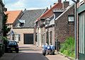 Street view
 -
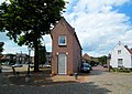
 House in Stevensweert
 -
 Square
 -
 House in Stevensweert


References
- ^ a b c "Kerncijfers wijken en buurten 2021". Central Bureau of Statistics. Retrieved 25 April 2022.
- ^ "Postcodetool for 6107AA". Actueel Hoogtebestand Nederland (in Dutch). Het Waterschapshuis. Retrieved 25 April 2022.
- ^ "Kessenich". Agentschap Onroerend Erfgoed (in Dutch). Retrieved 25 April 2022.
- ^ a b "Stevensweert - (geografische naam)". Etymologiebank (in Dutch). Retrieved 25 April 2022.
- ^ ISBN 90 400 9623 6. Retrieved 25 April 2022.
- ^ a b "Hompesche Molen". Molen database (in Dutch). Retrieved 25 April 2022.
- ^ a b "Stevensweert". Plaatsengids (in Dutch). Retrieved 25 April 2022.
| Authority control databases: National |
|---|