
Stratocumulus cloud
This article needs additional citations for verification. (September 2008) |
| Stratocumulus clouds | |
|---|---|
 Aerial photograph of Stratocumulus perlucidus clouds over the midwestern United States | |
| Abbreviation | Sc |
| Symbol | |
| Genus | Stratocumulus (layer heap) |
| Species |
|
| Variety |
|
| Altitude | 500-2,000 m (2,000-7,000 ft) |
Snow pellets | |
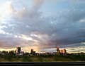
A stratocumulus cloud, occasionally called a cumulostratus, belongs to a genus-type of clouds characterized by large dark, rounded masses, usually in groups, lines, or waves, the individual elements being larger than those in altocumulus, and the whole being at a lower height, usually below 2,000 metres (6,600 ft).[1][2] Weak convective currents create shallow cloud layers (see also: sea of clouds) because of drier, stable air above preventing continued vertical development. Historically, in English, this type of cloud has been referred to as a twain cloud for being a combination of two types of clouds.
Description
Stratocumulus clouds are rounded clumps or patches of white to dark gray clouds that normally form in groups. The individual cloud elements, which cover more than 5 degrees of arc each, can connect with each other and are sometimes arranged in a regular pattern.[3][4][5]
Occurrence
Vast areas of subtropical and
Precipitation
Most often, stratocumulus produce no precipitation, and when they do, it is generally only light

Comparison with altocumulus
Stratocumulus clouds are similar in appearance to altocumulus and can be mistaken for such. A simple test to distinguish these is to compare the size of individual masses or rolls: when pointing one's hand in the direction of the cloud, if the cloud is about the size of the thumb, it is altocumulus; if it is the size of one's fist, it is stratocumulus.[3] This often does not apply when stratocumulus is of a broken, fractus form, when it may appear as small as altocumulus.
Optical effects
Stratocumulus clouds are the main type of cloud that can produce crepuscular rays. Thin stratocumulus clouds are also often the cause of corona effects around the Moon at night. All stratocumulus subtypes are coded CL5 except when formed from free convective mother clouds (CL4) or when formed separately from co-existing (CL8).
Formation
Stratocumulus clouds usually form from the rising and breakup of a
Species
Stratocumulus Stratiformis are extensive flat but slightly lumpy sheets that show only minimal convective activity.
Stratocumulus Lenticularis are separate flat elongated seed-shaped clouds. They are typical for polar countries or warmer climate during winter seasons. They also can be formed by winds passing hills or mountains, such as Foehn winds, and in this case they can be very regularly shaped.
Stratocumulus Castellanus have stronger convective activity due to the presence of increasingly unstable air. They are distinct from other stratocumulus by puffy tower-like formations atop the cloud layer.
-
 Stratocumulus stratiformis
 -
 Stratocumulus lenticularis
 -
 Stratocumulus castellanus


Opacity-based varieties
Stratocumulus Opacus is a dark layer of clouds covering entire sky without any break. However, the cloud sheet is not completely uniform, so that separate cloud bases still can be seen. This is the main precipitating type, however any rain is usually light. If the cloud layer becomes grayer to the point when individual clouds cannot be distinguished, stratocumulus turn into stratus clouds.
Stratocumulus Perlucidus is a layer of stratocumulus clouds with small spaces, appearing in irregular pattern, through which clear sky or higher clouds can be seen.
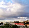
Stratocumulus Translucidus consist of separate groups of stratocumulus clouds, with a clear sky (or higher clouds) visible between them. No precipitation in most cases.[8]
Pattern-based varieties
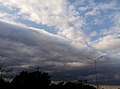
Stratocumulus Undulatus clouds appear as nearly parallel waves, rolls or separate elongated clouds, without significant vertical development.[8]
Stratocumulus Radiatus clouds appear as the same as stratocumulus undulatus, but stratocumulus undulatus move perpendicular to the wind shear, while stratocumulus radiatus move parallel to the wind shear.
Stratocumulus Duplicatus clouds appear as stratocumulus clouds with two or more layers or sheets. Stratocumulus duplicatus is common on species lenticularis or lenticular cloud.
Stratocumulus Lacunosus clouds are very uncommon. They only occur when there are localized
-
 Stratocumulus undulatus clouds, seen from an airplane
 -
 Stratocumulus undulatus asperitas clouds, seen from Earth
 -
 Stratocumulus radiatus
 -
 Stratocumulus duplicatus; Stratocumulus stratiformis (right) and Stratocumulus floccus (left)
 -
 Stratocumulus lacunosus


Supplementary feature
Stratocumulus Mamma is a type of mammatus cloud.[9]

Stratocumulus Asperitas is a rare, newly recognized supplementary feature that presents itself as chaotic, wavy undulations appearing in the base of a stratocumulus cloud cover. It is thought these clouds are formed by severe wind shear.
Stratocumulus Fluctus is also a rare, newly recognized supplementary feature in which short-lived "sea waves" form on top of a stratocumulus cloud, they are caused by wind speed and direction differences directly under and over the cloud.
Precipitation-based supplementary features
Stratocumulus Virga is a form of precipitation that evaporates in mid-air and doesn't reach the ground.
Stratocumulus Praecipitatio is a form of precipitation that reaches the ground as light rain or snow.
-
 Stratocumulus stratiformis opacus radiatus praecipitatio

Mother clouds
Stratocumulus Cumulomutatus the specific type of stratocumulus clouds, are flat and elongated. They form in the evening, when updrafts caused by convection decrease making
Stratocumulus Cumulogenitus out of
Hypothetical break-up
In 2019, a study employed a
See also
Sources
- References
- ISBN 92-63-10407-7. Retrieved 28 November 2014.
- ^ "International cloud atlas–Definitions of clouds". World Meteorological Organization. Retrieved 25 September 2018.
- ^ a b c "Stratocumulus clouds". Meteorological Office of the UK. Retrieved 10 November 2023.
- ^ Cohn et al. 2017, Section 2.3.7
- ^ "Ten Basic Clouds". JetStream. National Oceanic and Atmospheric Administration. Retrieved 10 November 2023.
- ^ a b Cohn et al. 2017, Section 2.3.7.5
- ISBN 92-63-10407-7. Retrieved 26 August 2014.
- ^ a b World Meteorological Organization, ed. (1975). Varieties, International Cloud Atlas (PDF). pp. 20–22. Retrieved 26 August 2014.
- ISBN 92-63-10407-7. Retrieved 26 August 2014.
- S2CID 134307699.
- ^ Wolchover, Natalie (25 February 2019). "A World Without Clouds". Quanta Magazine. Retrieved 2 October 2022.
- PMID 33199624.
- ^ a b "Extreme CO2 levels could trigger clouds 'tipping point' and 8C of global warming". Carbon Brief. 25 February 2019. Retrieved 2 October 2022.
- ^ Voosen, Paul (February 26, 2019). "A world without clouds? Hardly clear, climate scientists say". Science Magazine.
- Bibliography
- Cohn, Stephen; Bruhn, Michael; Anderson, George; Atkinson, Roger; Campos, Marinés; Galati, Federico; Lovell, Ernest; Rae, Colleen; Rüedi, Isabelle; Tam, Kwong Hung; Thürig-Jenzer, Eliane; Trice, Jim (2017). International Cloud Atlas. World Meteorological Organization. Retrieved 25 March 2022.
- Cesana, Grégory; Del Genio, Anthony; Chepfer, Hélène. "The Cumulus And Stratocumulus CloudSat-CALIPSO Dataset (CASCCAD)" (PDF). Retrieved 10 November 2023.
External links
- Clouds-Online.com Cloud Atlas with many photos and description of the different cloud genus
- National Science Digital Library – Stratocumulus
- Muriel Martin Online – Stratocumulus Cloud
- WW2010 University of Illinois – Stratocumulus Clouds
- BBC Weather Centre – Types of Cloud – Stratocumulus and Altocumulus