
Arcus cloud

| Part of a series on |
| Weather |
|---|
|
|
An arcus cloud is a low, horizontal
Types
Shelf cloud
A shelf cloud is a low, horizontal, wedge-shaped arcus cloud attached to the base of the parent
People seeing a shelf cloud may believe they have seen a wall cloud. This is likely to be a mistake, since an approaching shelf cloud appears to form a wall made of cloud. Shelf clouds usually appear on the leading edge of a storm, while wall clouds are usually at the rear of the storm.
A sharp, strong gust front will cause the lowest part of the leading edge of a shelf cloud to be ragged and lined with rising fractus clouds. In a severe case there will be vortices along the edge, with twisting masses of scud that may reach to the ground or be accompanied by rising dust. A very low shelf cloud accompanied by these signs is the best indicator that a potentially violent wind squall is approaching. An extreme example of this phenomenon looks almost like a tornado and is known as a gustnado.[1]
-
 Underside of a weak shelf cloud.
 -

-
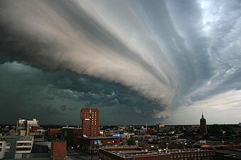 A shelf cloud over Enschede, Netherlands
 -
 A shelf cloud in Durango, Mexico


Roll cloud
A roll cloud (Cloud Atlas name volutus) is a low, horizontal, tube-shaped, and relatively rare type of arcus cloud. They differ from shelf clouds by being completely detached from other cloud features. Roll clouds usually appear to be "rolling" about a horizontal axis. They are a solitary wave called a soliton, which is a wave that has a single crest and moves without changing speed or shape. This rolling is due to the variation in speed and direction of the winds with altitude (wind shear).[2]
One of the most famous frequent occurrences is the
However, similar features can be created by
Roll clouds have not been associated with funnel clouds or tornadoes as they are a horizontal vortex.[2]
-
 A roll cloud associated with a severe thunderstorm over Racine, Wisconsin, United States
 -
![Coastal roll cloud in Punta del Este, Maldonado, Uruguay, a type known as Volutus[5]](//upload.wikimedia.org/wikipedia/commons/thumb/0/08/Roll-cloud.JPG/300px-Roll-cloud.JPG)
-
 A sequence of volutus clouds at sea in the Drake Passage of the Southern Ocean
 -
 Roll clouds over southern Brazil.

![Coastal roll cloud in Punta del Este, Maldonado, Uruguay, a type known as Volutus[5]](/File:Roll-cloud.JPG)


See also
- Atmospheric convection
- Horizontal convective rolls (cloud streets)
- International Cloud Atlas
- Morning Glory cloud, an extremely long variety of roll cloud
- World Meteorological Organization
References
- Environment Canada. Archived from the originalon June 23, 2006. Retrieved 2008-06-22.
- ^ NASA. Retrieved June 1, 2014..
- .
- ^ "Roll clouds slide over Wichita". ktvb.com. 28 April 2020. Retrieved 2023-07-24.
- ^ Sutherland, Scott (March 23, 2017). "Cloud Atlas leaps into 21st century with 12 new cloud types". The Weather Network. Pelmorex Media. Retrieved 24 March 2017.
External links
- Environment Canada. Archived from the originalon July 15, 2013. Retrieved 2010-10-07.
- Roll Cloud vs. Shelf Cloud
- "Stunning shelf cloud captured in Dorset before storm hit". BBC News. 6 September 2022. Retrieved 10 September 2022.