
Suðuroy
This article has multiple issues. Please help improve it or discuss these issues on the talk page. (Learn how and when to remove these template messages)
|
Suðuroy
Suderø ( EST) | |
|---|---|
| Calling code | 298 |
Suðuroy (pronounced [ˈsʊɹɔɪ] literally ‘South Island’, Danish: Suderø) is the southernmost of the Faroe Islands. The island covers 163.7 square kilometres (63.2 sq mi). In 2018 the population was 4,601. Suðuroy region (sýsla) comprises this island and Lítla Dímun
History
One ancient settlement,
In the 17th century, Suðuroy was subjected to repeated attacks by North African pirates, who in the Faroe Islands were referred to as Turks when North Africa belonged to the Ottoman Empire. One well known such incident was the Slave raid of Suðuroy .They abducted several women and children.[2] Famine ensued, and many of the island's inhabitants died of starvation. In 1615, the pirate-plagued Hvalba was rescued by two Danish warships in the spring. The pirates, who used Hvalba as a kind of base port, had unfortunately sailed 14 days before the arrival of the Danish squadron.
The village of Sandvík was re-established in the 19th century. Fámara was re-settled in 2010 with the expansion of Vágur beyond its original town borders. Two more settlements were started in the early and mid-20th century: Botni, northwest of Vágur, and Tjaldavík, in a bay southeast of Øravík. Both sites have been abandoned again.
Suðuroy's population has been falling gradually since the 1970s. In 1985, the island had 5,881 inhabitants, but by 2019 the population fell to a record low of 4,591.[3]
Geography
The highest point of Suðuroy is the mountain Gluggarnir (610 metres or 2,001 feet),[4] but the most famous peak is definitely the mountain of Beinisvørð northwest of the village of Sumba. The Beinisvørð and its scenery have been praised by the local poet Poul F. Joensen (1898–1970), as well as other Faroese poets. Suðuroy is the island which has the most islets and skerries. Suðuroy and the islets and skerries near the island number 263, including the island itself.[5]
The inhabited settlements on Suðuroy include, from north to south: Sandvík, Hvalba, Froðba, Tvøroyri, Trongisvágur, Øravík, Fámjin, Hov, Porkeri, Nes, Vágur, Fámara, Akrar, Lopra and Sumba.
Suðuroy is also the only island of the Faroes which has coalmines, one of which is still active. It is located in Hvalba, near the tunnel. Other coalmines were in Rangabotnur in Trongisvágur (on the south side of Trongisvágsfjørður), and in Fámjin. The bays of Øravík, Trongisvágur, Fámjin, Vágur and Hvalba are designated grind bays.[6]
In contrast to the name Suðuroy (South Island, singular), the name Suðuroyggjar (Southern Islands, plural) refers to the Outer Hebrides in Scotland. To refer to the islands south of Skopunarfjørður one can colloquially say (going) "sunnanfjørðs" or formally Suðurøkið.
Important Bird Area
The western side of the island has been identified as an
Transport and infrastructure
MS Smyril operates two to three times daily between Tórshavn and Suðuroy, leaving from the new ferry port of Krambatangi on the south side of the fjord of Trongisvágsfjørður. The journey takes two hours. There are two national bus routes in Suðuroy, route 700 operates between Tvøroyri and Sumba (the southern line) and 701 between Fámjin and Sandvík (the northern line). There is a heliport at Froðba with flights to Tórshavn and Vágar Airport.
A road network runs the entire length of the island, including five road tunnels: the Sandvíkartunnilin (1969), the old and new Hvalbiartunnilin (1965 and 2021), Hovstunnilin (2007) and Sumbiartunnilin (1997). The Fámjinstunnilin will be started with in 2022. The proposed Suðuroyartunnilin would connect the island with Skúvoy and Sandoy, replacing the ferry Smyril.
The Suðuroy
Sights and activities
This section is written like a encyclopedic style or move the content to Wikivoyage . (January 2022) |
Cliffs

Vágseiði is a place with 200-metre-high (660 ft) cliffs towards south, but the road is down by the sea, the skerries are called Heltnarnar and a cliff on Vágseiði is called Múlatangi.
Eggjarvegur on the south side of the fjord, Vágsfjørður, leads up to Eggjarnar, 200 m (660 ft) on a vertical cliff with a view towards Beinisvørð in the south and to Vágseiði in the north. On Eggjarnar, visitors can find two concrete bunkers which were British observation points during World War II. There is also an abandoned former Loran-C radar station, as it closed down in the mid-1970s.
South of Eggjarnar is the isthmus of
Fámjin

Hikes
Tvøroyri there is an attractive walk across the mountains to a valley called Hvannhagi. There is a view over the valley and to Lítla Dímun and Stóra Dímun and the sea from above the valley. No roads lead to this valley.
Jóansøka
. It runs in late June, in the last weekend of June, the rowing competition is always on Saturday of the Jóansøka weekend.Theatres
In Øravíkarlíð near the ferry terminal the island's main cultural venue SALT sits in a former salt silo. It was abandoned in 1980 and after repurposing opened as a theatre in 2017.[15][16]
Sports in Suðuroy

Football in Suðuroy
The oldest sports club in the
Swimming in Suðuroy
Suðuroy has recently had good results in international swimming competitions. The two swimming clubs in Suðuroy "Vágs Svimjifelag" and "Tvøroyrar Svimjifelag" joined forces 6 September 2007 and founded Susvim, which is for the whole island. A young man from Vágur has had the best results until now. Pál Joensen won triple gold in the 2008 European Junior Swimming Championships on the short course in the men's 400 M, 800 M and 1500 M Freestyle. Two years later he won silver in the Men's 1500 M Freestyle at the 2010 European Aquatics Championships.[17] Other swimmers from Susvim have also had good results in Faroe Islands and in Denmark and other countries and at the Island Games competitions.
Rowing in Suðuroy
There are two active rowing clubs in Suðuroy, Vágs Kappróðrarfelag from Vágur and Froðbiar Sóknar Róðrarfelag from Tvøroyri and the villages around Trongisvágsfjørður (fjord). There are also rowing clubs in Sumba and in Hvalba. In Sumba they had a boat which was called Broddur, but they have not been active for some years now. In Hvalba they had a boat which was named Snopprikkur after a well-known man from the history of Suðuroy (Suðuroyar Sagnir). Vágs Kappróðrarfelag has these boats: Royndin Fríða, which is a so-called 5-mannafar, Smyril, which is a 6-mannafar, and Toftaregin, which is an 8-mannafar and Vágbingur, which is a 10-mannafar. Froðbiar Sóknar Róðrarfelag has the boats Firvaldur, which is a 5-mannafar (Firvaldur means Butterfly), Firildur and Hulda are also 5-mannafar, Tvørábáturin is a 6-mannafar, Suðringur and another Tvørábáturin are 10-mannafar (there are two boats which are called Tvørábáturin, which means the boat from Tvøroyri).[18]
Gallery
-
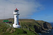 Lighthouse Akraberg build 1909.
 -
 View towards south from the headland of Akraberg, which is the southernmost tip of Suðuroy.
 -

-
 The westcoast between Beinisvørð and Vágur
 -

-
 Hov with Borgaknappur in the background.
 -

-
 Tvøroyri seen from M/F Smyril.
 -

-
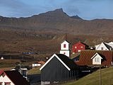
 Hvalba and Lítla Dímun
 -
 Glyvrabergsgjógv, west of Sandvík
 -
 Ásmundarstakkur west of Sandvík
 -
 M/F Smyril, the ferry between Suðuroy and Tórshavn.
 -
 Hvannhagi
 -
 View towards north from Beinisvørð, Suðuroy.


References
- ^ Statistical Database
- ^ Joensen 1981, pp. 211–245.
- ^ "Changes in population by born, dead, migrated, village and month (1985-2020)".
- ^ us.fo Archived 2015-07-15 at the Wayback Machine
- ^ US.fo Archived 2013-10-21 at the Wayback Machine
- ^ Heimabeiti. "Hvalvágir góðkendar". Heimabeiti (in Faroese). Retrieved 2020-08-20.
- ^ BirdLife International. (2012). Important Bird Areas factsheet: Suduroy. Downloaded from http://www.birdlife.org on 2012-02-24.
- ^ "Vágsverkið". www.sev.fo (in Faroese). Archived from the original on 14 February 2021.
- ^ Mikladal, Poul A. (December 2005). "Sustainable energy in the Faroe Islands - the role of hydropower" (PDF). Faroese Prime Minister's Office. p. 15. Retrieved 1 March 2017.
- ^ "Sólorka". www.sev.fo (in Faroese). Archived from the original on 9 February 2021.
- ^ a b "40% green energy in the first half-year of 2021". www.sev.fo (in Faroese). 15 July 2021.
- ^ "SEV recommends wind turbines for Suðuroy". SEV. 2014-10-02. Archived from the original on 2 March 2017. Retrieved 1 March 2017.
- ^ "Hitachi Energy 7.5MWh BESS project to help Faroe Islands towards 100% renewables by 2030". Energy Storage News. 16 December 2021.
- ^ "Vindmyllulund í Porkerishaganum". www.sev.fo (in Faroese).
- ^ "History of SALT".
- ^ Fólk á ferð: Strandferðslan 100 ár. Tvøroyri: Strandfaraskip Landsins. 2017.
- ^ Swimmingworldmagazine.com Archived 2012-08-19 at the Wayback Machine
- ^ Drekin.fo Archived 2011-07-20 at the Wayback Machine
Sources
- Hagstova.fo, Faroe Islands Statistics
- Susvim
Bibliography
- Joensen, H.D. (1981). Sambandið føroyinga og útlendinga millum. Hugleiðingar um viðurskiftini frá 1273 til 1856 [The relationship between Faroese and foreigners. Reflections on the trade from 1273 to 1856] (in Faroese). Fróðskaparrit.
External links
- Visitsuduroy.fo, General travel information about Suðuroy
- Sudurras.com, Suðurrás The News Portal of Suðuroy
- SSL.fo, Time schedule of Smyril the Suðuroy ferry and busses
- Smyril - The ferry to Suðuroy
- Painting Courses in Suðuroy
- Art Gallery Oyggin
- Ruth Smith Art Museum
- Photos on Flickr tagged with Suðuroy.
Islands of the Faroe Islands | ||
|---|---|---|
Faroe Islands articles | |||||||
|---|---|---|---|---|---|---|---|
| |||||||
| History |  | ||||||
| Geography |
| ||||||
| Politics |
| ||||||
| Economy | |||||||
| Society |
| ||||||
| |||||
| Overseas autonomous countries | |||||
| International | |
|---|---|
| National | |