
Sugarloaf Mountain (Massachusetts)
| Sugarloaf Mountain (South Sugarloaf and North Sugarloaf) | |
|---|---|
Fault-block; sedimentary | |
| Climbing | |
| Easiest route | Auto road |
Sugarloaf Mountain or Mount Sugarloaf, is a butte-like mountain located in South Deerfield, Massachusetts, United States, with two summits, North Sugarloaf Mountain 791 ft (241 m) and its more popular knee, South Sugarloaf Mountain 652 ft (199 m). Its cliffs, made of arkose sandstone, are a very prominent landscape feature visible for miles. Despite low elevations relative to the Berkshire Mountains to the west, dramatic cliff faces and a rise of 500 feet (150 m) to 600 feet (180 m) from the nearby Connecticut River make the mountain a popular tourist and hiking destination. Sugarloaf Mountain is the southern terminus of the Pocumtuck Range.
Origin of the name

The name
The original
Geology
Sugarloaf Mountain, geologically contiguous with the Pocumtuck Ridge to the north, is composed of
About 200 million years ago, as the continent of
The Sugarloaf Formation (or Sugarloaf Arkose), of which Mt. Sugarloaf is partially composed, was deposited mainly by rivers and alluvial fans, with some localized floodplain ponds or swamps.[8][9] The formation is known in other locations to preserve Triassic fossils such coprolites, plant remains such as Clathropteris and Equisitites , and fishes such as Semionotus, Redfieldius, and Ptycholepis.[9] Additionally, the Sugarloaf Formation preserves rare examples of lithified armored mud balls.[10]
Recreation

A seasonal auto road climbs the summit of South Sugarloaf (open late spring through the
Most of the mountain has been conserved as part of the Mount Sugarloaf State Reservation. The reservation is easily accessible via Route 116 and is only a 15-minute drive from the University of Massachusetts Amherst campus. There is parking at the base of the mountain and at the top of the paved road that leads from the parking area to the summit of South Sugarloaf. It is free to hike the trails or climb the road by foot or by bike, but there is a nominal fee for vehicles.[12] North Sugarloaf Mountain is only accessible by foot; a small cave is located just beneath the summit ledges.
Film and television
In Fall 2008, the Mel Gibson film Edge of Darkness was filmed at the summit of South Sugarloaf. The observation tower was temporarily renovated for the film.[13]
Gallery
-
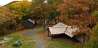
 Observation Deck on Mt Sugarloaf in South Deerfield MA.
 -
 Picnic Grove on Mt Sugarloaf, South Deerfield MA
 -
 View of the Connecticut River and the Pioneer Valley looking East South East from Mt Sugarloaf in South Deerfield MA.
 -
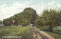 South Sugarloaf. 1910 postcard.


See also
- Mount Sugarloaf and Sugarloaf Mountain are also the names of numerous other hills and mountains worldwide. Several nearby mountains with the name "Sugarloaf" are located in Maine, Vermont, New Hampshire, and Connecticut.
References
- ^ Massachusetts Trail Guide 8th ed. Appalachian Mountain Club. Boston, 2004.
- ^ a b Connecticut River Home Page Archived 2007-12-09 at the Wayback Machine. Cited Dec. 17, 2007
- ^ a b AMC Massachusetts and Rhode Island Trail Guide. 6th ed. Appalachian Mountain Club, Boston, Massachusetts, 1989.
- ^ Christopher J. Ryan. "Mount Toby Trail Map". Fourth edition. Newall Printing, Amherst, Massachusetts, 1999.
- ^ [1] United States Board on Geographic Names. Cinted Dec. 5, 2007
- ^ "Stratigraphy and Paleocology of the Deerfield Rift Basin (Triassic-Jurassic, Newark Supergroup), Massachusetts". Guidebook for Field Trips in the Connecticut Valley Region of Massachusetts and Adjacent States. vol. 2, 84th annual meeting, New England Intergollegiate Geological Conference, The Five Colleges. Amherst, Massachusetts. October 9–10-11, 1992: 488-535. Cited from the web, Dec. 1, 2007.
- Raymo, Maureen E.Written in Stone: A Geologic History of the Northeastern United States. Globe Pequot, Chester, Connecticut, 1989.
- ^ Walsh, Matthew (2008-01-01). "Petrology and Provenance of the Triassic Sugarloaf Arkose, Deerfield Basin, Massachusetts". Masters Theses 1911 - February 2014.
- ^ a b Mcdonald, Nicholas; Ed, Joesten Raymond; Ed, Quarrier Sidney S. (1982). "PALEONTOLOGY OF THE MESOZOIC ROCKS OF THE CONNECTICUT VALLEY".
{{cite journal}}: Cite journal requires|journal=(help) - ^ Little, R. D. (2020). Exploring Franklin County, Western Massachusetts: Your Guide to Amazing Stories in Rocks & Landscapes. Easthampton, MA: Earth View LLC.
- ^ [2] South Sugarloaf Mountain - FranklinSites.com Hiking Guide
- ^ http://www.mass.gov/eea/agencies/dcr/massparks/region-west/mount-sugarloaf-state-reservation.html Massachusetts DCR. Cited Dec. 5, 2007
- ^ "News and Information from Greenfield, MA | the Recorder". Archived from the original on 2013-07-25. Retrieved 2008-09-19.
External links
- Map of Mount Toby
- The view from atop Mount Sugarloaf in Deerfield is shown Aug. 11, 2017 by Chris Goudreau, Valley Advocate, Feb. 13, 2018