
Connecticut River
| Connecticut River | |
|---|---|
Coos County, New Hampshire, United States | |
| • coordinates | 45°14′53″N 71°12′51″W / 45.24806°N 71.21417°W |
| • elevation | 2,660 ft (810 m) |
| Mouth | Long Island Sound |
• location | Old Saybrook and Old Lyme, Connecticut[2] |
• coordinates | 41°16′20″N 72°20′03″W / 41.27222°N 72.33417°W |
| Length | 410 mi (660 km) |
| Basin size | 11,260 sq mi (29,200 km2) |
| Discharge | |
| • location | Thompsonville, Connecticut |
| • average | 18,400 cu ft/s (520 m3/s) |
| • minimum | 968 cu ft/s (27.4 m3/s) |
| • maximum | 282,000 cu ft/s (8,000 m3/s) |
| Discharge | |
| • location | West Lebanon, New Hampshire |
| • average | 6,600 cu ft/s (190 m3/s) |
| Basin features | |
| Tributaries | |
| • left | Chicopee River |
| • right | White River |
| Protection status | |
| Official name | Connecticut River Estuary and Tidal River Wetlands Complex |
| Designated | October 14, 1994 |
| Reference no. | 710[3] |
The Connecticut River is the longest river in the New England region of the United States, flowing roughly southward for 406 miles (653 km) through four states. It rises 300 yards (270 m) south of the U.S. border with Quebec, Canada, and discharges at Long Island Sound.[4] Its watershed encompasses 11,260 square miles (29,200 km2), covering parts of five U.S. states and one Canadian province, via 148 tributaries, 38 of which are major rivers.[5] It produces 70% of Long Island Sound's fresh water,[5] discharging at 18,400 cubic feet (520 m3) per second.[6]
The Connecticut River Valley is home to some of the northeastern United States' most productive farmland, as well as the Hartford–Springfield Knowledge Corridor, a metropolitan region of approximately two million people surrounding Springfield, Massachusetts, and Hartford, Connecticut.[7]
History
The word "Connecticut" is a corruption of the Mohegan word quinetucket and Nipmuc word kwinitekw, which mean "beside the long, tidal river".[8][9] The word came into English during the early 1600s to name the river, which was also called simply "The Great River". It was also known as the Fresh River, and the Dutch called it the Verse River.[10]
Early spellings of the name by European explorers included "Cannitticutt" in French[11] or in English.[12]


Pre-1614: American Indian populations
Archaeological digs reveal human habitation of the Connecticut River Valley for 6,000 years before present.[13] Numerous tribes lived throughout the fertile Connecticut River valley prior to Dutch exploration beginning in 1614. Information concerning how these tribes lived and interacted stems mostly from English accounts written during the 1630s.[14]
The
The Mattabesset (Tunxis) tribe takes its name from the place where its sachems ruled at the Connecticut River's Big Bend at Middletown, in a village sandwiched between the territories of the aggressive Pequots to the south and the more peaceable Mohegans to the north.[16]
The Mohegans dominated the region due north, where Hartford and its suburbs sit, particularly after allying themselves with the Colonists against the Pequots during the Pequot War of 1637.[17] Their culture was similar to the Pequots, as they had split off from them and become their rivals some time prior to European exploration of the area.[17]
The agricultural
The
1614–1636: Dutch and Puritan settlement
In 1614, Dutch explorer Adriaen Block became the first European to chart the Connecticut River, sailing as far north as Enfield Rapids.[28] He called it the "Fresh River" and claimed it for the Netherlands as the northeastern border of the New Netherland colony. In 1623, Dutch traders constructed a fortified trading post at the site of Hartford, Connecticut, called the Fort Huys de Hoop ("Fort House of Hope").[29]
Four separate Puritan-led groups also settled the fertile Connecticut River Valley, and they founded the two large cities that continue to dominate the Valley: Hartford (est. 1635) and Springfield (est. 1636). The first group of pioneers left the Plymouth Colony in 1632 and ultimately founded the village of Matianuck (which became Windsor, Connecticut) several miles north of the Dutch fort. A group left the Massachusetts Bay Colony from Watertown, seeking a site where they could practice their religion more freely. With this in mind, they founded Wethersfield, Connecticut, in 1633, several miles south of the Dutch fort at Hartford.
.jpg)
In 1635, Reverend Thomas Hooker led settlers from Cambridge, Massachusetts, where he had feuded with Reverend John Cotton, to the site in Connecticut of the Dutch Fort House of Hope, where he founded Newtowne.[29] Shortly after Hooker's arrival, Newtowne annexed Matianuck based on laws articulated in Connecticut's settlement charter, the Warwick Patent of 1631. The patent, however, had been physically lost, and the annexation was almost certainly illegal.[30]
The fourth English settlement along the Connecticut River came out of a 1635 scouting party commissioned by William Pynchon to find the most advantageous site for commerce and agriculture, hoping to found a city there. His scouts located the Pocumtuc village of Agawam, where the Bay Path trade route crossed the Connecticut River at two of its major tributaries—the Chicopee River to the east and Westfield River to the west—and just north of Enfield Falls, the river's first unnavigable waterfall. Pynchon surmised that traders using any of these routes would have to dock and change ships at his site, thereby granting the settlement a commercial advantage.[31] It was initially named Agawam Plantation and was allied with the settlements to the south that became the state of Connecticut, but it switched allegiances in 1641 and was renamed Springfield in honor of Pynchon's native town in England.[31]
Of these settlements, Hartford and Springfield quickly emerged as powers. In 1641, Springfield splintered off from the Hartford-based Connecticut Colony, allying itself with the Massachusetts Bay Colony. For decades, Springfield remained the Massachusetts Bay Colony's westernmost settlement, on the northern border of the Connecticut Colony. By 1654, however, the success of these English settlements rendered the Dutch position untenable on the Connecticut River. A treaty moved the boundary westward between the Connecticut Colony and New Netherland Colony to a point near Greenwich, Connecticut. The treaty allowed the Dutch to maintain their trading post at Fort Huys de Hoop, which they did until the 1664 British takeover of New Netherland.
Border disputes
The Connecticut River Valley's central location, fertile soil, and abundant natural resources made it the target of centuries of border disputes, beginning with Springfield's defection from the Connecticut Colony in 1641, which brought the Massachusetts Bay Colony to the river. In 1640, Massachusetts Bay Colony asserted a claim to jurisdiction over lands surrounding the river; however, Springfield remained politically independent until tensions with the Connecticut Colony were exacerbated by a final confrontation later that year.[31]

Hartford kept a fort at the mouth of the Connecticut River at
The Fort at Number 4 in Charlestown, New Hampshire, was the northernmost British colonial presence on the Connecticut River until the end of the French and Indian War in 1763. The Abenaki had resisted British colonial settlement for decades, but colonists began settling north of Brattleboro, Vermont, following the war.[32] Settlement of the Upper Connecticut River Valley increased quickly, with population assessments of 36,000 by 1790.[32]
Vermont was claimed by both New Hampshire and
The Treaty of Paris and the 19th century

The
The broad, fertile Connecticut River Valley attracted agricultural settlers and colonial traders to Hartford, Springfield, and the surrounding region. The high volume and numerous falls of the river led to the rise of industry along its banks during the Industrial Revolution. The cities of Springfield and Hartford in particular became centers of innovation and "intense and concentrated prosperity."[38]
The Enfield Falls Canal was opened in 1829 to circumvent shallows around Enfield Falls, and the locks built for this canal gave their name to the town of Windsor Locks, Connecticut.[39] The Connecticut River Valley functioned as America's hub of technical innovation into the 20th century, particularly the cities of Springfield and Hartford, and thus attracted numerous railroad lines. The proliferation of the railroads in Springfield and Hartford greatly decreased the economic importance of the Connecticut River. From the late 1800s until today, it has functioned largely as a center of wildlife and recreation.[40]
Log drives and the early 20th century

Starting about 1865,
The flood of 1936
In March 1936, due to a winter with heavy snowfall, an early spring thaw and torrential rains, the Connecticut River flooded, overflowing its banks, destroying numerous bridges and isolating hundreds of people who had to be rescued by boat.
The dam at Vernon, Vermont, was topped by 19 feet (5.8 m). Sandbagging by the National Guard and local volunteers helped prevent the dam's powerhouse from being overwhelmed, despite blocks of ice breaking through the upstream walls.[46]
In
Unprecedented accumulated ice jams compounded the problems created by the flood, diverting water into unusual channels and damming the river, raising water levels even further. When the jam at

In Springfield, Massachusetts, 5 sq mi (13 km2), and 18 miles (29 km) of streets, were flooded, and 20,000 people lost their homes. The city lost power, and nighttime looting caused the police to issue a "shoot on sight" edict; 800 National Guard troops were brought in to help maintain order. Rescue efforts using a flotilla of boats saved people trapped in upper stories of buildings, bringing them to local fraternal lodges, schools, churches and monasteries for lodging, medical care, and food. The American Red Cross and local, state and federal agencies, including the WPA and the CCC, contributed aid and manpower to the effort. Flooding of roads isolated the city for a time. When the water receded, it left behind silt-caused mud which in places was 3 feet (1 m) thick; the recovery effort in Springfield, at the height of the American Great Depression, took approximately a decade.
Overall, the flood caused 171 deaths and US$500 million (US$11,000,000,000 with inflation[47]) in damages. Across the northeast, over 430,000 people were made homeless or destitute by flooding that year.[48]
The Connecticut River Flood Control Compact between the states of Connecticut, Massachusetts, New Hampshire, and Vermont was established in 1953 to help prevent serious flooding.[49]
1936–present: Water supply
The creation of the
Demand for drinking water in eastern Massachusetts passed the sustainable supply from the existing system in 1969. Diverting water from the Connecticut River was considered several times,[51] but in 1986 the Massachusetts Water Resources Authority instead undertook a campaign of water conservation. Demand was reduced to sustainable levels by 1989, reaching approximately a 25% margin of safety by 2009.[52]
Course
The Connecticut River is the largest river ecosystem in New England. Its watershed spans Connecticut, Massachusetts, New Hampshire, Vermont, small portions of Maine, and the Canadian province of Quebec.[5][37][53]
The Upper Connecticut River: New Hampshire and Vermont

_at_high_flow_2-26-2016.JPG)
The Connecticut River rises from
The region along the river upstream and downstream from Lebanon, New Hampshire, and White River Junction, Vermont, is known as the "Upper Valley". The exact definition of the region varies, but it generally is considered to extend south to Windsor, Vermont, and Cornish, New Hampshire, and north to Bradford, Vermont, and Piermont, New Hampshire.[55] In 2001, the Trust for Public Land purchased 171,000 acres (690 km2) of land in New Hampshire from International Paper, allowing the Connecticut Lakes Headwaters Partnership Task Force to plan the future protection of the land.[56] The property spans the towns of Pittsburg, Clarksville, and Stewartstown, New Hampshire, nearly 3 percent of the land in the state of New Hampshire.[57] The Trust for Public Land worked in partnership with the Society for the Protection of New Hampshire Forests, The Nature Conservancy of New Hampshire, and others to raise around $42 million.[56] A conservation easement over 146,000 acres (590 km2) of the property prohibits development of the land while allowing public access.[57] The forest is managed by the Lyme Timber Company, and the conservation easement over the land ensures sustainable forest management of the property.[57]
The Middle Connecticut River: Massachusetts through central Connecticut
Following the most recent ice age, the Middle Connecticut River Valley sat at the bottom of Lake Hitchcock. Its lush greenery and rich, almost rockless soil comes from the ancient lake's sedimentary deposits.[58] In the Middle Connecticut region, the river reaches its maximum depth – 130 feet (40 m) – at Gill, Massachusetts, around the French King Bridge, and its maximum width – 2,100 feet (640 m) – at Longmeadow, directly across from the Six Flags New England amusement park.[37][59] The Connecticut's largest falls – South Hadley Falls – features a vertical drop of 58 feet (18 m).[5] Lush green forests and agricultural hamlets dot this middle portion of the Connecticut River; however, the region is best known for its numerous college towns, such as Northampton, South Hadley, and Amherst, as well as the river's most populous city, Springfield. The city sits atop bluffs beside the Connecticut's confluence with two major tributaries, the Chicopee River to the east and Westfield River to the west.[60] The region around the Connecticut River is known locally as the Pioneer Valley, and the name adorns many local civic organizations and local businesses. While the southern part of the valley in Massachusetts is heavily urbanized, the northern section is largely rural and the local agriculture is well known for Connecticut shade tobacco.
The Connecticut River is influenced by the tides as far north as Enfield Rapids in Windsor Locks, Connecticut, approximately 58 miles (93 km) north of the river's mouth. Two million residents live in the densely populated Hartford-Springfield region, which stretches roughly between the college towns of Amherst, Massachusetts, and Middletown, Connecticut. Hartford, the second-largest city and the only state capital on the river, is at the southern end of this region on an ancient floodplain that stretches to Middletown.
The Lower Connecticut River: Southern Connecticut to Long Island Sound
15 miles (24 km) south of Hartford, at Middletown, the Lower Connecticut River section begins with a narrowing of the river, and then a sharp turn southeast. Throughout southern Connecticut, the Connecticut passes through a thinly populated, hilly, wooded region before again widening and discharging into Long Island Sound between Old Saybrook and Old Lyme in flat coastal marshlands. Due to the presence of large, shifting sandbars at its mouth, the Connecticut is the only major river in the Northeastern United States without a port at its mouth. [61]
Mouth and tidelands

The Connecticut River carries a heavy amount of silt from as far north as Quebec, especially during the spring snow melt. This results in a large sandbar near the river's mouth which is a formidable obstacle to navigation. The Connecticut is one of the few major rivers in the United States without a major city at its mouth because of this obstacle. Major cities on the Connecticut River are Hartford and Springfield, which lie 45 and 69 miles (70 and 110 km) upriver respectively.
Dams
The Connecticut River's flow is slowed by main stem dams, which create a series of slow-flowing basins from Lake Francis Dam in Pittsburg, New Hampshire, to the
Tributaries
The Connecticut River watershed encompasses 11,260 square miles (29,200 km2), connecting 148 tributaries, including 38 major rivers and numerous lakes and ponds.
Ecology

Along its southern reaches, the Connecticut River has carved a wide, fertile floodplain valley (known in Massachusetts as the Pioneer Valley), depositing rich silt and loam soils known internationally for their agricultural merit. Abundant riparian hardwood species include sycamores,
There are 12 species of freshwater mussels.[67] Eleven of them occur in the mainstem of the Connecticut; the brook floater is found only in small streams and rivers. Species diversity is higher in the southern part of the watershed (Connecticut and Massachusetts) than in the northern part (Vermont and New Hampshire), largely due to differences in stream gradient and substrate. Eight of the 12 species in the watershed are listed as endangered, threatened, or of special concern in one or more of the states in the watershed.[67]
A number of colonial animal species make their home in the waters of the Connecticut. Deeper areas are habitat for a diversity of colonial organisms including bryozoa. Freshwater sponges the size of dinner plates have been found by scuba divers at depths of more than 130 feet (40 m), thought to be the deepest location of the river, around the French King Bridge in Erving, Massachusetts. Mussels, eels, and northern pike were also observed there.[68][69][70]
Fish

There are several species of
and fish elevators have been built to allow fish to resume their natural migration upriver each spring.Fresh and brackish water residents of the main branch and tributaries include
Much of the beginning of the river's course in the town of Pittsburg is occupied by the Connecticut Lakes, which contain
After the first major dam was built near Turners Falls, Massachusetts, thirteen additional dams have ended the Connecticut River's great anadromous fish runs. Salmon restoration efforts began in 1967,[73] and fish ladders at a fish elevator at Hadley Falls have since enabled migrating fish to return to some of their former spawning grounds. In addition to dams, warm water discharges between 1978 and 1992 from Vermont Yankee Nuclear Power Plant in Vernon, Vermont released water up to 105 °F (41 °C) degrees, with the thermal plume reaching 55 miles (89 km) downstream as far as Holyoke. This thermal pollution appears to be associated with an 80% decline in American shad fish numbers from 1992 to 2005 at Holyoke Dam. This decline may have been exacerbated by over-fishing in the mid-Atlantic and predation from resurging striped bass populations. The nuclear plant was closed at the end of 2014, after which the shad population has increased.[74]
Economy
Boating
The mouth of the river up to Essex is thought to be one of the busiest stretches of waterway in Connecticut. Some local police departments and the state Environmental Conservation Police patrol the area a few times a week. Some towns keep boats available if needed.[75] In Massachusetts, the most active stretch of the Connecticut River is centered on the Oxbow, 14 miles (23 km) north of Springfield in the college town of Northampton.[76]
Camping is available along much of the river, for non-motorized boats, via the Connecticut River Paddlers' Trail. The Paddlers' Trail currently includes campsites on over 300 miles (480 km) of the river.[77]
Pollution and cleanup

The
Since then, the river has been restored from Class D to Class B (fishable and swimmable).[78][79] Many towns along the Lower Connecticut River have enacted a cap on further development along the banks, so that no buildings may be constructed except on existing foundations. Currently, a website provides water quality reports twice a week, indicating whether various portions of the river are safe for swimming, boating and fishing.[80][81]
Lists
Populated places
Tributaries
Listed from south to north by location of mouth:
- Old Lyme, CT)
- Essex, CT)
- Hamburg, CT)
- Deep River, CT)
- Salmon River (Moodus, CT)
- Middletown, CT)
- Hartford, CT)
- Hartford, CT)
- Windsor, CT)
- South Windsor, CT)
- Springfield, MA)
- Springfield, MA)
- Springfield, MA)
- Northampton, MA)
- Northampton, MA)
- Hadley, MA)
- Hatfield, MA)
- Amherst, MA)
- Montague, MA)
- Greenfield, MA)
- Gill, MA)
- Millers Falls, MA)
- Hinsdale, NH)
- Brattleboro, VT)
- Brattleboro, VT)
- Westmoreland, NH)
- Walpole, NH)
- Westminster, VT)
- Rockingham, VT)
- Springfield, VT)
- Charlestown, NH)
- Claremont, NH)
- Cornish, NH)
- Hartland, VT)
- West Lebanon, NH)
- White River Junction, VT)
- Hanover, NH)
- Norwich, VT)
- Bradford, VT)
- Haverhill, NH)
- Wells River, VT)
- Woodsville, NH)
- Barnet, VT)
- Barnet, VT)
- Dalton, NH)
- Lancaster, NH)
- Northumberland, NH)
- Brunswick, VT)
- Bloomfield, VT)
- Columbia, NH)
- Colebrook, NH)
- Halls Stream (Beecher Falls, VT)
- Pittsburg, NH)
- Pittsburg, NH)
-
 NearFirst Connecticut Lake
 -
-

-
 Mist upstream of theSouth Windsor, CT
 -
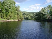
 View of Connecticut River downstream fromEast Hartford
 -

-
 The river near its mouth


.JPG)


Crossings
The Connecticut River is a barrier to travel between western and eastern New England. Several major transportation corridors cross the river including
In literature
Lydia Sigourney's poem "Connecticut River" was published in her 1834 poetry collection.
Wallace Stevens, one of America's most important 20th century poets, lived in Hartford, Connecticut, where he was vice-president of the Hartford Insurance Co. He composed many of his poems, including "The River of Rivers in Connecticut" on his 2.4 mile daily walk to and from his office.[82]
See also
- Equivalent Lands
- The Great Attack, the burning of American ships on the Connecticut River at Essex in 1814
- History of Connecticut
- Lake Connecticut, post-glacial predecessor to Lake Hitchcock
- Lake Hitchcock, post-glacial predecessor to the Connecticut River
- List of rivers of Connecticut
- List of rivers of Massachusetts
- List of rivers of New Hampshire
- List of rivers of Vermont
References
- ^ Michael J. Caduto (November 30, 2015). "With Cooler Water, Better Prospects for Shad Migration?". Northern Woodlands Magazine. Archived from the original on March 4, 2016. Retrieved August 9, 2016.
- ^ "Connecticut River". Geographic Names Information System. United States Geological Survey, United States Department of the Interior.
- ^ "Connecticut River Estuary and Tidal River Wetlands Complex". Ramsar Sites Information Service. Archived from the original on June 14, 2018. Retrieved April 25, 2018.
- ^ Linda Brughelli (October 28, 2014). "Essex - Connecticut". BBC Local: Essex. Archived from the original on October 20, 2016. Retrieved August 9, 2016.
- ^ a b c d e "Watershed Facts". Connecticut River Watershed Council. Archived from the original on August 5, 2016. Retrieved August 9, 2016.
- ^ "USGS Water-Year Summary for Site 01184000". waterdata.usgs.gov. Archived from the original on February 27, 2021. Retrieved January 12, 2021.
- ^ a b c "About the River". Connecticutriver.us. Archived from the original on August 15, 2016. Retrieved August 9, 2016.
- ^ "Connecticut State Name Origin". Statesymbolsusa.org. 10 May 2014. Archived from the original on January 5, 2015. Retrieved November 25, 2014.
- ^ "We Are On Native Land: The Native Names Project Origin". Kestrel Land Trust. 10 June 2021. Retrieved January 16, 2023.
- ^ Alberta Eiseman (August 30, 1998). "THEATER; The Industrialization of the Great River, New England's Longest". The New York Times. Archived from the original on March 6, 2016. Retrieved August 9, 2016.
- ^ "Carte particulière de partie de Long Eyland". Gallica. December 16, 2020. Archived from the original on July 23, 2020. Retrieved May 23, 2020.
- ^ "[carte anglaise de l'est de Long Island]". Archived from the original on July 24, 2020. Retrieved May 23, 2020.
- ^ "Kells Pasture Site, Greenfield MA". Graypape.com. July 22, 2019. Archived from the original on July 22, 2019. Retrieved July 22, 2019.
- ^ "Pequot History". Dickshovel.com. July 15, 1997. Archived from the original on July 28, 2016. Retrieved August 9, 2016.
- ^ "1637 – The Pequot War". The Society of Colonial Wars in the State of Connecticut. Archived from the original on July 28, 2016. Retrieved August 9, 2016.
- ^ "Mattabesic History". Dickshovel.com. November 15, 1997. Archived from the original on April 29, 2016. Retrieved August 9, 2016.
- ^ a b "Mohegan History". Dickshovel.com. July 14, 1997. Archived from the original on August 15, 2016. Retrieved August 9, 2016.
- ^ Meaning "landing place" or "place for unloading canoes."
- ^ "Full text of "Indian place names of New England"". 1962. Archived from the original on October 9, 2014. Retrieved November 25, 2014.
- ^ a b "We Have A New Lodge!!!!!". Pocumtuc Lodge – Western Massachusetts Council, Boy Scouts of America. October 9, 2008. Archived from the original on March 4, 2016. Retrieved August 9, 2016.
- ^ a b "Pocumtuc History". Dickshovel.com. Archived from the original on August 27, 2016. Retrieved August 9, 2016.
- ^ "Pennacook History". Dickshovel.com. Archived from the original on August 27, 2016. Retrieved August 9, 2016.
- ^ "State Recognized Tribes | Vermont Commission on Native American Affairs". Archived from the original on June 2, 2021. Retrieved May 30, 2021.
- ^ Tribe, Nulhegan Abenaki. "Welcome from the Nulhegan Abenaki Tribe at Nulhegan~Memphremagog". Nulhegan Abenaki Tribe. Archived from the original on June 3, 2021. Retrieved May 30, 2021.
- ^ "Elnu Abenaki Tribe - Home". elnuabenakitribe.org. Archived from the original on May 2, 2021. Retrieved May 30, 2021.
- ^ "Our History". Ko'asek (Co'wasuck) Traditional Band of the Sovereign Abenaki Nation. July 13, 2021. Archived from the original on April 17, 2021. Retrieved May 30, 2021.
- ^ "Home". Conseil des Abénakis d'Odanak. Archived from the original on June 2, 2021. Retrieved May 30, 2021.
- ISBN 9780819570529. Archivedfrom the original on December 21, 2019. Retrieved August 9, 2016.
- ^ a b "House of Hope". A Tour of New England: Connecticut. New Netherland Institute. Archived from the original on April 10, 2015. Retrieved August 9, 2016.
- ^ "The Warwick Patent". Colonial Records & Topics. CT State Library. Archived from the original on August 11, 2016. Retrieved August 9, 2016.
- ^ a b c d Barrows, Charles Henry (1911). The history of Springfield in Massachusetts for the young: being also in some part the history of other towns and cities in the county of Hampden. The Connecticut Valley Historical Society. pp. 46–48. US 13459.5.7.
- ^ a b "Why did settlers come to New Hampshire and Vermont, and where did they come from?". Teaching Early Settlement. Flowofhistory.org (Southeast Vermont Community Learning Collaborative). Archived from the original on September 21, 2016. Retrieved August 9, 2016.
- ^ Wardner, p. 13.
- ^ Wardner, p. 41
- ^ Wardner, p. 443
- ^ Van de Water, Frederic. The Reluctant Republic, New York: John Day, 1941. p. 337
- ^ a b c d "Fast Facts". Connecticut River Joint Commissions. Archived from the original on August 8, 2016. Retrieved August 9, 2016.
- ^ [1] Archived December 3, 2008, at the Wayback Machine
- ^ [2] Archived September 26, 2006, at the Wayback Machine
- ^ "Environment & Geography: Written in the Rocks and Sand". Connecticut River Byway Council. Archived from the original on August 28, 2016. Retrieved August 9, 2016.
- ^ a b c d Pike, Helen (April 2013). "Spring Log Drives Through Fifteen-Mile Falls". Vermont's Northland Journal. 12 (1): 20–21.
- ^ Holbrook p.68
- ^ Holbrook p.70
- ^ Holbrook, Stewart H. (1961). Yankee Loggers. International Paper Company. pp. 63–70.
- ^ Wheeler, Scott (September 2002). The History of Logging in Vermont's Northeast Kingdom. The Kingdom Historical.
- OCLC 58055715. Archived from the originalon September 30, 2011. Retrieved November 16, 2011.
- ^ 1634–1699: McCusker, J. J. (1997). How Much Is That in Real Money? A Historical Price Index for Use as a Deflator of Money Values in the Economy of the United States: Addenda et Corrigenda (PDF). American Antiquarian Society. 1700–1799: McCusker, J. J. (1992). How Much Is That in Real Money? A Historical Price Index for Use as a Deflator of Money Values in the Economy of the United States (PDF). American Antiquarian Society. 1800–present: Federal Reserve Bank of Minneapolis. "Consumer Price Index (estimate) 1800–". Retrieved February 29, 2024.
- WGBY(2003)
- ^ "Connecticut River Flood Control Compact" (PDF). US Government Printing Office. June 6, 1953. Archived (PDF) from the original on September 19, 2016. Retrieved August 9, 2016.
- ^ U.S. Supreme Court, Connecticut v. Massachusetts, 282 U.S. 660 (1931)
- ^ "CRWC History". Connecticut River Watershed Council. Archived from the original on August 5, 2016. Retrieved August 9, 2016.
- ^ "MWRA Water System Demand, 1985–2009". Massachusetts Water Resources Authority. Archived from the original on September 25, 2018. Retrieved August 9, 2016.
- ^ a b "Designated Rivers: The Connecticut River". New Hampshire Department of Environmental Services. Archived from the original on May 10, 2016. Retrieved August 9, 2016.
- The Telegraph. May 10, 2012. Archivedfrom the original on September 21, 2016. Retrieved August 9, 2016.
- ^ "Upper Valley Bi-State Regional Chamber of Commerce". Upper Valley Chamber of Commerce. Archived from the original on July 3, 2014. Retrieved July 15, 2014.
- ^ a b "Connecticut Lakes Headwaters". The Trust for Public Land. Archived from the original on June 18, 2018. Retrieved August 2, 2018.
- ^ a b c "171,000-Acre CT Headwaters Now Protected (NH)". The Trust for Public Land. Archived from the original on August 2, 2018. Retrieved August 2, 2018.
- ^ Richard D. Little. "Geological History of the Connecticut River Valley". Earth View LLC. Archived from the original on November 14, 2016. Retrieved August 9, 2016.
- ^ Klekowski, Ed (June 2–4, 2000). "Stop 1-7B: Abyssal Depths in Turner's Falls Area, French King Bridge" (PDF). North Eastern Friends of the Pleistocene Field Conference. Archived from the original (PDF) on October 11, 2016. Retrieved August 9, 2016.
- ^ Susan McGowan. "The Landscape in the Colonial Period". Americancenturies.mass.edu. Archived from the original on April 15, 2016. Retrieved November 25, 2014.
- ^ "Type 6 Conservation Site – Connecticut River Estuary" (PDF). Oldsaybrookct.org. Archived from the original (PDF) on September 24, 2015. Retrieved November 25, 2014.
- ^ "Connecticut River Tidelands". Yankee Magazine. Archived from the original on November 29, 2014. Retrieved November 25, 2014.
- ^ Sam Wotipka (October 10, 2013). "Connecticut River May Soon Flow Freely Again". Scope. MIT Graduate Program in Science Writing. Archived from the original on February 20, 2016. Retrieved August 9, 2016.
- ^ "21 New England municipal electric utilities make historic hydropower purchase commitment". Renewable Energy World. November 13, 2020. Archived from the original on November 18, 2020. Retrieved November 15, 2020.
- ^ "About Holyoke Gas & Electric". Retrieved April 12, 2022.
- ^ "Where did the Holyoke seal come from? (Video)". May 23, 2019. Archived from the original on July 2, 2019. Retrieved July 2, 2019.
- ^ a b Nedeau, Ethan Jay (2008). "Freshwater Mussels and the Connecticut River Watershed" (PDF). Connecticut River Watershed Council, Greenfield, MA. Archived (PDF) from the original on March 26, 2016. Retrieved August 9, 2016.
- ^ "New Life". Archived from the original on June 19, 2019. Retrieved June 19, 2019.
- ^ "Bryozoans". October 15, 2014. Archived from the original on October 15, 2014.
- ^ "A freshwater bryozoan (Lophopodella carteri) - Species Profile". Archived from the original on December 22, 2019. Retrieved June 19, 2019.
- ^ a b Northeast Region Web Development Group. "Fisheries Program - Northeast Region – U.S. Fish & Wildlife Service". Fws.gov. Archived from the original on August 9, 2014. Retrieved November 25, 2014.
- ^ "Species Conservation". US Fish and Wildlife Service. Archived from the original on May 18, 2017. Retrieved June 26, 2018.
- ^ Recovery: Benefits of Salmon Failure
- ^ Weiss-Tisman, Howard (September 4, 2015). "Fish Stocks Rebound After Vermont Yankee Shutdown". www.vpr.org. Retrieved September 23, 2020.
- ^ Kaplan, Thomas (August 30, 2007). "River Watchers, Tackling Speeders and Thin Budgets". The New York Times. Archived from the original on April 21, 2017. Retrieved August 9, 2016.
- ^ "Welcome". Oxbow Marina. Archived from the original on January 27, 2012. Retrieved August 9, 2016.
- ^ "Connecticut River Paddlers' Trail". connecticutriverpaddlerstrail.org. Archived from the original on August 11, 2016. Retrieved August 9, 2016.
- ^ "Archived copy" (PDF). Archived (PDF) from the original on February 1, 2018. Retrieved January 31, 2018.
{{cite web}}: CS1 maint: archived copy as title (link) - ^ "Archived copy" (PDF). Archived (PDF) from the original on February 1, 2018. Retrieved January 31, 2018.
{{cite web}}: CS1 maint: archived copy as title (link) - ^ "News and Information from Northampton, MA by the Daily Hampshire Gazette – GazetteNet.com". Gazettenet.com. Archived from the original on August 9, 2014. Retrieved November 25, 2014.
- ^ "Water Quality Monitoring". Tri-State Connecticut River Targeted Watershed Initiative. Center for Educational Software Development – University of Massachusetts Amherst. Archived from the original on October 17, 2015. Retrieved August 9, 2016.
- ^ The Palm at the End of the Mind, Selected Poems and a Play; Wallace Stevens; Ed. by Holly Stevens
Further reading
- Bacon, Edwin M. (1906). The Connecticut River and the Valley of the Connecticut: Three Hundred and Fifty Miles from Mountain to Sea. New York: G.P. Putnam's Sons. LCC F12.C7 B2.
- Braden, Al (2009). The Connecticut River: A Photographic Journey into the Heart of New England. Middletown CT: Wesleyan University Press. ISBN 978-0-8195-6895-3.
- Delany, Edmund Thomas (1983). The Connecticut River: New England's Historic Waterway. The Globe Pequot Press. ISBN 978-0-87106-980-1.
- Hard, Walter R. (1947). The Connecticut (Rivers of America). New York, Toronto: Rinehart & Company, Inc. LCC F12.C7 H3.
- Roth, Randolph A. (2003). The Democratic Dilemma: Religion, Reform, and the Social Order in the Connecticut River Valley of Vermont, 1791–1850. Cambridge: Cambridge University Press. ISBN 978-0-521-31773-3.
- Vogel, Eve; Lacey, Alexandra (2012). "The New Deal Versus Yankee Independence: The Failure of Comprehensive Development on the Connecticut River, and Its Long-Term Consequences" (PDF). Northeastern Geographer. 4 (2): 65–94.
- Wardner, Henry Steele (1927). The Birthplace of Vermont: A History of Windsor to 1781. New York: Scribner's. LCCN 27014536.
External links
- . Encyclopædia Britannica. Vol. 6 (11th ed.). 1911.
- Connecticut River Watershed Council
- Connecticut River Valley Flood Control Commission
- Connecticut River Museum
- Connecticut Riverfest
- Upper Valley Trails Alliance
- Connecticut River Joint Commissions
- Tri-state Connecticut River Watershed Initiative
- . Collier's New Encyclopedia. 1921.
| Rivers | ||
|---|---|---|