
Sundial (Olympic Mountains)
| Sundial | |
|---|---|
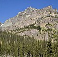
 East aspect, from Royal Basin | |
| Highest point | |
| Elevation | 7,200 ft (2,200 m)[1] |
| Prominence | 80 ft (24 m)[1] |
| Parent peak | Mount Clark (7,528 ft)[2] |
| Isolation | 0.27 mi (0.43 km)[2] |
| Coordinates | 47°49′59″N 123°13′40″W / 47.832961°N 123.227692°W[1] |
| Geography | |
 Sundial Location in Washington  Sundial Sundial (the United States) | |
| Location | class 3 scrambling East Face[3] |
Sundial is a 7,200+ ft (2,190+ m) mountain
class 5 via the South Side Face.[3] The first ascent of the mountain was made in 1944 by Adel and William Degenhardt.[3] The mountain is so named because the time of day can be approximated as an observer in Royal Basin watches the sun's rays make their way down the east face of this mountain in the morning.[4] Precipitation runoff from the mountain drains into Royal Creek which is a tributary of the Dungeness River
.
Climate
Based on the
marine west coast climate zone of western North America.[5] Most weather fronts originate in the Pacific Ocean, and travel northeast toward the Olympic Mountains. As fronts approach, they are forced upward by the peaks of the Olympic Range, causing them to drop their moisture in the form of rain or snowfall (Orographic lift
). As a result, the Olympics experience high precipitation, especially during the winter months. During winter months, weather is usually cloudy, but, due to high pressure systems over the Pacific Ocean that intensify during summer months, there is often little or no cloud cover during the summer. The months July through September offer the most favorable weather for climbing or viewing this peak.
Geology
The Olympic Mountains are composed of obducted clastic wedge material and oceanic crust, primarily Eocene sandstone, turbidite, and basaltic oceanic crust.[6] The mountains were sculpted during the Pleistocene era by erosion and glaciers advancing and retreating multiple times.
Gallery
-
 Sundial centered. Mt. Johnson and Sweat Spire to left
 -
 Sundial, from the southeast
 -
 Sundial in The Needles


See also
References
- ^ a b c d "Sundial". Peakbagger.com.
- ^ a b ""Sundial" - 7,220' WA". listsofjohn.com. Retrieved 2020-07-11.
- ^ a b c Sundial at Climbers Guide Olympics
- ^ Parratt, Smitty (1984). Gods and Goblins: A Field Guide to Place Names of Olympic National Park (1st ed.).
- ISSN 1027-5606.
- ISBN 0-87842-160-2.
External links
- "Olympic National Park". National Park Service.
- Sundial weather: National Weather Service