
Syvash
| Syvash | |
|---|---|
Salgir | |
| Basin countries | |
| Max. length | 200 km (120 mi) |
| Max. width | 35 km (22 mi) |
| Surface area | 2,560 km2 (990 sq mi) |
| Average depth | 0.5–1 m (1.6–3.3 ft) |
| Max. depth | 3 m (9.8 ft) |
| Salinity | 22-87‰ |
| Official name | Central Syvash |
| Designated | 11 October 1976 |
| Reference no. | 115[1] |
| Official name | Eastern Syvash |
| Designated | 23 November 1995 |
| Reference no. | 769[2] |
The Syvash or Sivash
Overview
The Syvash nearly cuts the Crimean Peninsula off from the mainland, serving as a natural border for Russia's Republic of Crimea. The long (110 km (68 mi)) and narrow (0.27–8 km (0.2–5.0 mi)) Arabat Spit runs to its east, separating it from the Sea of Azov. The two bodies are connected in the north at the Henichesk Strait beside the port of Henichesk. To its west, the Isthmus of Perekop separates it from the Black Sea and connects Crimea to the mainland.

The Syvash is extremely shallow. The deepest place is about 3 meters (10 ft), with most areas between 1⁄2–1 m (1 ft 8 in – 3 ft 3 in) deep. The bottom is covered with
The Syvash is sometimes divided into the Western Syvash and Eastern Syvash. These are connected to each other by the
History
During the
Flora
The Syvash may appear red in color due to the salt-tolerant micro-alga Dunaliella salina.[4]
The eastern parts of the Syvash contain less salt and are home to reeds and other wetland vegetation.[5]
The large islands in the Central Syvash are mainly covered with
The shores of the Syvash contains a large number of salt-tolerant vegetation, including glasswort, Tripolium, plantains, sea lavender (Limonium caspium), saltbush (Atriplex aucheri).[5]
Gallery
-
 Crimea
 -
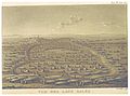 The Salinas (c. 1820)
 -
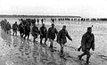 Soviet soldiers crossing the Syvash in late 1943
 -
 Illustration of the shallowness of water in the Syvash
 -
 Syvash waters turned reddish by Dunaliella salina microalgae
 -
 View of Lake Lemuria, one of the bodies of water tinted by algae

_p3.162_VUE_DES_LACS_SALES.jpg)


References
- ^ "Central Syvash". Ramsar Sites Information Service. Archived from the original on 6 September 2015. Retrieved 25 April 2018.
- ^ "Eastern Syvash". Ramsar Sites Information Service. Archived from the original on 9 December 2015. Retrieved 25 April 2018.
- ^ Baynes, T. S., ed. (1878). . Encyclopædia Britannica. Vol. 3 (9th ed.). New York: Charles Scribner's Sons. p. 169.
- ^ Siwaschsee. 3 September 2020. Archived from the original on 25 September 2014. Retrieved 10 May 2014.
- ^ ISBN 9058829960. Archived from the original(PDF) on 2014-05-12.
External links
![]() Media related to Syvash at Wikimedia Commons
Media related to Syvash at Wikimedia Commons