
Tamaulipan mezquital
| Tamaulipan mezquital | |
|---|---|
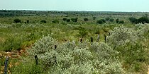
.jpg) Tamaulipan thornscrub, Webb County, Texas, USA (10 June 2016) | |
 | |
| Ecology | |
| Realm | Nearctic |
| Biome | Deserts and xeric shrublands |
| Borders | List |
| Bird species | 340 Hot semi-arid (BSh) |
| Conservation | |
| Habitat loss | 18.449%[1] |
| Protected | 0.68%[1] |
The Tamaulipan mezquital (Spanish: Mezquital Tamaulipeco) is a deserts and xeric shrublands ecoregion in the Southern United States and northeastern Mexico. It covers an area of 141,500 km2 (54,600 sq mi),[2] encompassing a portion of the Gulf Coastal Plain in southern Texas, northern Tamaulipas, northeastern Coahuila, and part of Nuevo León.
Distribution
The
Geography

The Bordas Escarpment transects this ecoregion, running from near the southern limit northwest to the vicinity of Rio Grande City, Texas, arching back northeast to the vicinity of Choke Canyon Reservoir in Texas. The region east of the Bordas Escarpment is flat with deep, sandy soils, of which vast areas both north and south of the border have been converted to agricultural use. West of the Bordas Escarpment the topography changes to gently rolling hills with a thin layer of high calcium soil over a thick layer of caliche. Some large portions of the west are poorly suited for cultivation but good for ranching and excellent wildlife habitat.[3]
A series of
The Coastal Sand Plain, sometimes referred to as the "Wild Horse Desert", is a region of Quaternary sand deposits extending about 60 miles inland from the Laguna Madre. It is bordered by Baffin Bay to the north and the Lower Rio Grande Valley to the south. Quaternary to Tertiary marine sedimentary strata, which may be exposed in western areas, underlie the sand sheet. The sand sheet is six feet deep in many places with maximum dune elevations reaching 30 feet. Although the area is generally flat, the unstable sands often form a dune and swale topography where vegetated dunes are interspersed with active, unstable, wind-blow dunes. The active dunes attain areas as large as 250 acres, predominantly in the eastern third. Grasslands cover much of the sand plain where seacoast bluestem (Schizachyrium littorale) is dominant in all but the wettest areas. These grasslands are banded with live oak (Quercus virginiana) groves, forming dense forest in spots, and smaller honey mesquite (Prosopis glandulosa) mottes in discontinuous belts which are sometimes connected with one another and collectively cover at least a quarter of the sand sheet. Numerous ephemeral, internally drained ponds form where subsidence and blow-outs occur.[5]
Hydrology: The region is generally semi-arid however, various
.jpg)
Several rivers cross the region, all flowing eastward to the
A number of large lakes occur in the region, but they were all constructed in the decades fallowing the Second World War in the 20th century. These include:
Tamaulipan mezquital gallery
-
 Grasslands with Wild Olive (Cordia boissieri), Jim Hogg County, Texas, USA (10 April 2016)
 -
 Mesquite woodlands, Sabal Palm Sanctuary, Cameron County Texas (11 April 2016).
 -
 Bentsen-Rio Grande Valley State Park, Hidalgo County, Texas, USA (15 April 2016)
 -
 State Highway 16, Duval County, Texas, USA. (16 April 2016)
 -
 Tamaulipan thornscrub, private ranchland, Webb County, Texas (10 June 2016).
 -
 Old growth sabal palm grove, Sabal Palm Sanctuary, Cameron County, Texas, USA (11 April 2016).
 -
 Tamaulipan thornscrub, State Highway 4, Cameron Cameron County, Texas, USA (11 April 2016)
 -
 Trail through mature thornscrub forest in Santa Ana National Wildlife Refuge, Hidalgo County, Texas, USA (14 April 2016).
 -
 Road in thornscrub vegetation, Yturria Brush National Wildlife Refuge, Hidalgo County, Texas, USA (15 April 2016)
 -
 Rio Grande southeast of Falcon Reservoir, Municipality of Mier, Tamaulipas, Mexico (12 August 2007)
 -
 Thornscrub south of Reynosa, Municipality of Reynosa, Tamaulipas, Mexico (13 August 2007)
 -
 Sierra San Carlos, Municipality of San Carlos, Tamaulipas, Mexico (14 July 2007)
 -
 Sierra San Carlos, with a pine tree (Pinus teocote) on left, Municipality of San Carlos, Tamaulipas, Mexico (12 July 2007)
 -
 Thornscrub ranchland west of Tepehuajes, Municipio Soto La Marina, Tamaulipas, Mexico (20 May 2002)
,_FM_1017,_Jim_Hogg_County,_Texas,_USA_(10_April_2016).jpg)

.jpg)
.jpg)


.jpg)
.jpg)
.jpg)
.jpg)
.jpg)
.jpg)
,_Municipality_of_San_Carlos,_Tamaulipas,_Mexico_(12_July_2007).jpg)
.jpg)
Flora
This semi-arid region is dominated by Mezquital (Spanish for a mesquite grove
Grasslands with sparsely scattered trees and shrubs occur on level to gently rolling sites with sandy soils. These are dominated by dense
Woodlands occur in places with a well-developed canopy over an understory of grasses. The grasses in these communities contain a layer of taller species such as hooded windmill grass (
Xeric rocky uplands with shallow calcareous soils on
Saline lakes and saline thornscrub occur in some interior, low-lying areas with interior draining basins, created by runoff and evaporation. Lakebeds (often dry) may lack vegetation or have sparse
,_Rio_Pil%C3%B3n_near_Villagr%C3%A1n,_Municipality_of_Villagr%C3%A1n,_Tamaulipas,_Mexico_(9_August_2005).jpg)
Riparian zones and floodplains can support luxuriant forest on the
,_State_Highway_4,_Cameron_County,_Texas,_USA_(11_April_2016).jpg)
Cacti: This region is rich in cacti diversity. In addition to wide-ranging species like lace cactus (
Fauna
Mammals: This region once hosted an impressive number of carnivores but, most were very rare, or entirely
Other mammals found in the region include the collared peccary (
-
 Collared peccary (Pecari tajacu), Hidalgo Co. Texas (4 Feb 2010).
 -
 Rio Grande ground squirrel (Ictidomys parvidens) Cameron Co. Texas (12 April 2016).
 -
 Black-tailed jackrabbit (Lepus californicus), Texas (13 June 2006).
 -
 Ocelot (Leopardus pardalis) with tracking caller, Laguna Atascosa National Wildlife Refuge, Cameron Co. Texas.
 -
 White-nosed coati (Nasua narica), Mexico (5 Sept 2009).
 -
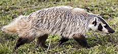 American badger (Taxidea taxus), Marin Co., California (25 Nov 2007).
,_Bentsen-Rio_Grande_Valley_State_Park,_Hidalgo_Co._Texas_(4_Feb_2010)._A.jpg)
_Cameron_Co._Texas_(12_April_2016).jpg)

_Laguna_Atascosa_National_Wildlife_Refuge,_Texas.jpg)

_cropped.jpg)
Birds: The southern part of the ecoregion is an Endemic Bird Area
-
 Plain chachalaca (Ortalis vetula), Municipality of Montemorelos, Nuevo León (9 April 2009).
 -
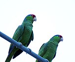 Red-crowned Amazon (Amazona viridigenalis), Cameron Co. Texas (15 Mar 2016).
 -
 Ferruginous pygmy owl (Glaucidium brasilianum), King Ranch, TX (15 Mar 2016).
 -
 Buff-bellied hummingbird (Amazilia yucatanensis), Sabal Palm Sanctuary, Cameron Co. Texas (21 Sept. 2015).
 -
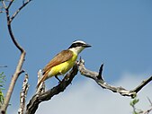 Great kiskadee (Pitangus sulphuratus). Bee Co., Texas (3 July 2011).
 -
 Long-billed thrasher (Toxostoma longirostre), Texas, USA (20 Feb. 2017).
 -
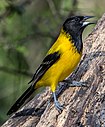 Audubon's oriole (Icterus graduacauda), Starr Co. Texas (1 Feb 2014).

.jpg)
.jpg)
_Sabal_Palm_C.jpg)

.jpg)
.jpg)
Reptiles: The American alligator (
-
 Rose-bellied lizard (Sceloporus variabilis marmoratus), Hidalgo County, Texas, USA (14 April 2016).
 -
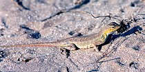 Keeled earless lizard (Holbrookia propinqua), municipality of Soto La Marina, Tamaulipas, Mexico (20 May 2002).
 -
 Texas banded gecko (Coleonyx brevis), Webb County Texas, USA (10 June 2016).
 -
 Texas Tortoise (Gopherus berlandieri), northern Tamaulipas, Mexico (9 July 2007).
 -
 Northern cat-eyed snake (Leptodeira septentrionalis), Municipality of Victoria, Tamaulipas, Mexico (7 Aug 2003).
 -
 Mexican milksnake (Lampropeltis annulata), Municipality of Victoria, Tamaulipas (30 Oct 2003).
 -
 Western diamondback rattlesnake (Crotalus atrox), Municipality of Padilla, Tamaulipas, Mexico (29 May 2004).


,_Municipality_of_Victoria,_Tamaulipas_(30_Oct_2003).jpg)

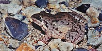
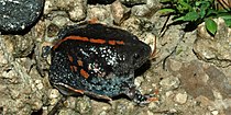
Amphibians: In spite of the semi-arid environment, enough wetlands are present to support salamanders such as the black-spotted newt (
-
 Mexican Treefrog (Smilisca baudinii), Municipality of Abasolo, Tamaulipas, Mexico (18 May 2002).
 -
 White-lipped Frog (Leptodactylus fragilis) Municipality of Victoria, Tamaulipas, Mexico (12 August 2003).
 -
 Couch's Spadefoot (Scaphiopus couchii), Cameron County, Texas, USA (11 April 2016).
 -
 Black-spotted Newt (Notophthalmus meridionalis), Santa Ana NWR, Hidalgo Co, Texas (14 April 2016).
 -
 Cane Toad (Rhinella horribilis), Municipality of Soto La Marina, Tamaulipas, Mexico (17 May 2002).
 -
 Sheep Frog (Hypopachus variolosus), Municipality of Victoria, Tamaulipas, Mex (12 August 2003).
 -
 Burrowing Toad (Rhinophrynus dorsalis), Municipality of Reynosa, Tamaulipas, Mexico (8 October 2007).


,_Santa_Ana_NWR,_Hidalgo_Co,_TX,_USA,_(26.0821%C2%B0N,_98.1354%C2%B0W),_14_April_2016.jpg)


Fishes: Two species, the San Ignacio pupfish (
-
 Sailfin molly (Poecilia latipinna)
 -
 Rio Grande darter (Etheostoma grahami), Val Verde Co., Texas (22 June 2006).
 -
 Gulf killifish (Fundulus grandis), male, Dixie Co., Florida.
 -
 Rio Grande silvery minnow (Hybognathus amarus)
 -
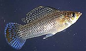
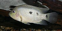 Rio Grande cichlid (Herichthys cyanoguttatus), Texas
 -
 Longnose gar (Lepisosteus osseus)
 -
 Alligator gar (Atractosteus spatula)


,_male,_Dixie_Co,_Florida_(27_Dec_2013).jpg)

_II.jpg)
.jpg)
_I.jpg)
Protected areas
Nature preserves are numerous in the region, however many are relatively small tracts of land concentrated on the north side of the
Beyond the Lower Rio Grande Valley of Texas protected lands include the
In Tamaulipas, Mexico protected areas include western portions of the Laguna Madre y Delta del Rio Bravo and Parras de la Fuente, Reserva de la Paloma de Ala Blanca (ca. 23.8888°N, 98.5000°W), and in Coahuila, Mexico the Parque Nacional Los Novillos. Many of the protected lands in Mexico are actually "paper parks" owned and administer by local ejidos and municipalities, with few resources devoted to their management, no accommodations, no facilities or trails for visitors, and little management or enforcement of wildlife regulations. Nonetheless, such parks do limit land usage and development, and thus provide a significant degree of protection for habitat and the flora and fauna within.[41][42][43]
See also
References
- ^ a b c d
Hoekstra, J. M.; Molnar, J. L.; Jennings, M.; Revenga, C.; Spalding, M. D.; Boucher, T. M.; Robertson, J. C.; Heibel, T. J.; Ellison, K. (2010). Molnar, J. L. (ed.). The Atlas of Global Conservation: Changes, Challenges, and Opportunities to Make a Difference. ISBN 978-0-520-26256-0.
- ^ a b c d e f g h "Tamaulipan mezquital". Terrestrial Ecoregions. World Wildlife Fund. Retrieved 2010-11-25.
- ^ a b Fulbright, Timothy E., and Fred C. Bryant (2004).The Last Great Habitat. A Special Publication of the Caesar Kleberg Wildlife Research Institute, Texas A&M University-Kingsville. Special Publication No. 1, 1-32 pp.
- ISBN 0-19-506674-X
- ^ Fuibright, Timothy E., David D. Diamond, John Rappoie, and Jim Norwine. 1990. Coastal Sand Plain of Southern Texas. Rangelands 12(6): 337-340.
- ISBN 1-58544-133-3
- ISBN 1-58544-133-3
- ISBN 978-1-62349-306-6
- ^ a b Texas Water Development Board, TWDB Maps: Major Surface Water Features.
- ^ ISBN 970-621-492-5
- ISBN 0-02-522910-9
- ^ a b c d e Blair, W. Frank. (1950). The Biotic Provinces of Texas. Texas Journal of Science. 2(1): 93-117.
- ^ Martin, Paul S., C. Richard Robins, and William B. Heed. 1954. Birds and Biogeography of the Sierra de Tamaulipas, an Isolated Pine-Oak Habitat.The Wilson Bulletin.Vol. 66, No. 1: 38-57.
- ^ Richardson, Alfred and Ken King. 2011. Plants of Deep South Texas, A Field Guide to the Woody and Flowering Species. Texas A&M University Press. College Station, Texas. xii, 457 pp.
- ^ a b c d Texas Parks and Wildlife (& Nature Serve Explorer), Ecological Mapping Systems of Texas: Tamaulipan Savanna Grassland (Accessed: 18 August 2020).
- ^ a b c Texas Parks and Wildlife (& Nature Serve Explorer), Ecological Mapping Systems of Texas: Tamaulipan Calcareous Thornscrub (Accessed: 18 August 2020).
- ^ Texas Parks and Wildlife (& Nature Serve Explorer), Ecological Mapping Systems of Texas: Tamaulipan Mixed Deciduous Thornscrub (Accessed: 18 August 2020).
- ^ Texas Parks and Wildlife (& Nature Serve Explorer), Ecological Mapping Systems of Texas: Tamaulipan Saline Lake (Accessed: 18 August 2020).
- ^ Texas Parks and Wildlife (& Nature Serve Explorer), Ecological Mapping Systems of Texas: Tamaulipan Saline Thornscrub (Accessed: 18 August 2020).
- ^ Cram, Silke, Irene Sommer, Luis-Miguel Morales, Oralia Oropeza, Estela Carmona, and Francisco Gonzalez-Medrano. 2006. Suitability of the vegetation types in Mexico's Tamaulipas state for the siting of hazardous waste treatment plants. Journal of Environmental Management. 80 (2006): 13-24.
- ^ Texas Parks and Wildlife (& Nature Serve Explorer), Ecological Mapping Systems of Texas: Tamaulipan Closed Depression Wetland (Accessed: 18 August 2020).
- ^ Gobierno El México, Parque Nacional El Sabinal
- ^ Texas Parks and Wildlife (& Nature Serve Explorer), Ecological Mapping Systems of Texas: Tamaulipan Floodplain (Accessed: 18 August 2020).
- ^ Texas Parks and Wildlife (& Nature Serve Explorer), Ecological Mapping Systems of Texas: Rio Grande Delta Thorn Woodland and Shrubland (Accessed: 18 August 2020).
- ^ Texas Parks and Wildlife (& Nature Serve Explorer), Ecological Mapping Systems of Texas: Tamaulipan Palm Grove Riparian Forest (Accessed: 18 August 2020).
- ISBN 978-1-60344-108-7
- ISBN 978-0-9538134-8-3
- ^ World Wildlife Fund, ed. (2001). "Tamaulipan mezquital". WildWorld Ecoregion Profile. National Geographic Society. Archived from the original on 2010-03-08. Retrieved 2010-11-25.
- ^ ISBN 0-292-70241-8
- ^ ISBN 1-4214-0843-0
- ^ Stattersfield, A.J., M.J. Crosby, A.J. Long and D.C. Wege. (1998). Endemic Bird Areas of the World: Priorities for Biodiversity Conservation. Birdlife Conservation Series No. 7, Cambridge, UK.
- ISBN 0-19-854012-4
- ISBN 0-517-03288-0
- ^ ISBN 978-1-62349-306-6
- ISBN 0-292-79130-5
- ISBN 0-19-515672-2
- ISBN 0-226-52604-6
- ISBN 978-1-58544-570-7
- ^ Texas Parks and Wildlife: Las Palomas WMA, Lower Rio Grande Valley Units
- ^ U. S. Fish and Wildlife Service: Lower Rio Grande Valley National Wildlife Refuge, Texas
- ^ UNESCO: Laguna Madre y Delta Río Bravo
- ^ Gobierno del Estado de Tamaulipas: Paloma Alas Blancas
- ^ Gobierno del México: 76 aniversario del Parque Nacional Los Novillos