Amnon Ben-Tor (1970), Pierre de Miroschedji (1980), Paz Yitzhak (2014), Mizrahi Sivan (2014), Adawi Zubair (2014), Haber Michal (2014), Radshkovsky Igal (2014), Zilberbod Irina (2014), Greenvald Roie (2014), Sapir Neria (2014), Yoav Tsur (2014), Eirikh-Rose Anna (2014)
Condition
Ruined
Ownership
Public
Public access
Yes
Tel Yarmuth (also Tel Yarmouth and Tel Yarmut; Hebrew name) or Khirbet Yarmuk (Arabic name) is an ancient Near East archaeological site in Israel located 25 kilometers southwest of Jerusalem and near modern Beit Shemesh. It is a large primarily single-period (EB II/III) site and has been suggested as possibly being the city of Jarmuth, being only a tentative identification, as it is based solely on the similarity of the Hebrew name with the Arabic name and its areal location.[1][2]
History
Early Bronze Age
Chronologically the city reached its peak at the same time as the
. After that the city was abandoned, with modest occupation in later periods.
Early Bronze period material from Tel Yarmuth has been radiocarbon dated and is being used to support the contention that EB III ended around 2500 BC. Samples tested were "3 from Final EB IB, 15 from EB II, and 19 from EB III". Results were Final EB IB to EB II transition between 3030 and 2960 BC, EB II to EB III transition between 2980 and 2910 BC.[3][4][5]
Early Bronze IB
The only notable EB IB find was a basalt spindle whorl.[6]
Early Bronze II-III
The entire site including the lower town was heavily occupied in the Early Bronze (EB) II and III periods.[7][8] The site was abandoned around 2400 BC, during EB III.[6]
Early Bronze Age vessel found at Tel Yarmuth
The EB II and III monumental construction includes the large "White Building", a plastered masonry broad-room temple with a side altar. In this period two large palaces were built with one, Palace B1, measuring 1750 square meters and the other, Palace B2, measuring 6000 square meters.[9] At its peak the city had massive sophisticated fortifications and a large main city gate (Area E). The first city wall (Wall A) was made of stone, was 6 meters deep and is preserved to 4 meters in height. A larger wall (Wall B) was later added outside of that built of cyclopean construction. The fortifications were subsequently improved even further.[7][8] A number of EB III flint Canaanite blades, believed to be used as sickle inserts or in threshing, were found.[6]
Middle Bronze
The acropolis was lightly re-occupied, based on potsherd finds, in the Middle Bronze IIA.
Late Bronze
The site saw some occupation in the Late Bronze II. It included 13th century BC Mycenaean and Cypriot sherds. The only other epigraphic find was a hoe with a partial hieroglyphic inscription in a hoard of bronze objects, mostly fragmentary. They were dated to the time of the 19th Dynasty (12th century BC) and may not be in their original context.[6]
Iron Age
Somewhat more substantial building occurred on the acropolis in Iron I times. Finds from that period included a 2nd-century BC cooking pot with a yršlm (Jerusalem) stamp.[10][11]
In the
Shefelah, or what is a place of transition between the mountainous region and the coastal plains. Also in the Hebrew Bible, Joshua 12:7–11, the king of Yarmuth (Jarmuth) was slain by Joshua and the Israelites
during their conquest of the land of Canaan.
Period of the monarchy
In the late 8th-century BC (ca. 700 BC), Yarmuth was in the territorial domain belonging to King Hezekiah. In the 14th-year of King Hezekiah's reign, Sennacherib embarked on his third military campaign, this time against the cities of the Levant, including against the king of Sidon and against Jerusalem in Judah, where King Hezekiah was besieged, based on 2 Kings 18:137 in the Hebrew Bible. Many of the king's important cities in Judah were at that time taken by Sennacherib and given over to other potentates faithful to Sennacherib. Although Yarmuth is not specifically named in the prism (Sennacherib's Annals) detailing Sennacherib's exploits, it can be assumed by the account that the city did not go unscathed:
"As for Hezekiah, the Jew, who did not submit to my yoke, forty-six of his strong, walled cities, as well as the small cities in their neighborhood, which were without number...I besieged and took. Two-hundred thousand, and one-hundred and fifty people, great and small, male and female, horses, mules, asses, camels, cattle and sheep, without number, I brought away from them and counted as spoil. Himself, like a caged bird, I shut up in Jerusalem his royal city... The cities of his, which I had despoiled, I cut off from his land and to Mitinti, king of Ashdod, [and to] Padi, king of Ekron, [and to] Silli-bel, king of Gaza, I gave. And (thus) I diminished his land."[12]
Persian period
The only possible record for Yarmuth for this time-period (c. 539–331 BC) is taken from the
During the Hellenistic and Roman periods, no records of events concerning Yarmuth have survived, although potsherds from the Roman period have been discerned.
Some Early Byzantine era terraces and potsherds were found in the lower town area.[14]
Archaeology
The site is about 18 hectares (44 acres) in extent. The high point, 1.8 hectares (4.4 acres) in area, lies on the eastern side with a lower town extending to the west. The site is roughly 640 by 420 meters.[15]
The mound, then known as Khirbet Yarmuk, was visited by French archaeologist Victor Guérin in 1863.[15] American archaeologist Frederick J. Bliss, who visited the site at the start of the 20th-century, remarked seeing interior walls of a building that were 4 feet and 6 inches thick in diameter, and that early Roman and Arab potsherds could be seen there.[16] A survey of the site was conducted by Adam Druks in 1963.[17] A. Ben-Tor conducted a sounding there in 1970 on behalf of the Hebrew University.[18]
In 2014, extensive excavations were conducted at the site by the Israel Antiquities Authority (IAA). After 2016 the site was declared a national park and since then excavations have been conducted, under the auspices of the Israel Antiquities Authority, in preparation for public access.[26][27] An extensive geophysical survey of the lower town was also completed.
See also
Cities of the ancient Near East
Gallery
Ramp leading to the gatewayBase of column from ancient structure
Dressed stone at Tel Yarmuth
Fieldstones embedded in mortar at Tel Yarmuth
Foundation of house showing three bases of columns
Foundations of large house
General view of stone walls at Tel Yarmuth
Jambs of doorway
General layout of excavated ruin
Remains of column base
Ruins of Yarmuth
Thick stone wall at Tel Yarmuth
View of archaeological site
General view of ruins
Defensive wall of Tel Yarmuth
Walled city of Yarmuth (Jarmuth)
Walled structures
References
OCLC 6250553. (original Hebrew edition: 'Land of Israel in Biblical Times - Historical Geography', Bialik Institute
^J. Regev-P. de Miroschedji-E. Boaretto, "Early Bronze Age Chronology. Radiocarbon Chronological Models from Tel Yarmuth (Israel)", Radiocarbon 54, pp. 505-524, 2012
^[1] Regev, J., de Miroscedji, P., Greenberg, R., Braun, E., Greenhut, Z., and Boaretto, E., "Chronology of the Early Bronze Age in the South Levant: New Analysis for a High Chronology, Radiocarbon", 54(3-4), pp. 525-566, 2012
^Regev, Johanna, et al., "Wiggle-matched 14C chronology of Early Bronze Megiddo and the synchronization of Egyptian and Levantine chronologies", Ägypten Und Levante / Egypt and the Levant, vol. 24, 20, pp. 241–64, 2014
^ abcdP. de Miroschedji "The Late EB III Palace at Tel Yarmuth: A Descriptive Summary", Eretz-Israel, vol.27, pp.153–170, 2003
^ abP. de Miroschedji, "The Early Bronze Age Fortification System at Tel Yarmuth, an Interim Statement", EI 20, pp. 48-61, 1990
^ ab[2] P. de Miroschedji., "The Early Bronze Age Fortifications at Tel Yarmut – An Update", Publication Name: Eretz-Israel, Archaeological, Historical and Geographical Studies, vol. 33 (Stager Volume), 2018
^Vieweger, Dieter, "The Early Bronze Age I-III (3600---2300 BC)", Early and Middle Bronze Age. (Strata 25-17), edited by Dieter Vieweger and Jutta Häser, Gütersloh: Gütersloher Verlagshaus, pp. 15-156, 2019
^Lipschits, Oded, Gadot, Yuval, Arubas, Benjamin and Oeming, Manfred, "Third Building Phase (Late 6th or 5th Century BCE)", What Are the Stones Whispering?: Ramat Raḥel: 3,000 Years of Forgotten History, edited by Oded Lipschits, Yuval Gadot, Benjamin Arubas and Manfred Oeming, University Park, USA: Penn State University Press, pp. 98-116, 2017
^Richardson, H.N., "A Stamped Handle from Khirbet Yarmuk", Bulletin of the American Schools of Oriental Research192, pp. 12–16, 1968
^P. de Miroschedji, "Yarmuth: The Dawn of City-States in Southern Canaan", Near Eastern Archaeology, 62(1):2, March 1999 DOI : https://doi.org/10.2307/3210719
^Druks, A., "Survey of Tel Yarmut", Hadashot Arkheologiyot 5:20-21, 1963 (Hebrew)
^Ben-Tor A., "Two Burial Caves of the Proto-Urban Period at Azor, 1971; The First Season of Excavations at Tell-Yarmuth", 1970 (Qedem 1). Jerusalem: Institute of Archaeology, The Hebrew University of Jerusalem, 1975
^P. de Miroschedji, "Yarmouth 1. Rapports sur les trois premières campagnes de fouilles à Tel Yarmouth (Israël) (1980-1982)", Syria, 67-2 pp. 523-524, 1990
^P. de Miroschedji, "Tel Yarmut, (1992)", Excavations and Surveys in Israel 14, pp. 105-108, 1994
^P. de Miroscheddji, "Tel Yarmut, 1992", IEJ42, pp. 265–72, 1992
^P. de Miroschedji., "fouilles de tel yarmouth: résultats des 11E, 12e et 13e campagnes de fouilles (1996-1999): académie des inscriptions & belles-lettres. comptes rendus de séances de l'année", iss. 2, pp. 679-717, 2000
^P. de Miroschedji,"Tel Yarmut, 1997", IEJ, vol. 48, pp. 136–144", 1998
^P. de Miroschedji, "Fouilles de Tel Yarmouth: Résultats des travaux de 2003 à 2009 (14th-18th campagnes)", in: Comptes rendus des séances de l'Académie des Inscriptions et Belles-Lettres, 157e année, N. 2, pp. 759-796, 2013
^Sivan Mizrahi et al., "Tel Yarmut, Site 203A: Preliminary Report.", Hadashot Arkheologiyot: Excavations and Surveys in Israel, vol. 129, 2017"
^Shalev, Omer, and Amir Golani, "Tel Yarmut: Preliminary Report.” Hadashot Arkheologiyot: Excavations and Surveys in Israel, vol. 130, 2018. JSTOR, https://www.jstor.org/stable/26691759
Further reading
Connan, Jacques, et al., "Bitumens from Tell Yarmuth (Israel) from 2800 BCE to 1100 BCE: A unique case history for the study of degradation effects on the Dead Sea bitumen.", Organic Geochemistry 168, 2022
Jasmin, M., "L’étude de la transition du Bronze récent II au Fer I en Palestine méridionale", Oxford: BAR Publishing, 2006
Jasmin, M., "The Political Organization of the City-States in Southwestern Palestine in the Late Bronze Age IIB (13th Century bc)", in “I Will Speak the Riddles of AncientTimes”: Archaeological and Historical Studies in Honor of Amihai Mazar on the Occasion of His Sixtieth Birthday, eds. A. M. Maeir, and P. D. Miroschedji, Winona Lake: Eisenbrauns, pp. 161–91, 2006
Levy-Reifer, Ayelet and Paz, Itzhak, "Tel Yarmouth, its Environs and their Reflection on the Urban Landscape of the Shephelah in the Early Bronze Age III", Tell it in Gath. Studies in the History and Archaeology of Israel. Essays in Honor of Aren M. Maeir on the Occasion of his Sixtieth Birthday, hrsg. v. Itzhaq Shai (Ägypten und Altes Testament 90)., pp. 77-99, 2018
Manclossi Francesca, Rosen Steve A., De Miroschedji Pierre, "The Canaanean Blades from Tel Yarmuth, Israel: A technological analysis", Paléorient, vol. 42, n°1. pp. 49–74, 2016 DOI : https://doi.org/10.3406/paleo.2016.5693
Miroschedji P. de, "Yarmouth 1: Rapport sur les trois Premières campagnes de fouilles à Tel Yarmouth (Israël) (1980–1982)", Editions Recherche sur les Civilisations, Mémoire 76, Paris, 1988
de Miroschedji, Pierre, "Tell Yarmouth, un site du Bronze ancien en Israel", Paléorient, vol. 6, pp. 281–86, 1980
Paz, Y., Mizrahi, S., and Grossman, L., "Ancient Fields: An EB III Case Study from Tel Yarmuth", New Studies in the Archaeology of Jerusalem and Its Region, 9, pp. 91–98, 2015
Salavert, Aurélie. "Olive Cultivation and Oil Production in Palestine during the Early Bronze Age (3500—2000 B.C.): The Case of Tel Yarmouth, Israel.", Vegetation History and Archaeobotany, vol. 17, pp. S53–61, 2008


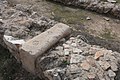 Dressed stone at Tel Yarmuth
 Fieldstones embedded in mortar at Tel Yarmuth
 Foundation of house showing three bases of columns
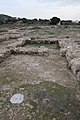 Foundations of large house
 General view of stone walls at Tel Yarmuth
 Jambs of doorway
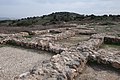 General layout of excavated ruin
 Remains of column base
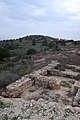 Ruins of Yarmuth
 Thick stone wall at Tel Yarmuth
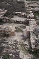 View of archaeological site
 General view of ruins
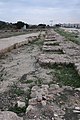 Defensive wall of Tel Yarmuth
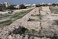 Walled city of Yarmuth (Jarmuth)
 Walled structures


