
Tempe Terra


Tempe Terra is a heavily cratered highland region in the northern hemisphere of the planet Mars. Located at the northeastern edge of the Tharsis volcanic province, Tempe Terra is notable for its high degree of crustal fracturing and deformation. The region also contains many small shield volcanoes, lava flows, and other volcanic structures.
The region is named after the
Location and description
Tempe Terra is located in the eastern half of the
Geology
Tempe Terra occupies a transition zone between the old, heavily cratered highlands of the Martian south and the geologically younger, lowland terrain of the north. Tempe Terra contains the northernmost exposures of ancient highland crust on the planet.
There is evidence of valleys in Tempe Terra, including stream meanders, as in the image below.
-
 Hanging valley, as seen by HiRISE under HiWish program This may have been a waterfall at one time.
 -
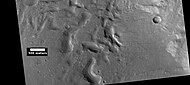
 Channels, as seen by HiRISE under HiWish program. Stream appears to have eroded through a hill.
 -
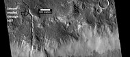
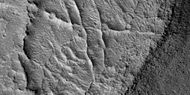
 Stream meander and cutoff, as seen by HiRISE under HiWish program.


Gullies
Martian gullies are small, incised networks of narrow channels and their associated downslope
-
 A variety of gullies originating at different levels are visible in this HiRISE image that was taken under the HiWish program.
 -
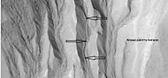 This enlargement of a small part of the previous image shows terraces along a gully channel. The terraces were created when a new channel cut through the old surface. This means that the gully was not in a single event. Water must have flowed more than once in this location.
 -
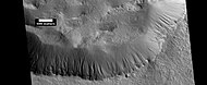 Gullies in a crater. Some seem to be young, others are well developed. Picture was taken by HiRISE under the HiWish program.
 -
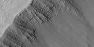
 Gullies along mesa wall in North Tempe Terra, as seen by HiRISE under HiWish program
 -
 Close view of gully apron, as seen by HiRISE under HiWish program Note this is an enlargement of the previous image.
 -
 Close view of gully alcove, as seen by HiRISE under HiWish program Note this is an enlargement of a previous image.
 -
 Gullies on wall of mesa, as seen by HiRISE under HiWish program


Linear ridge networks
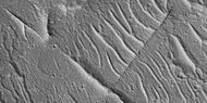
Linear ridge networks are found in various places on Mars in and around craters.[6] These features have also been called "polygonal ridge networks," "boxwork ridges", and "reticulate ridges."[7] Ridges often appear as mostly straight segments that intersect in a lattice-like manner. They are hundreds of meters long, tens of meters high, and several meters wide. It is thought that impacts created fractures in the surface, these fractures later acted as channels for fluids. Fluids cemented the structures. With the passage of time, surrounding material was eroded away, thereby leaving hard ridges behind.
-
 Wide view of ridge network, as seen by HiRISE under HiWish program
 -
 Close view of ridge networks, as seen by HiRISE under HiWish program Arrow points to small, straight ridge.
 -
 Close view of small and large ridges, as seen by HiRISE under HiWish program
 -
 Close view of small and large ridges, as seen by HiRISE under HiWish program


Pits and troughs
Pits and troughs are common on Mars. Large troughs (long narrow depressions) are called fossae in the geographical language used for Mars. This term is derived from Latin; therefore fossa is singular and fossae are plural.[8] Several mechanisms can form them. Fossae can form when the crust is stretched until it breaks. The stretching can be due to the large weight of a nearby volcano. Fossae/pit craters are common near volcanoes in the Tharsis and Elysium system of volcanoes.[9] Studies have found that on Mars a fault may be as deep as 5 km, that is the break in the rock goes down to 5 km. Moreover, the crack or fault sometimes widens or dilates. This widening causes a void to form with a relatively high volume. When surface material slides into the void, a pit crater or a pit crater chain forms. On Mars, individual pit craters can join to form chains or even to form troughs that are sometimes scalloped.[10]
-
 Line of pits, as seen by HiRISE under HiWish program Fossae often seem to start with a line of pits.
 -
 Pits in shallow trough, as seen by HiRISE under HiWish program
 -
 Troughs (Fossae), as seen by HiRISE under HiWish program


Other images from Tempe Terra
The pictures below are probably formed from ice. The Martian surface displays many differed types of holes, pits, depressions, and hollows that are believed to have been caused by large amounts of ice disappearing from the ground. When the ice leaves, the ground collapses. Because of the thin atmosphere on the planet, the ice sublimates—goes directly from a solid phase to a gas phase. Dry ice does that on the Earth.
-
 Tempe Terra as seen inMOLA colorized image. Red areas show highest elevations; blue, lowest. Acidalia Planitia is the blue area at extreme right. The immense outflow channels of Kasei Vallesis in the lower right.
 -
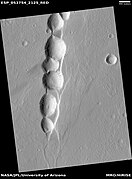
 Hollows formed by erosion on floor of crater, as seen by HiRISE under HiWish program
 -
 Esker, as seen by HiRISE under the HiWish program.
 -
 Layers, as seen by HiRISE under HiWish program Location is Tempe Terra in Arcadia quadrangle.
 -
 Layers, as seen by HiRISE under HiWish program Location is Tempe Terra Note: this is an enlargement of the previous image.


Interactive Mars map

See also
- Climate on Mars
- Glaciers
- Glaciers on Mars
- Martian Gullies
- Water on Mars
References
- ^ a b Gazetteer of Planetary Nomenclature. http://planetarynames.wr.usgs.gov Archived 2016-03-31 at the Wayback Machine.
- ^ Neesemann, A.; van Gasselt, S; Hauber, E; Neukum, G. (2010) Insights to the Evolution of the Tempe Terra Region, Mars: Refinements of Geologic and Tectonic Units. 41st Lunar and Planetary Science Conference; LPI:Houston, TX, Abstract #2685. "Archived copy" (PDF). Archived (PDF) from the original on 2011-06-29. Retrieved 2011-02-19.
{{cite web}}: CS1 maint: archived copy as title (link). - ^ Frey, H.V.; Grant, T.D. 1990. Resurfacing History of Tempe Terra and Surroundings. J. Geophys. Res., 95(B9), 14,249–14,263.
- from the original on 2012-10-02.
- ^ Malin, M., Edgett, K. 2000. Evidence for recent groundwater seepage and surface runoff on Mars. Science 288, 2330–2335.
- ^ Head, J., J. Mustard. 2006. Breccia dikes and crater-related faults in impact craters on Mars: Erosion and exposure on the floor of a crater 75 km in diameter at the dichotomy boundary, Meteorit. Planet Science: 41, 1675-1690.
- ^ Moore, J., D. Wilhelms. 2001. Hellas as a possible site of ancient ice-covered lakes on Mars. Icarus: 154, 258-276.
- ^ "Mars Art Gallery Martian Feature Name Nomenclature". www.marsartgallery.com. Archived from the original on 24 July 2016. Retrieved 7 May 2018.
- ^ Skinner, J., L. Skinner, and J. Kargel. 2007. Re-assessment of Hydrovolcanism-based Resurfacing within the Galaxias Fossae Region of Mars. Lunar and Planetary Science XXXVIII (2007)
- ^ Wyrick, D., D. Ferrill, D. Sims, and S. Colton. 2003. Distribution, Morphology and Structural Associations of Martian Pit Crater Chains. Lunar and Planetary Science XXXIV (2003)