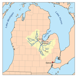
Tittabawassee River
| Tittabawassee River | |
|---|---|
 Looking north from M-61 in Hay Township | |
 Saginaw River watershed | |
| Physical characteristics | |
| Source | |
| • location | Edwards Township, Ogemaw County, Michigan |
| • coordinates | 44°05′27″N 84°18′49″W / 44.09085°N 84.31361°W[1] |
| Mouth | |
• location | Saginaw River, Michigan |
• coordinates | 43°23′12″N 83°57′58″W / 43.38669°N 83.96608°W |
| Length | 72 mi (116 km) |
| Basin size | 2,471 sq mi (6,400 km2) |
| Discharge | |
| • location | mouth |
| • average | 2,055.61 cu ft/s (58.208 m3/s) (estimate)[2] |
The Tittabawassee River (
Significant communities on or near the Tittabawassee River include Saginaw, Midland, and Sanford. At Edenville, the river was impounded by the hydroelectric Edenville Dam to create Wixom Lake. It was also impounded by a hydroelectric dam in Sanford to create Sanford Lake prior to the dam failures and resulting flooding on May 19, 2020. In Saginaw County, the river flows through Tittabawassee Township, which is named for the river and contains the unincorporated community of Freeland.
The main river is 72.4 miles (116.5 km) long[3] and drains an area of 2,471 square miles (6,400 km2).[4]
Floods
On May 19, 2020, the Edenville Dam failed, followed by the Sanford Dam downstream being overtopped and a dike breaking at Poseyville, resulting in major flooding in Midland County.
-
three-way footbridgeat the confluence of the Tittabawassee and Chippewa rivers
-
May 2020 floods viewed from space.
See also
References
- ^ "Tittabawassee River". Geographic Names Information System. United States Geological Survey, United States Department of the Interior.
- ^ United States Environmental Protection Agency. "Watershed Report: Tittabawassee River". WATERS GeoViewer. Archived from the original on July 5, 2021. Retrieved July 5, 2021.
- ^ a b United States Geological Survey. "National Hydrography Dataset high-resolution flowline data". The National Map. Retrieved November 7, 2011.
- ^ "Tittabawassee River Assessment" (PDF). Michigan Department of Natural Resources.
- ^ Bryan, Whitney (May 19, 2020). "Residents told to evacuate immediately due to Edenville Dam failure, Sanford Dam expected failure". Saginaw, Michigan: WNEM-TV. Retrieved May 20, 2020.
- ^ "Thousands evacuated as river dams break in central Michigan". Detroit Free Press. Associated Press. Retrieved May 20, 2020.
- ^ Jordan, Heather (May 20, 2020). "More Midland County residents ordered to evacuate after dike on Poseyville breaks". MLive. Retrieved May 20, 2020.
- ^ LeBlanc, Beth (May 20, 2020). "Whitmer seeks FEMA aid for Midland's widespread flooding". The Detroit News. Retrieved May 20, 2020.
- ^ Hunter, George & Donnelly, Francis X. (May 20, 2020). "Flood evacuees wait to learn extent of damage to homes". The Detroit News. Retrieved May 20, 2020.
- ^ Matheny, Keith (May 20, 2020). "Dow Chemical in Midland: Flood water mixed with our containment ponds". Detroit Free Press. Retrieved May 20, 2020.
- ^ Schafer, Ashely (May 19, 2020). "Sanford Dam failure imminent; Midland residents evacuating". Midland Daily News. Retrieved May 20, 2020.


