
Torreón de San Lázaro
| El Torreón de San Lázaro | |
|---|---|
 | |
 | |
| General information | |
| Type | Defense |
| Town or city | Havana |
| Country | Cuba |
| Coordinates | 23°08′30″N 82°22′27″W / 23.141605482397°N 82.37408954425452°W |
| Opened | 1781 |
| Height | 9.14 metres |
| Dimensions | |
| Diameter | 4.57 metres |
| Technical details | |
| Structural system | Load bearing |
| Material | Masonry |
| Floor count | 1 |
El Torreón de San Lázaro is
World Heritage List, because of the city's importance in the European conquest of the New World and its unique architecture.[2]
History


From this fortification a lookout could warn military forces by way of torches of threats of attack by
pirates. In this regard, it served as a link in the defense chain between the Batería de la Reina, La Punta, and the Santa Clara Battery located at the site of today's Hotel Nacional.[3]
Gallery
-
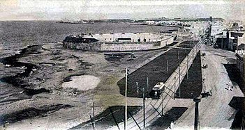 Batería de la de la Reina
 -
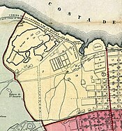 Map of Habana 1866
 -
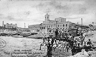 Hospital de San Lázaro, founded in 1781, showing Caleta de San Lazaro


See also
References
- ^ "Torreón de San Lázaro…! Qué vienen los ingleses!". 6 December 2020. Retrieved 2021-11-08.
- ^ "Old Havana and its Fortification System". UNESCO World Heritage Centre. United Nations Educational, Scientific, and Cultural Organization. Retrieved 26 May 2021.
- ^ "Forts of Cuba". Retrieved 2021-11-08.
Wikimedia Commons has media related to Torreón de San Lázaro.