Tule Valley
| Tule Valley | |
|---|---|
| 1859: White Valley | |
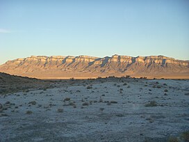
 Shadow on the eponymic white rocks of the Tule Valley, November 2009 | |
| Floor elevation | 4,780 ft (1,460 m) |
| Area | 248 sq mi (640 km2) |
| Geography | |
| Coordinates | 38°57′25″N 113°22′34″W / 38.9568985°N 113.376079°W |
Tule Valley (also known as White Valley) is a valley in Millard County, Utah, United States.[1]
Description
The valley is a north-south trending
Middle Range and the Great Salt Lake Desert, and the south by Wah Wah Valley and the Wah Wah Mountains. The central part of the valley has several knolls, the largest of which is Coyote Knolls. The White Valley name comes from the abundance of white rocks noted by James H. Simpson in 1859.[3] These rocks are mostly Lake Bonneville marls
in the valley floor.
Geographic features

Tule Valley's most prominent feature may be Coyote Springs, an important spring system for local wildlife and
Tule" is a reference to a swamp plant that probably was found at Coyote Springs during the early exploration of the valley.[3]
The valley itself is very isolated and only has one paved road through its southern end,
playa, the place where all precipitation from the drainage basin collects, since it is an isolated basin and watershed.[4] This is the location of the lowest point in Millard County, Utah.[5]
The Ibex Crags offer "world class" bouldering to climbers. They are located on the eastern edge of the Great Basin.[6]
Geology
The geology of Tule Valley consists of
normal faults on both sides of the valley. The knolls in the valley are horsts of Silurian to Devonian carbonates.[7]
Tule Valley watershed
The Tule Valley
See also
References
- ^ U.S. Geological Survey Geographic Names Information System: Tule Valley
- ISBN 978-0-7627-2566-3
- ^ ISBN 0-87480-345-4
- ^ "Surf Your Watershed". EPA.
- ISBN 978-0-87480-932-9.
- ^ "Ibex Crags". BLM.
- ISBN 0-87842-228-5.
- ^ Davis, Fitzhugh D (2005). "Water Resources of Millard County, Utah" (PDF). Utah Geological Survey. p. 12. Retrieved 2010-05-09.
- ^ "West Desert Basin" (PDF). Utah State Water Plan. Retrieved 2010-05-06.
External links
![]() Media related to Tule Valley at Wikimedia Commons
Media related to Tule Valley at Wikimedia Commons


