
Upper Camster
| Upper Camster | |
|---|---|
 Upper Camster Location within the Caithness area | |
| OS grid reference | ND262414 |
| Council area | |
| Country | Scotland |
| Sovereign state | United Kingdom |
| Postcode district | KW3 6 |
| Police | Scotland |
| Fire | Scottish |
| Ambulance | Scottish |
Upper Camster is a small hamlet, which lies at the source of the
Highland.[1]
The Grey Cairns of Camster are two large Neolithic chambered cairns located about quarter of a mile north of Upper Camster. The cairns, which are considered to be examples of the Orkney-Cromarty type of chambered cairn, were constructed in the third or fourth millennium BC in a desolate stretch of boggy peat-covered moorland in the Flow Country of Caithness.[2]
Gallery
-
 Camster Long Cairn, Upper Camster
 -
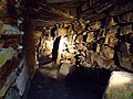 Burial chamber inside Camster Long.
 -
 Camster Cairns.
 -
 The Grey Cairns of Camster. These cairns are open to the public.
 -
 Grey Cairns of Camster, Caithness, Scotland - Camster Long Cairn, exterior
 -
 Remote road in the flow country


References
- ^ Microsoft; Nokia. "Upper Camster" (Map). Bing Maps. Microsoft. Retrieved 4 January 2018.
- ^ "Grey Cairns of Camster". Historic Environment Scotland. Retrieved 4 January 2018.
This Highland location article is a stub. You can help Wikipedia by expanding it. |