
Upper Galilee
Upper Galilee
| |
|---|---|
| Highest elevation | 1,208 m (3,963 ft)) |
The Upper Galilee (
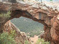
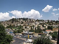
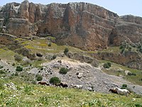
The Upper Galilee is known for its natural beauty, including lush landscapes, Mediterranean forests, and scenic vistas. Significant natural sites include Nahal Amud and the Keshet Cave. It's also an area where vineyards and wineries thrive, producing quality wines. Mount Meron stands as the highest point in the area, reaching an elevation of 1,208 meters above sea level. Safed is a main city in the region.
Several historical definitions have expanded the Upper Galilee's boundaries to encompass portions of southern Lebanon as well.
Boundaries
Originally, the term "Upper Galilee" referred to a larger region, encompassing the mountainous regions of what is today northern Israel and southern Lebanon. The boundaries of this region were the Litani River in the north, the Mediterranean Sea in the west, the Lower Galilee in the south (from which it is separated by the Beit HaKerem Valley), and the upper Jordan River and the Hula Valley in the east.[1]
According to the first century Jewish historian
In present-day usage, the
History
Ancient times
The Upper Galilee is home to numerous significant
Modern period
This section needs additional citations for verification. (January 2022) |

Following the dissolution of the
However, only less than half this area was actually included in British Mandatory Palestine, the final border being influenced both by diplomatic maneuverings and struggles between Britain and France and by fighting on the ground, especially the March 1920 battle of Tel Hai.
For a considerable time after the border was defined so to make the northern portion of the territory concerned part of the French mandated territory that became Lebanon, many Zionist geographers — and Israeli geographers in the state's early years — continued to speak of "The Upper Galilee" as being "the northern sub-area of the Galilee region of Israel and Lebanon".
Under this definition, "The Upper Galilee" covers an area spreading over 1,500 km2, about 700 in Israel and the rest in Lebanon. This included the highland region of
is one of the major cities in this region".In recent decades, however, this usage has virtually disappeared from the general Israeli discourse, the term "Upper Galilee" being used solely in reference to the part located in Israel.

Gallery
-
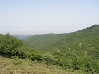 Mountainous area in the Upper Galilee
 -
 Ain Ebel in the Lebanese Upper Galilee
 -
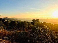
 A view looking north from the top ofHar Meronin the Upper Galilee. Parts of southern Lebanon are visible in the background
 -
 Old road from Rosh Pinna to Safed, Upper Galilee, Israel
 -
-
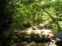 TheAmud river
 -
-

-
 Horses roam in Amud stream, near the Sea of Galilee


See also
References
- ^ a b Vilnai, Ze'ev (1976). "Upper Galilee". Ariel Encyclopedia (in Hebrew). Vol. 2. Israel: Am Oved. pp. 1364–67.
- Wars of the Jews) II, 577; III, 46 (Wars of the Jews 3.3.1)
- ^ Eric M. Meyers, "Galilean Regionalism as a Factor in Historical Reconstruction," in: Bulletin of the American Schools of Oriental Research (No. 221, 1976), p. 95
- ISBN 978-90-04-29417-2, retrieved 2023-09-02
- ^ Eric M. Meyers and Carol Meyers, "Excavations at Ancient Nabratein: Synagogue and Environs," Meiron Excavation Project Reports - MEPR 6, Eisenbrauns, 2009.
- ISBN 978-90-04-25772-6. Retrieved 8 April 2020.
- ^ Remains of Roman Period Synagogue Discovered in Galilee, July 2, 2012, Science News
- ISBN 978-0-8264-8571-7. Retrieved 15 May 2011.
- )
- ISSN 0333-5844.
- ISBN 978-3-11-071577-4, retrieved 2024-02-23
- ISBN 1-85043-091-8.