User:Ruedi33a
Use lists instead:
- List of works by Caravaggio
- List of works by Vincent van Gogh
- List of works by August Macke
- List of works by Franz Marc
- List of artworks by Marc Chagall
- List of paintings by Paul Cézanne
- List of paintings by Georges Seurat
- List of paintings by Paul Signac
- List of paintings by Camille Pissarro
- List of sculptures by Auguste Rodin
- List of sculptures by Camille Claudel
- List of sculptures by Henry Moore
- List of paintings by Wassily Kandinsky
- List of works by Francisco Goya
Use Sequence in addition:
| Preceded by Invasion of Portugal (1807) |
Napoleonic Wars Dos de Mayo Uprising |
Succeeded by Battles of El Bruch |
Avoid
Avoid subsections like
Not used in the mobile TOC
In mobile view, all articles have no TOC by default. Instead, the sections are collapsible. But the subsections are not visible and by that you cannot jump to a subsection. Big lists like List of works by Francisco Goya were not readable in a proper way till the subsections were migrated to sections.
- WP:OR
- WP:PUFF
- Anything with px because of MOS:IMGSIZE
Use visible templates
I suggest to use these templates especially as they are visible for mobile users:
Key:
1
Third Coalition: Germany 1803:...Austerlitz...2
Fourth Coalition: Prussia 1806:...Jena...3
Peninsular War: Portugal 1807...Torres Vedras...4
Peninsular War: Spain 1808...Vitoria...5
Fifth Coalition: Austria 1809:...Wagram...6
French invasion of Russia 1812:...Moscow...7
Sixth Coalition: Germany 1813:...Leipzig...8
Sixth Coalition: France 1814:...Paris...9
Hundred Days 1815:...Waterloo...| Basilica di Santa Maria in Montesanto | |
|---|---|
 | |
 Click on the map for a fullscreen view. | |
| 41°54′36″N 12°28′37″E / 41.909911°N 12.476928°E | |
| Location | Piazza del Popolo |
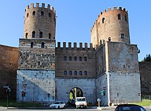
 Porta San Sebastiano | |
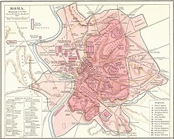
 Click on the map for a fullscreen view | |
| Location | Rome |
|---|---|
| Coordinates | 41°52′25″N 12°30′07″E / 41.87361°N 12.50194°E |
Attrition warfare against Napoleon | |||||||||||||||||||||||||||||||||||||||||||||||||||||||||||||||||||||||||||||||||||||||||||||||||||||||||||||||||||||||||||||||||||||||||||||||||||||||||||||||||||||||||||||||
|---|---|---|---|---|---|---|---|---|---|---|---|---|---|---|---|---|---|---|---|---|---|---|---|---|---|---|---|---|---|---|---|---|---|---|---|---|---|---|---|---|---|---|---|---|---|---|---|---|---|---|---|---|---|---|---|---|---|---|---|---|---|---|---|---|---|---|---|---|---|---|---|---|---|---|---|---|---|---|---|---|---|---|---|---|---|---|---|---|---|---|---|---|---|---|---|---|---|---|---|---|---|---|---|---|---|---|---|---|---|---|---|---|---|---|---|---|---|---|---|---|---|---|---|---|---|---|---|---|---|---|---|---|---|---|---|---|---|---|---|---|---|---|---|---|---|---|---|---|---|---|---|---|---|---|---|---|---|---|---|---|---|---|---|---|---|---|---|---|---|---|---|---|---|---|---|
| |||||||||||||||||||||||||||||||||||||||||||||||||||||||||||||||||||||||||||||||||||||||||||||||||||||||||||||||||||||||||||||||||||||||||||||||||||||||||||||||||||||||||||||||
km: rounded distance to Kowno, the start of the war | |||||||||||||||||||||||||||||||||||||||||||||||||||||||||||||||||||||||||||||||||||||||||||||||||||||||||||||||||||||||||||||||||||||||||||||||||||||||||||||||||||||||||||||||
| Today's location of the battle, its name and date |
French leader | Coalition leader |
|---|---|---|
Siege of Toulon 1793-08-29 1793-12-19 |
Victory: Carteaux Dugommier Napoleon Poype Charlot |
Defeat: |
| |||||
 Main façade | |||||
| Location | Venice, Italy | ||||
|---|---|---|---|---|---|
| Denomination | Roman Catholic | ||||
| Consecrated | 8 October 1094 | ||||
| Titular saint | Mark the Evangelist | ||||
| History | |||||
| |||||
| Designation | Cathedral (minor basilica) 1807–present | ||||
| Episcopal see | Patriarchate of Venice | ||||
| |||||
| Designation | Ducal chapel c. 836–1797 | ||||
| Tutelage | Doge of Venice | ||||
| Building details | |||||
| |||||
| |||||
| Built | c. 829–c. 836 | ||||
| Rebuilt | c. 1063–1094 | ||||
| Styles | Byzantine, Romanesque, Gothic | ||||
| |||||
| Length | 76.5 metres (251 ft) | ||||
| Width | 62.6 metres (205 ft) | ||||
| Outer height (central dome) | 43 metres (141 ft) | ||||
| Inner height (central dome) | 28.15 metres (92.4 ft) | ||||
| Map | |||||
| |||||
| French Revolutionary Wars | |||
|---|---|---|---|
| Part of the Coalition Wars | |||
 Click an image to load the appropriate article. Left to right, top to bottom: Battles of Valmy, Toulon, Fleurus, Quiberon, Arcole, Mantua, the Pyramids, the Nile, Zurich, Marengo, Hohenlinden, the Haitian Revolution | |||
| |||
| 1805 | C3 | C3 | C3 | C3 | ||||
| 1806 | C4 | C4 | C4 | |||||
| 1807 | C4 | C4 | PW | PW | PW | |||
| 1808 | PW | PW | PW | PW | PW | |||
| 1809 | C5 | C5 | PW | PW | PW | PW | ||
| 1810 | PW | PW | PW | PW | ||||
| 1811 | PW | PW | PW | PW | ||||
| 1812 | RC | RC | RC | RC | PW | PW | PW | PW |
| 1813 | C6 | C6 | C6 | C6 | PW | PW | PW | PW |
| 1814 | C6 | C6 | C6 | C6 | PW | PW | PW | PW |
| 1815 | C7 | C7 | C7 | C7 |
| XX | Under Napoleon's command |
| XX | Napoleon personally involved |
| XX | Attrition warfare against Napoleon |
| XX | Conventional Warfare against Napoleon |
| XX | Trachenberg Plan against Napoleon |
| C3 | War of the Third Coalition |
| C4 | War of the Fourth Coalition |
| C5 | War of the Fifth Coalition |
| C6 | War of the Sixth Coalition |
| C7 | War of the Seventh Coalition
|
| PW | Peninsular War |
| RC | Russian Campaign |
Add sister projects
 Rome/Old Rome travel guide from Wikivoyage
 Media related to Battle of Austerlitz at Wikimedia Commons:Category
 Media related to Battle of Austerlitz at Wikimedia Commons:Gallery
 The dictionary definition of bérézina at Wiktionary
 Works related to Treaty of Amiens at Wikisource
- wikidata:Q19882428


