Vendenheim
You can help expand this article with text translated from the corresponding article in French. (December 2008) Click [show] for important translation instructions.
|
Vendenheim | |
|---|---|
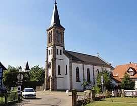
 The church in Vendenheim | |
Strasbourg Eurométropole | |
| Government | |
| • Mayor (2020–2026) | Philippe Pfrimmer[1] |
| Area 1 | 15.89 km2 (6.14 sq mi) |
| Population (2021)[2] | 6,042 |
| • Density | 380/km2 (980/sq mi) |
| Time zone | UTC+01:00 (CET) |
| • Summer (DST) | UTC+02:00 (CEST) |
| INSEE/Postal code | /67550 |
| Elevation | 131–181 m (430–594 ft) (avg. 150 m or 490 ft) |
| 1 French Land Register data, which excludes lakes, ponds, glaciers > 1 km2 (0.386 sq mi or 247 acres) and river estuaries. | |
Vendenheim (French pronunciation:
Population
| Year | Pop. | ±% p.a. |
|---|---|---|
| 1968 | 2,772 | — |
| 1975 | 3,457 | +3.21% |
| 1982 | 3,520 | +0.26% |
| 1990 | 5,193 | +4.98% |
| 1999 | 5,597 | +0.84% |
| 2007 | 5,646 | +0.11% |
| 2012 | 5,548 | −0.35% |
| 2017 | 5,664 | +0.41% |
| Source: INSEE[6] | ||
See also
References
- ^ "Répertoire national des élus: les maires". data.gouv.fr, Plateforme ouverte des données publiques françaises (in French). 2 December 2020.
- ^ "Populations légales 2021". The National Institute of Statistics and Economic Studies. 28 December 2023.
- ^ "Localisation et prononciation des noms de lieux d'Alsace commençant par T, U, V, W ou Z". elsasser.free.fr. Archived from the original on 2020-09-13. Retrieved 2019-03-17.;
- ^ INSEE commune file
- ^ Barrow, Keith (4 July 2016). "Commercial operations begin on TGV Est Phase 2". International Rail Journal. Retrieved 13 January 2021.
- ^ Population en historique depuis 1968, INSEE
Wikimedia Commons has media related to Vendenheim.


