
Sélestat
Sélestat | |
|---|---|
Subprefecture and commune | |
 The Clock Tower | |
.svg) Coat of arms | |
Location of Sélestat  | |
 Sélestat  Sélestat | |
| Coordinates: 48°15′34″N 7°27′15″E / 48.259444°N 7.454167°E | |
| Country | France |
| Region | Grand Est |
| Department | Bas-Rhin |
| Arrondissement | Sélestat-Erstein |
| Canton | Sélestat |
| Intercommunality | CC de Sélestat |
| Government | |
| • Mayor (2020–2026) | Marcel Bauer[1] |
| Area 1 | 44.40 km2 (17.14 sq mi) |
| Population (2021)[2] | 19,300 |
| • Density | 430/km2 (1,100/sq mi) |
| Time zone | UTC+01:00 (CET) |
| • Summer (DST) | UTC+02:00 (CEST) |
| INSEE/Postal code | 67462 /67600 |
| Elevation | 165–184 m (541–604 ft) (avg. 173 m or 568 ft) |
| 1 French Land Register data, which excludes lakes, ponds, glaciers > 1 km2 (0.386 sq mi or 247 acres) and river estuaries. | |
Sélestat (French:
In 2019, Sélestat had a total population of 19,242, which makes it the eighth most populous town in Alsace. During the
Thanks to its rich heritage, which includes the renowned
Name

The present name of the town is a
Sélestat was first mentioned in 727 as Sclastat.[5] It was mentioned as Scalistati in 775, as Slectistat in 881, as Sclezistat in 884 and as Slezestat in 1095.[6] The current German name, Schlettstadt, appeared in 1310, although various spellings can be noticed on posterior documents, such as Schlestat, Schletstat and Schlettstat.[4] The French administration used various forms from the 17th to the 19th century, such as Frenchified (Sélestat, Sélestadt) and Germanic (Schlestadt, Schelestadt). The town was officially known as Schlettstadt between 1871 and 1919, when Alsace was part of the German Empire.[4] Since 1920, the town's French name is fixed as Sélestat.
The origin of the name "Schlettstadt" is unclear. It probably derives from Germanic words slade or sclade meaning "marshes", and stat for "city". Sélestat would then be a "city in the marshes", a reference to its position in the Grand Ried, a vast area subject to flooding that stretches over the centre of Alsace. Stat could also mean "area" rather than "city".[7]
A popular myth explains that the town takes its name from a
History
Birth of the town

Sélestat was first mentioned in 727 AD but the town probably has an earlier Celtic or Roman origin.[C 1] Archaeological findings provide evidence of human settlement during the Mesolithic, the Neolithic and the Bronze Age. A large number of wood piles dating from the 1st and 2nd centuries AD were discovered around St. Quirin chapel, suggesting a Roman settlement. At that time Sélestat might have already been a port on the river Ill.[B 1]
When Sélestat started to appear in written documents in the 8th century, it may have been a market town or simply a village populated by fishermen and farmers. The area was part of the estate of Eberhard, a member of the Alsatian ducal family, who donated it to Murbach Abbey at the end of his life.[C 1] In 775, Charlemagne spent Christmas in Sélestat, which indicates that the town must have had enough appropriate buildings and population to accommodate his court and troops.[C 1]
In the 1080s, Sélestat was the property of Hildegard von Eguisheim, mother of
Free imperial city
.jpg)
The
Being a free city, Sélestat attracted settlers from the region who sought protection, freedom and a thriving economic environment. The first city wall, which had become too constricting, was replaced in 1280, and a third wall had to be erected in the 16th century as the city grew.[C 2] At the end of the Middle Ages, the population was estimated at between 5,000 and 6,000.[C 2] It was then the fourth largest Alsatian town after Strasbourg (18,000), Colmar and Haguenau (6,000 each).[D 2] The local economy reached its zenith around 1500.[D 3] It was centered on shipping and trade (mainly hay, cereals, wine, fish, glass, iron and salt). As the road network was poor and dangerous, goods transited via the Ill river.[C 2]
Decline
The decline of the town started in the 1520s, when the humanist school lost its former influence. The troubles surrounding the
During the 17th century, Alsace was one of the main battlefields of the
At first, Sélestat was a major strategic stronghold for the French. Located near the
Since 1815

Industry appeared very early in Sélestat. The town had already several factories at the beginning of the 19th century: a tilery, a sawmill, 12 tanneries and 11 mills. Sélestat quickly became specialised in wire gauze making
Sélestat became French again after the
South of the town, at 48°15′4″N 7°25′28″E / 48.25111°N 7.42444°E, a large broadcasting facility was used for transmitting on 1161 kHz and 1278 kHz in the medium-wave range.[10] It was opened in 1948[11] and ceased to emit on 1 January 2016.[12]
Governance

Sélestat is one of the six
Sélestat is a member of a federation of communes with shared competencies: the Communauté de communes de Sélestat. Sélestat is its main town, and it includes 11 neighbouring villages. It was created in 1995 to replace an older but similar structure founded in 1969.[15] Sélestat is also the seat of the Central Alsace pays, a structure aiming at developing the area.[16]
The town has had a council since 1292, when it was granted a constitution under the Holy Roman Empire. The constitution shaped the local political system until the French Revolution of 1789. Since then, the town has been administered as all the other communes of France. Its council currently comprises 33 councillors, whose number is defined by law according to the size of the population. The town also has a mayor elected by the councillors.[17]
Alsace in general is a stronghold of the French right.[18] The main French right-wing party, The Republicans, currently holds a large majority in the council (26 councillors). Marcel Bauer, who has been mayor since 2001, is also a member of that party. Voters in Sélestat generally favour right-wing candidates at other elections as well, although Sélestat was governed by the Socialist Party between 1989 and 2001.[19][20]
Geography

Sélestat is located at the very centre of Alsace, near the limit separating the Bas-Rhin and Haut-Rhin departments, which traditionally correspond to Lower and Upper Alsace, respectively. The town is located between Strasbourg and Mulhouse, the first being 42 kilometres (26 mi) north and the latter 57 kilometres (35 mi) south of the city. Sélestat is also located between Obernai (22 kilometres (14 mi)) and Colmar (21 kilometres (13 mi)). On the other side of the Rhine, Freiburg im Breisgau is around 40 kilometres (25 mi) distant.
Sélestat lies on the Alsace plains, a narrow, very fertile area that stretches between the
The town itself is built on the Giessen alluvial fan so it is slightly higher than the rest of the Alsace plains. Much of its territory is however located on areas liable to flooding. Such areas are mostly located inside the Illwald natural reserve and comprise both forests and meadows. There the Ill forms more than 150 kilometres (93 mi) of waterways.[E 1]
-
 The Ill in Sélestat.
 -
 The Oberriedgraben in the Illwald.
 -
 The Schiffwasser in the Illwald.
 -
 The Giessen.


Transport


Despite its small size, Sélestat is well connected to transport networks. Alsace as a whole, being part of the economic heart of Europe, has a high road and railway density.
The town is served by the
Sélestat train station was opened in 1840, which makes it one of the oldest in France. It lies on the Strasbourg–Basel railway, which also serves Colmar, Mulhouse and Saint-Louis.[A 2] Sélestat is at the terminus of two local railways that are partly closed: Sélestat-Lesseux, now ending in Lièpvre, and Sélestat-Saverne, now ending in Molsheim. The former railway runs towards the west through the Vosges, while the latter runs towards the northwest. A third local line, Sélestat-Sundhouse, closed in 1953.[23] Although one of the oldest in France, the Strasbourg-Basel railway allows high speed travel of (200 kilometres per hour (120 mph)) because it is very rectilinear and crosses a very flat landscape. Sélestat is served by all regional trains between Strasbourg and Basel (one train in each direction every hour on weekdays).[24] Local trains also run between Sélestat and Molsheim, Sélestat and Strasbourg and Sélestat and Barr.[25][26] Sélestat is served by a Paris-Colmar TGV every day in each direction, by Strasbourg-Nice and Strasbourg-Cerbère Intercités in the summer, and by EuroCity trains connecting Zürich to Brussels and Basel to Luxembourg.
Sélestat and its communauté de communes have their own local bus network, the "Transport intercommunal de Sélestat" (TIS).[29] It comprises two lines, one connecting Châtenois to Ebersheim, and the other Scherwiller to Muttersholtz. These two lines make several stops in Sélestat proper, which is at the centre of the network.[30]
Demography
|
|
| |||||||||||||||||||||||||||||||||||||||||||||||||||||||||||||||||||||||||||||||||||||||||||||||||||||||||||||||||||||
| |||||||||||||||||||||||||||||||||||||||||||||||||||||||||||||||||||||||||||||||||||||||||||||||||||||||||||||||||||||||
| Sources: Base Cassini from EHESS for figures until 1962,[31] and INSEE for figures since 1968[32] | |||||||||||||||||||||||||||||||||||||||||||||||||||||||||||||||||||||||||||||||||||||||||||||||||||||||||||||||||||||||
As of 2019[update], Sélestat had 19,242 inhabitants.
Sélestat was one of the largest towns in the region from the
The demographic growth that occurred in Sélestat after 1945 was primarily due to a relatively high birth rate[C 9] (20.1‰ in Sélestat over the period 1968–1975, compared to 16.9‰ in France). After 1975, this rate progressively declined to match the national figure. Net migration figures remained slightly negative until 1990[35] because Sélestat and Central Alsace were on the margins of the metropolitan areas of Strasbourg and Colmar and lacked attractivity. Since 1990, the Strasbourg area greatly expanded to gradually reach Sélestat. The town has thus become more attractive to newcomers.[36]
The population of Sélestat is relatively young, 36.2% of the population were under 30 in 2017 (France: 35.7%) and the percentage of people over 60 years old (23.6%) was lower than the national (25.5%) figure.[35] Sélestat has a significant proportion of people between 15 and 44 (39.7%, compared to 36.4% for all of France) because it attracts a large number of young actives and couples starting a family. As other towns in the region, such as Saverne, Haguenau and Molsheim, it welcomes young adults and encourages them to settle in the surrounding villages.[36]
Economy

At the end of 2015, Sélestat had 2,142 businesses, most of them (1,441) in the tertiary sector. A large share were small businesses; only 9% had more than 10 employees.[35] Sélestat is a retail and services centre for the whole Central Alsace, with a large shopping park and administrative and educational institutions.[C 10] Industry is nonetheless represented by some large firms, such as the Société alsacienne de meubles, which builds kitchens and bathrooms under a Schmidt and Cuisinella franchise, Amcor (aluminium packaging), Daramic (battery separators), Albany (gauzes for the printing industry), Wanzl (warehouse material), and DHJ (textiles).[E 2]
Most of the large factories are in an industrial estate located south of the town centre. Created in the 1930s, it covers a site of 67 hectares (166 acres).[C 11][E 3] The newer commercial estate north of the town was developed in the 1970s and is dedicated to retail and cottage industry. It covers 134 hectares (331 acres).[B 4][E 3] The town centre is also an important shopping area with more than 200 businesses.[E 4]
Sights and culture
In terms of architecture the city is one of the richest and most varied among the smaller cities of Alsace. Although it is only the 8th most populous town in the region, it has the third largest cultural heritage after Strasbourg and Colmar.[37] Sélestat has 35 listed buildings and 119 additional sites that are indexed in the French list of cultural heritage monuments.[38]
Museums

The
The library is open to both researchers and tourists, with an exhibition displaying some of its most noteworthy items: an 8th-century lectionary, the first books printed in Alsace, a copy of the Cosmographiae Introductio where the oldest mention of America can be found, and a 1521 document which contains the oldest record of a Christmas tree.[40]
Sélestat also has a museum dedicated to bread and baking[41] and it is the seat of the FRAC d'Alsace, a regional institution whose aim is to collect contemporary works of art (see below, Cultural institutions and events). These works are regularly part of temporary exhibits in Sélestat and other places in Alsace. FRAC possesses works by Aurélie Nemours, Olivier Debré, Mario Merz and Panamarenko, among other artists.[42]
Religious architecture

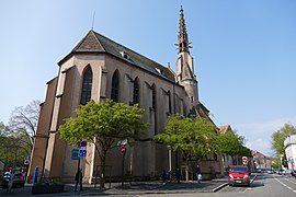
Sélestat has two large and remarkable churches from the
St. George's Church has always served as the main parish church. It is often referred to as "the cathedral" because of its size, but it has never been the seat of a diocese. Its construction started soon after 1200 and was completed at the beginning of the 15th century. Its design is pure Gothic, save for a Romanesque side portal. The choir, the last part to be completed, is the most remarkable element. It is illuminated by 288 stained glass panels, of which 55 date from the 15th century.[B 6]
Most of the convents of the town have disappeared; the
The synagogue was built in 1890. Its architecture is typical of the region, with a square shape and discreet neo-romanesque ornaments. Its cupola was destroyed in 1940 by the Nazis and never rebuilt.[B 8] The Jewish cemetery, located outside the old town, was opened in 1622. It has several 18th century gravestones showing a Christian artistic influence.[B 10]
-
 The death mask in St. Faith's.
 -
 St. George's Church.
 -
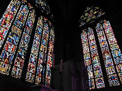 Stained-glass windows in St. George's.
 -
 The Protestant church.
 -
 The synagogue.


Civil and military architecture

The old town comprises a large number of medieval and Renaissance buildings. The quai des Tanneurs ("tanners' quay") is one of the most picturesque streets in Alsace. A stream used to flow in the middle of the street until the beginning of the 20th century, the relic of a former noxious-smelling trade, since tanning required large amounts of flowing water for treating and washing animal skins. Most of the old tanner houses date back to the Middle Ages and have a tall attic to provide a ventilated space for drying leather.[B 11] In the neighbouring streets, rue des Oies ("geese street") and rue des Veaux ("calf street"), many houses were covered with a coat of plaster in the 19th century to hide the timbering, which was considered too rustic.[B 12]
Several hôtels particuliers (large townhouses) date from the Renaissance. Most of them have oriel windows that are characteristic of German Renaissance architecture. The grandest of these hôtels belonged to the Ebersmunster abbey and it has a large three-story granary. The Ziegler house has a beautiful oriel that shows the interest of the elite of that time in Antiquity. The oriel partly reflects Vitruvius's architectural legacy and displays the portraits of four key figures of Antiquity. Baroque architecture is visible on some later hôtels dating from the 17th and 18th century. French classical architecture and its main feature, the mansard roof, were largely employed in the 18th century. To reduce costs, buildings were still built with timber framing, but as this technique was considered too Germanic and rustic, they were often covered with a rendering imitating stone.[B 13]

The German period (1871–1918) left some examples of Wilhelminism in the city's architecture. This prestige-oriented style is a mixture of various earlier styles, including Romanesque, Gothic and neoclassical. Noteworthy are the post office (1884),[B 14] the courthouse (1900),[B 15] the lycée Koeberlé (1913)[B 16] and the water tower (1906). The latter (height: 50 m (160 ft)) was largely inspired by the water tower in Deventer, Netherlands.[43]
The medieval city walls, built in several stages between the 13th and the 16th century, were torn down after the French annexation in the 17th century. However, four towers escaped destruction. The Tour des Sorcières ("witches' tower"), which served as a gate and a jail, is the tallest.[B 17] The Tour de l'Horloge ("clock tower") was also originally part of a gate. The clock and the elaborate roof were added in 1614.[B 18] Two much smaller towers can also be seen, one near the Ill river and another integrated into a later house.[B 18] All these remains date from the 13th century.[B 19]
New walls were built by
-
 Rue Koeberlé.
 -
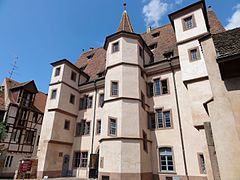 Hôtel d'Ebersmunster.
 -
 One of the many squares.
 -
 The water tower.
 -
 Tour des Sorcières.
 -
 Arsenal Ste Barbe.


Municipal archive
The municipal archive (archives municipales) of Sélestat owns and exhibits numerous ancient documents, among which royal charters dating back to the 13th century and, most famously, the register dated from 1521 containing the first written mention of the Christmas tree.[44]
Illwald forest

The Illwald forest was designated a regional nature reserve in 2013.[45][46] It covers 1,855 hectares (4,584 acres), almost half of the territory of Sélestat, and is one of the largest riparian forests in France. It lies on the Ill, which forms a complex hydrographic network there. The site is subject to flooding and it is characteristic of the Grand Ried, a flat region located between the Ill and the Rhine that serves as a natural spillway for the two rivers.[E 5]
Common trees are
The Illwald contains three chapels that were originally pilgrimage destinations. The Schnellenbuhl chapel was built by Jesuits in 1683; Our Lady of the Oaks dates back to the 15th century but it was rebuilt after a fire in 1920; Our Lady of Peace was built in 1960, and St. Anthony was founded in 1280 but rebuilt in 1930.[B 21]
Other cultural institutions and events
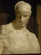
.jpg)
Sélestat is the seat of the Agence culturelle d'Alsace ("cultural agency of Alsace", ACA) since 1976.
Every year since 1927, Sélestat has organised a large flower procession through its old town. The "corso fleuri" is one of the biggest floral shows in eastern France. New floats are made each year around a theme and decorated with dahlias only.[E 7] A carnaval procession is also held in March. It is the remnant of a very old tradition started by the town's butchers.[B 22] Sélestat also has festivals dedicated to electronic music (Epidemic Experience), satirical cartoons (Sélest'ival), a spring fun fair, and a summer medieval reenactment with a market and a procession.[E 8]
The cultural complex Les Tanzmatten, built by Rudy Ricciotti, was inaugurated in 2000. It serves as the town's concert and performances hall, as well as for exhibitions, commercial fairs and weddings.[51]
Sports
Sélestat Alsace Handball is a noted French handball club. It was founded in 1967.[52] FC Sélestat, the football club, was founded in 1906.[53]
Notable people
Born in Sélestat
- Martin Bucer, German Protestant reformer
- Fabienne Keller, French politician
- Jacques Paul Klein, French-American Diplomat and General
- Eugène Koeberlé, French surgeon
- Heinrich Kramer, German inquisitor
- Johannes Mentelin, German printer
- Beatus Rhenanus, German humanist
- Charles Sitzenstuhl, French politician
- Joseph Wackenthaler, French organist and composer
- Nicolas-Joseph Wackenthaler, French organist and composer
- Jakob Wimpfeling, German humanist
Connected to Sélestat
- Ludwig Dringenberg (died in Sélestat)
- Frédéric Fiebig, painter (lived and died in Sélestat)
- Thierry Omeyer (played professionally for Sélestat)
- François Ignace Schaal (died in Sélestat)
Twin towns – sister cities
Sélestat is twinned with:[54]
 Charleroi, Belgium, since 1959
 Waldkirch, Germany, since 1966
 Grenchen, Switzerland, since 1988
 Dornbirn, Austria, since 2006
See also
References
- ^ "Répertoire national des élus: les maires". data.gouv.fr, Plateforme ouverte des données publiques françaises (in French). 2 December 2020.
- ^ "Populations légales 2021". The National Institute of Statistics and Economic Studies. 28 December 2023.
- ISBN 978-2-7165-0756-1..
- ^ ISBN 978-2-9517657-5-7.
- ^ ISBN 978-2-7165-0756-1..
- ISBN 978-2-600-00133-5.
- ISBN 2-85023-076-6.
- ^ Eglise paroissiale de la Vierge, de Saint-Georges.
- ^ "Dossier de presse, 7 siècles de vie juive à Sélestat : traces et mémoire" (PDF). Bibliothèque humaniste. 2007. Archived from the original (PDF) on 17 October 2011. Retrieved 22 May 2014..
- ^ "Sélestat Mediumwave Transmitter". Emporis. Archived from the original on August 11, 2016. Retrieved 31 July 2015.
- ^ "Sur les bonnes ondes durant 57 ans". Les Dernières Nouvelles d'Alsace. dna.fr. Retrieved 26 June 2016.
- ^ "Strasbourg – Sélestat (67)". tvignaud.pagesperso-orange.fr. Retrieved 26 June 2016.
- ^ "Décret n° 2014-185 du 18 février 2014 portant délimitation des cantons dans le département du Bas-Rhin". Légifrance. Retrieved 30 April 2014..
- ^ "Élections législatives de 2012 à Sélestat". French Ministry of the Interior. Retrieved 30 April 2014..
- ^ "Historique". Communauté de communes de Sélestat. Retrieved 30 April 2014..
- ^ "Présentation de l'Alsace Centrale". Alsace centrale. Archived from the original on 7 May 2014. Retrieved 7 May 2014..
- ^ Art L. 2121-2 du code général des collectivités territoriales.
- ^ Descamps, Élise (22 March 2010). "En votant à droite, l'Alsace cultive sa singularité politique". La Croix. la-croix.com. Retrieved 8 June 2016.
- ^ "Décès de Pierre Giersch, ancien maire de Sélestat (1996 à 2001)". France 3 Alsace. france3-regions.francetvinfo.fr. 2 June 2016. Retrieved 8 June 2016.
- ^ "Mort de Gilbert Estève, maire socialiste de Sélestat". liberation.fr. Retrieved 8 June 2016.
- ^ "Le bassin versant du Giessen et de la Lièpvrette" (PDF). Conseil général du Bas-Rhin. Archived from the original (PDF) on 20 May 2014. Retrieved 28 April 2014..
- ^ "Par la route". selestat-haut-koenigsbourg.com. Retrieved 8 June 2016.
- ^ Gare à Sundhouse.
- ^ "Strasbourg Mulhouse Bâle" (PDF). TER Alsace. Retrieved 29 April 2014..
- ^ a b "Strasbourg Sélestat Colmar" (PDF). TER Alsace. Retrieved 29 April 2014..
- ^ "Strasbourg Obernai Sélestat" (PDF). TER Alsace. Retrieved 29 April 2014..
- ^ "Sainte-Marie-aux-Mines Saint-Dié-des-Vosges" (PDF). TER Alsace. Retrieved 29 April 2014..
- ^ "Plan Alsace centrale" (PDF). Conseil général du Bas-Rhin. Archived from the original (PDF) on 20 May 2014. Retrieved 29 April 2014..
- ^ "Transport intercommunal de Sélestat". TIS – Transport intercommunal de Sélestat. tis-selestat.com. Retrieved 8 June 2016.
- ^ "Plan du réseau" (PDF). Transport urbain intercommunal. Archived from the original (PDF) on 20 May 2014. Retrieved 29 April 2014..
- ^ Des villages de Cassini aux communes d'aujourd'hui: Commune data sheet Sélestat, EHESS (in French).
- ^ Population en historique depuis 1968, INSEE, retrieved 22 July 2022
- ^ Téléchargement du fichier d'ensemble des populations légales en 2019, INSEE
- ^ "Registres paroissiaux et documents d'état civil de Sélestat". Archives départementales du Bas-Rhin. archives.bas-rhin.fr. Retrieved 8 June 2016.
- ^ a b c Dossier complet, Commune de Sélestat (67462), INSEE
- ^ a b "30 ans d'urbanisation en Alsace, Zoom sur le territoire du Scot de Sélestat et sa région" (PDF). Direction régionale de l'environnement, de l'aménagement et du logement. Retrieved 29 April 2014..
- ^ Ville.
- ^ Base Mérimée: Search for heritage in the commune, Ministère français de la Culture. (in French)
- ^ "Beatus Rhenanus Library". unesco.org. Retrieved 8 June 2016.
- ^ "Bibliothèque Humaniste". Musées d'Alsace. Retrieved 31 May 2014..
- ^ "Maison du Pain d'Alsace". Musées d'Alsace. Archived from the original on 2 June 2014. Retrieved 31 May 2014..
- ^ "La collection du Frac Alsace". Agence culturelle d'Alsace. Retrieved 31 May 2014..
- ^ "Château d'eau". selestat.fr. Retrieved 9 June 2016.
- ^ "Fonds des Archives municipales". selestat.fr. Retrieved 5 January 2017.
- ^ "Ried de l'Ill*Wald" (in French). Réserves Naturelles de France. Retrieved 11 September 2019.
- ^ "L'Ill*Wald, Réserve Naturelle Régionale du Ried de Sélestat". Région Alsace. Archived from the original on 6 June 2014. Retrieved 3 June 2014.
- ^ "La forêt de l'Illwald". alsace.lpo.fr. Retrieved 8 June 2016.
- ^ "Historique de l'Agence culturelle d'Alsace". culture-alsace.org. Retrieved 9 June 2016.
- ^ "Missions du Frac Alsace". culture-alsace.org. Retrieved 9 June 2016.
- ^ "Archéologie Alsace – Présentation". archeologie.alsace. Archived from the original on 20 December 2016. Retrieved 12 December 2016.
- ^ "Les Tanzmatten en bref". Site officiel des Tanzmatten de Sélestat. tanzmatten.fr. Retrieved 9 June 2016.
- ^ "Sélestat Alsace Handball : l'histoire". SAHB – Sélestat Alsace Handball. sa-hb.com. Retrieved 8 June 2016.
- ^ "Histoire et Palmarès". Football Club Sélestat. fcselestat.fr. Retrieved 8 June 2016.
- ^ "Jumelages". selestat.fr (in French). Sélestat. Retrieved 2019-11-18.
Citations
A
- ^ Dorlan 2002, p. XIV.
- ^ Dorlan 2002, p. 514.
- ^ Almira & Billoin 2000, p. 13
B
- ^ Almira & Billoin 2000, p. 23.
- ^ Almira & Billoin 2000, p. 63.
- ^ a b Almira & Billoin 2000, p. 67.
- ^ a b Almira & Billoin 2000, p. 69.
- ^ Almira & Billoin 2000, p. 91.
- ^ Almira & Billoin 2000, p. 81.
- ^ a b Almira & Billoin 2000, p. 92.
- ^ a b c Almira & Billoin 2000, p. 100.
- ^ Almira & Billoin 2000, p. 84.
- ^ Almira & Billoin 2000, p. 112.
- ^ Almira & Billoin 2000, p. 93.
- ^ a b Almira & Billoin 2000, p. 95.
- ^ Almira & Billoin 2000, p. 103.
- ^ Almira & Billoin 2000, p. 107.
- ^ Almira & Billoin 2000, p. 111.
- ^ Almira & Billoin 2000, p. 86.
- ^ Almira & Billoin 2000, p. 96.
- ^ a b Almira & Billoin 2000, p. 99.
- ^ a b Almira & Billoin 2000, p. 98.
- ^ Almira & Billoin 2000, p. 87.
- ^ Almira & Billoin 2000, p. 108.
- ^ Almira & Billoin 2000, p. 130.
C
- ^ a b c d e Encyclopédie de l'Alsace 1985, p. 6846.
- ^ a b c d e f g h Encyclopédie de l'Alsace 1985, p. 6847.
- ^ a b c Encyclopédie de l'Alsace 1985, p. 6848.
- ^ a b Encyclopédie de l'Alsace 1985, p. 6849.
- ^ a b c Encyclopédie de l'Alsace 1985, p. 6850.
- ^ a b c d Encyclopédie de l'Alsace 1985, p. 6851.
- ^ a b Encyclopédie de l'Alsace 1985, p. 6852.
- ^ Encyclopédie de l'Alsace 1985, p. 6828.
- ^ a b c Encyclopédie de l'Alsace 1985, p. 6829.
- ^ Encyclopédie de l'Alsace 1985, p. 6830.
- ^ Encyclopédie de l'Alsace 1985, p. 6839.
- ^ Encyclopédie de l'Alsace 1985, p. 6845.
- ^ Encyclopédie de l'Alsace 1985, p. 6843.
D
- ^ Vogler 2009, p. 194.
- ^ Vogler 2009, p. 181.
- ^ Vogler 2009, p. 183.
- ^ Vogler 2009, p. 195.
- ^ Vogler 2009, p. 205.
- ^ Vogler 2009, p. 198.
- ^ Vogler 2009, p. 207.
- ^ Vogler 2009, p. 209.
E
- ^ "La gestion du réseau hydrographique". Retrieved 28 April 2014..
- ^ "L'activité économique". Retrieved 8 May 2014..
- ^ a b "Zones d'activités". Retrieved 13 May 2014..
- ^ "Centre ville". Retrieved 8 May 2014..
- ^ "Au rythme de l'eau". Retrieved 28 April 2014.
- ^ "La biennale de Sélestat : plus de 20 ans d'existence". Retrieved 9 May 2014..
- ^ "Le Corso fleuri". Retrieved 9 May 2014..
- ^ "Le Sélestadien" (PDF). Retrieved 10 May 2014..
Works cited
- Dorlan, Alexandre (2002). Histoire architecturale et anecdotique de Sélestat (Schlestadt) : les transformations d'une place forte alsacienne des origines à nos jours. Vol. 1. Le Livre d'histoire. ISBN 2-84373-270-0.
- ISBN 2-7165-0526-8.
- Encyclopédie de l'Alsace. Vol. 11. Publitotal. 1985.
- Vogler, Bernard (2009). La Décapole. La Nuée bleue. ISBN 978-2-7165-0728-8.
- "City of Sélestat".
External links
- City council website (in French)
- Sélestat tourist office Archived 2010-01-29 at the Wayback Machine (in French, English, and German)
- History of the Jewish community of Sélestat (in French)
| Founding cities |  | |
|---|---|---|
| Other cities |
| |
| International | |
|---|---|
| National | |
| Geographic | |