
Venezuelan Andes
| Venezuelan Andes | |
|---|---|
| Andes venezolanos | |
.jpg) A view of Collado of Condor Peak in Venezuelan Andes | |
| Highest point | |
| Coordinates | 8°45′N 70°55′W / 8.750°N 70.917°W |
| Geography | |
 Geographic map of the Andean Venezuelan natural region.
| |
| Location | Táchira, Mérida and Trujillo states, the southern area of Lara, and portions of higher areas on the western side of Barinas, Apure, Portuguesa and Zulia states |
| Parent range | Andes |
| Geology | |
| Age of rock | Eocene |
| Type of rock | Igneous and metamorphic rocks |
The Venezuelan Andes (Spanish: Andes Venezolanos) also simply known as the Andes (Spanish: Los Andes) in Venezuela, are a
The Venezuelan Andean system represents the terminal bifurcation of the
Geography
Venezuelan Andes can be divided in two sections:
- Cordillera de Mérida: covering almost all the territory of Táchira, Mérida and Trujillo states, the southern area of Lara, and portions of higher areas on the western side of Barinas, Apure and Portuguesa states. It can be divided in three subregions:
- Western Venezuelan Andes (Macizo del Tamá, Páramos Batallón y La Negra).
- Central Venezuelan Andes (Macizo del Sur, Sierra Nevada de Mérida, Sierra de la Culata, Sierra de Santo Domingo[3]).
- North-Eastern Venezuelan Andes (Sierra de Trujillo, Sierra de Portuguesa, Lara Andes)
- .
Geology
They have a common geological origin, which dates back to the
) that began their orographic rise.Before the rise of the current Venezuelan Andes, between the
Quaternary tectonics
It's characterized by the interaction of the three most important lithospheric plates in the region:
During the
Glacial geology
Like all tropical mountain ranges with altitudes above 3,000 m, the Venezuelan Andes were affected by Pleistocene glaciations.
Late Pleistocene glaciation
Two morainic complexes have been recognized in the
In the
Late Holocene glaciation
Evidence of Late Holocene morainic sedimentation are based on palynological and radiocarbon analyses, which established a cold phase between the 15th and middle-19th centuries, which can be correlate with the Little Ice Age. The moraines associated with this phase are most probably those located at an altitude of approximately 4,700 m between 100 and 200 below the terminal zone of present-day glaciers.[11]
Gallery
-
 Los Cedros Lagoon, Trujillo State
 -
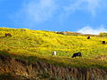 Fauna of the Venezuelan Andes
 -
 Humboldt Peak
 -
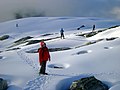 Snow in the Humboldt Peak
 -
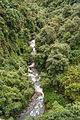 Butare River
.jpg)


See also
References
- ISBN 978-980-6838-57-4.
- ^ Pérez et al (Sep. 2005): "Alturas del Pico Bolívar y otras cimas andinas venezolanas a partir de observaciones Gps." INCI v.30, n.4, Caracas sep. 2005. Retrieved 2012-09-27. (in Spanish)
- ^ Sanchez Davila, Gabriel. "Sierra de Santo Domingo: Biogeographic reconstructions for the Quaternary of a former snowy mountain range". Academia (in Spanish). Retrieved 5 July 2019.
- ISBN 978-980-6010-67-3.
- ISBN 978-980-221-707-6.
- ^ Schubert, Carlos (1998). "Glaciers of Venezuela". US Geological Survey (USGS P 1386-I).
- S2CID 129027718.
- doi:10.1016/j.geomorph.2007.08.002.)
{{cite journal}}: CS1 maint: multiple names: authors list (link - ^ Maximiliano, B.; Orlando, G.; Juan, C.; Ciro, S. "Glacial Quaternary geology of las Gonzales basin, páramo los conejos, Venezuelan andes".
- JSTOR 25641752.
- . Retrieved 14 February 2017.
.png)