
Verneuil-sur-Avre
This article needs additional citations for verification. (December 2009) |
Verneuil-sur-Avre | |
|---|---|
Part of Verneuil d'Avre et d'Iton | |
 Tower of the Church of the Madeleine | |
.svg) Coat of arms | |
Location of Verneuil-sur-Avre  | |
Verneuil-sur-Avre | |
| Commune | Verneuil d'Avre et d'Iton |
| Area 1 | 31.97 km2 (12.34 sq mi) |
| Population (2019)[1] | 6,401 |
| • Density | 200/km2 (520/sq mi) |
| Time zone | UTC+01:00 (CET) |
| • Summer (DST) | UTC+02:00 (CEST) |
| Postal code | 27130 |
| Elevation | 147–193 m (482–633 ft) |
| 1 French Land Register data, which excludes lakes, ponds, glaciers > 1 km2 (0.386 sq mi or 247 acres) and river estuaries. | |
Verneuil-sur-Avre (French pronunciation: [vɛʁnœj syʁ avʁ], literally Verneuil on Avre) is a former commune in the Eure department in Normandy in northern France. On 1 January 2017, it was merged into the new commune Verneuil d'Avre et d'Iton.[2]
History
Following the revolt of the nobles of 1118-1120, Verneuil-sur-Avre was founded in 1120 by
In August 1424, during the Hundred Years' War the battle of Verneuil was fought just to the north of the town. An English army of 9,000 men beat a joint Franco-Scottish army of 15,000 men and as a result gained control of Normandy and Aquitaine and destroyed Scottish participation in the war. The town was recaptured in 1449.[3]
Main sights
There are several landmarks in Verneuil-sur-Avre that are worthy of interest:
- the Ouen Church), also in Rouen, despite being smaller. This tower is known to be one of the sources of inspiration for the Tribune Towerin Chicago, a 141-metre-high skyscraper built in 1925 (approximately 154 yards).
- the Eglise Notre-Dame (Notre-Dame Church, 12th-19th centuries)[5]
- the Tour Grise (Grey Tower, 13th century)[6] was erected by the French king Philip Augustus. It was named for the stones used in its construction, which are brown and called “grison” (“gris” meaning “grey” in French).
- the Abbaye Saint-Nicolas (St Nicholas Abbey, 17th century)
- the Espace Saint-Laurent (St Lawrence Hall), a former church currently used as an exhibition hall[7]
- the ruins of the Eglise Saint-Jean (St John Church), which was bombed during WWII, in 1944[8]
- the building that currently houses the Jerôme Carcopino Municipal Library (15th century), named for an historian from Verneuil-sur-Avre. This building has been labelled a “monument historique”.[9]
Besides these landmarks, Verneuil-sur-Avre has examples of regional architectural style and half-timbered houses traditional to Normandy.[citation needed]
-
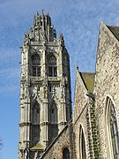 Tower of St Mary Magdalene Church
 -
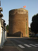 Grey Tower
 -
 Municipal Library building (15th century)
_%C3%89glise_de_la_Madeleine_Tour.jpg)

_Maison_de_la_renaissance.jpg)
Demography
| Year | Pop. | ±% |
|---|---|---|
| 1962 | 5,551 | — |
| 1968 | 6,012 | +8.3% |
| 1975 | 6,499 | +8.1% |
| 1982 | 6,698 | +3.1% |
| 1990 | 6,446 | −3.8% |
| 1999 | 6,619 | +2.7% |
| 2008 | 6,538 | −1.2% |
International relations
The town is twinned with Stowmarket, Suffolk, England.
See also
References
- ^ Téléchargement du fichier d'ensemble des populations légales en 2019, INSEE
- ^ Arrêté préfectoral 3 August 2016 (in French)
- ^ Chisholm, Hugh, ed. (1911). . Encyclopædia Britannica. Vol. 27 (11th ed.). Cambridge University Press. p. 1031.
- ^ Base Mérimée: Eglise de la Madeleine, Ministère français de la Culture. (in French)
- ^ Base Mérimée: Eglise Notre-Dame, Ministère français de la Culture. (in French)
- ^ Base Mérimée: La Tour Grise, Ministère français de la Culture. (in French)
- ^ Base Mérimée: Ancienne église Saint-Laurent, Ministère français de la Culture. (in French)
- ^ Base Mérimée: Eglise Saint-Jean, Ministère français de la Culture. (in French)
- ^ Base Mérimée: Maison de la Renaissance, dite Maison à tourelle, Ministère français de la Culture. (in French)
| International | |
|---|---|
| National | |
| Geographic | |
| Other | |
This Eure geographical article is a stub. You can help Wikipedia by expanding it. |