
Vicopisano
Vicopisano | |
|---|---|
| Comune di Vicopisano | |
 Panoramic view | |
 Coat of arms | |
.svg) Vicopisano within the Province of Pisa | |
Location of Vicopisano  | |
UTC+2 (CEST) | |
| Postal code | 56010 |
| Dialing code | 050 |
| Patron saint | St. Mary |
| Saint day | First Sunday in October |
| Website | Official website |
Vicopisano is a Monte Pisano from north.
History
In medieval times Vicopisano was a flourishing fortified center of the Republic of Pisa. It was conquered by Florence in 1406. Here a castle (Rocca Nuova) designed by Filippo Brunelleschi was built in 1434. The Pieve di Santa Maria is a 12th-century parish church built in Romanesque style.
Geography
Vicopisano borders the following municipalities: Bientina, Buti, Calci, Calcinaia, Cascina and San Giuliano Terme.[3] It counts the hamlets (frazioni) of Caprona, Cucigliana, Lugnano, Noce, San Giovanni alla Vena and Uliveto Terme.
Demographics

Economy
Economical activities include ceramics, mechanics (Piaggio) and bottling of mineral waters. The agriculture is based on olive oil and cereals.
Main sights
- Brunelleschi Rocca (castle), with an annexed Romanesque church from the 12th century
- 12 medieval towers
- Pieve di Santa Maria (12th century), with 13th-century frescoes.
- Pieve di San Jacopo
- Palazzo Pretorio (12th century)
- Palazzo della Vecchia Posta (12th century)
- Villa Fehr
Gallery
-
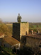 One of the towers of Vicopisano
 -
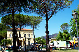 The town's square


Notable people
- Domenico Cavalca (1270-1342), writer
References
- ^ "Superficie di Comuni Province e Regioni italiane al 9 ottobre 2011". Italian National Institute of Statistics. Retrieved 16 March 2019.
- Istat.
- ^ 42583 Vicopisano on OpenStreetMap
External links
Wikimedia Commons has media related to Vicopisano.
- (in Italian) Vicopisano official website
- (in Italian) Vicopisano tourist portal

| International | |
|---|---|
| National | |
| Geographic | |