
Visbek
Visbek | |
|---|---|
 Coat of arms | |
Location of Visbek within Vechta district 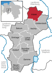 | |
 Visbek  Visbek | |
| Coordinates: 52°50′11.74″N 08°18′35.12″E / 52.8365944°N 8.3097556°E | |
| Country | Germany |
| State | Lower Saxony |
| District | Vechta |
| Subdivisions | 13 hamlets |
| Government | |
| • Mayor (2019–24) | Gerd Meyer[1] (CDU) |
| Area | |
| • Total | 84.08 km2 (32.46 sq mi) |
| Elevation | 49 m (161 ft) |
| Population (2022-12-31)[2] | |
| • Total | 10,141 |
| • Density | 120/km2 (310/sq mi) |
| Time zone | UTC+01:00 (CET) |
| • Summer (DST) | UTC+02:00 (CEST) |
| Postal codes | 49429 |
| Dialling codes | 04445, 04447 (Hagstedt) |
| Vehicle registration | VEC |
| Website | www.visbek.de |
Visbek (Old Saxon Fiscbechi) is a municipality in the district of Vechta, in the Oldenburg Münsterland region of the state of Lower Saxony, Germany.
Location and municipal subdivisions
Visbek lies on the North German Plain, approximately 12 km to the north of Vechta. The municipality consists of the village of Visbek itself, together with 13 surrounding hamlets (German: Bauerschaften), viz. Astrup, Bonrechtern, Endel, Erlte, Hagstedt, Halter/ Meyerhöfen, Hogenbögen, Norddöllen, Rechterfeld, Varnhorn/ Siedenbögen and Wöstendöllen.
Neighbouring municipalities
Neighbouring communities are (counting clockwise from north): the municipality of Großenkneten, including Ahlhorn, the town of Wildeshausen, the municipality of Goldenstedt, the town of Vechta and the municipality of Emstek.
Landscape
Visbek is the northernmost municipality in
Middle Ages
Historical tradition dates back as far as to the late 8th century, when upon order of the Frankish king
In 855 AD, King
Megalithic tombs
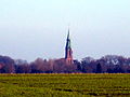
The Visbek region, however, had been populated even before the Middle Ages, in fact as far back as the Neolithic Period, as evinced by numerous megalithic tombs of the Funnelbeaker culture (3,500 - 2,800 BC) that may still be seen today. Examples - aside from the Heidenopfertisch illustrated below - include the large stone graves of Mühlensteine, Schmeersteine, Visbeker Braut and Visbeker Bräutigam.[6][7][8][9]
Media
The following regional newspapers are delivered in Visbek:
- Oldenburgische Volkszeitung, Vechta
- Nordwest-Zeitung, Oldenburg
Economy
Several companies of the meat industry are located in Visbek. The PHW Group, the largest German poultry meat producer, has its headquarters in Rechterfeld. The EW Group, the world market leader in poultry breeding and genetics, also has its headquarters in Visbek. Additionally, the Plukon Food Group runs poultry meat processing facilities in Visbek.
Regular festivities
- Every year at Pentecost, the Visbek Shooting Club, St. Hubertus, hosts its Schützenfest fun fair and folk processions.
- The annual Visbek Rockt open air music festival takes place at the end of May, featuring local and regional rock bands.
Partner municipality
![]() France A partnership with Pontvallain in the Sarthe Departement has been maintained since 1988.
France A partnership with Pontvallain in the Sarthe Departement has been maintained since 1988.
Gallery
-
 The high street (Hauptstraße) in Visbek
 -
 Gerbert Primary School, Visbek
 -
 Roman Catholic St. Vitus Parish Church, Visbek, seen from the west
 -
 Abbot Gerbert Castus Monument at St. Vitus Church, Visbek
 -
![The Heidenopfertisch , a megalithic grave near Visbek[10][11] at Engelmannsbäke](//upload.wikimedia.org/wikipedia/commons/thumb/3/39/Gro%C3%9Fsteingrab_Heidenopfertisch_02.JPG/120px-Gro%C3%9Fsteingrab_Heidenopfertisch_02.JPG)
-
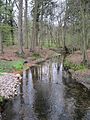 The Twillbäke stream, Bullmühle
 -

-
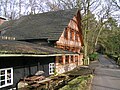 The Kokenmühle Watermill, Endel (Visbek)
 -
 The Neumühle Watermill, Endel (Visbek)


![The Heidenopfertisch , a megalithic grave near Visbek[10][11] at Engelmannsbäke](/File:Gro%C3%9Fsteingrab_Heidenopfertisch_02.JPG)


References
- Landesamt für Statistik Niedersachsen. April 2021.
- Landesamt für Statistik Niedersachsen.
- ^ Arbeitsgruppe Mühlenstraße in der Mühlenvereinigung Niedersachsen-Bremen e.V.: Kokenmühle Visbek
- ^ Arbeitsgruppe Mühlenstraße in der Mühlenvereinigung Niedersachsen-Bremen e.V.: Neumühle Visbek
- ^ Universität Marburg: Regestendatenbank. Retrieved October 30, 2013.
- ^ Stonepages: Mühlensteine. Grave 976
- ^ Stonepages: Schmeersteine. Grave 977
- ^ "Stonepages: Visbeker Braut. Grave 952". Archived from the original on 2013-10-16. Retrieved 2013-10-29.
- ^ "Stonepages: Visbeker Bräutigam. Grave 936". Archived from the original on 2013-10-16. Retrieved 2013-10-29.
- ^ Stonepages: Heidenopfertisch. Grave 974
- ^ Steinzeitreise: Heidenopfertisch. Grave 974
External links
- Official website of Municipality of Visbek
- Official website of the Catholic Parish Church of St. Vitus Visbek
- Official website of Visbek Rockt
Towns and municipalities in Vechta (district) | ||
|---|---|---|
 | ||
| International | |
|---|---|
| National | |
| Geographic | |