
Volcano Peak (Utah)
| Volcano Peak | |
|---|---|
 South aspect, from Bonneville Salt Flats | |
| Highest point | |
| Elevation | 6,011 ft (1,832 m)[1] |
| Prominence | 931 ft (284 m)[2] |
| Parent peak | Rishel Peak (6,212 ft)[3] |
| Isolation | 1.88 mi (3.03 km)[3] |
| Coordinates | 40°47′44″N 113°58′38″W / 40.7954850°N 113.9772303°W[4] |
| Geography | |
 Volcano Peak Location in Utah  Volcano Peak Volcano Peak (the United States) | |
| Location | class 3 scrambling[3] |
Volcano Peak is a 6,011-foot elevation (1,832 m) mountain summit located in Tooele County, Utah, United States.
Description
Volcano Peak is situated in the
U.S. Board on Geographic Names.[4]
Climate
Volcano Peak is set in the
drop sharply
after sunset. Summer nights are comfortably cool. Winter highs are generally above freezing, and winter nights are bitterly cold, with temperatures often dropping well below freezing.
Gallery
-

-
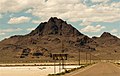
 Volcano Peak (left), Rishel Peak (left of center) and Tetzlaff Peak (right) from Bonneville Salt Flats
 -

-
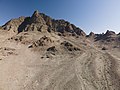 Southwest slope
 -
 South aspect
 -


See also
References
- ^ United States Geological Survey topographical map - Tetzlaff Peak
- ^ "Volcano Peak, Utah". Peakbagger.com. Retrieved 2022-08-23.
- ^ a b c "Volcano Peak - 6,011' UT". listsofjohn.com. Retrieved 2022-08-23.
- ^ a b "Volcano Peak". Geographic Names Information System. United States Geological Survey, United States Department of the Interior. Retrieved 2022-08-23.
- ^ Utah Geological Society (1960), Guidebook to the Geology of Utah, p. 173
- ISSN 1027-5606.
External links
- Volcano Peak: weather forecast