
Rishel Peak
| Rishel Peak | |
|---|---|
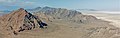
 South aspect, from Bonneville Salt Flats | |
| Highest point | |
| Elevation | 6,212 ft (1,893 m)[1] |
| Prominence | 852 ft (260 m)[2] |
| Parent peak | Tetzlaff Peak (6,267 ft)[3] |
| Isolation | 2.65 mi (4.26 km)[3] |
| Coordinates | 40°49′00″N 113°57′18″W / 40.8165958°N 113.9550075°W[4] |
| Naming | |
| Etymology | William David "Bill" Rishel[5] |
| Geography | |
 Rishel Peak Location in Utah  Rishel Peak Rishel Peak (the United States) | |
| Location | |
Rishel Peak is a 6,212-foot elevation (1,893 m) mountain summit located in Tooele County, Utah, United States.
Description
Rishel Peak is situated in the
Climate
Rishel Peak is set in the
drop sharply
after sunset. Summer nights are comfortably cool. Winter highs are generally above freezing, and winter nights are bitterly cold, with temperatures often dropping well below freezing.
Gallery
-
 Rishel Peak
 -
 Rishel Peak (left) and Tetzlaff Peak (center) seen from Volcano Peak.
Further in the distance are Graham Peak and Jenkins Peak. -
 Volcano Peak (left), Rishel Peak (left of center) and Tetzlaff Peak (right) from Bonneville Salt Flats
 -
 Rishel Peak (left) and Tetzlaff Peak (right)
 -
 Rishel Peak
 -
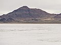 Rishel Peak from Bonneville Salt Flats


,_Bonneville_Salt_Flats_--_2022_--_2701.jpg)

See also
References
- ^ United States Geological Survey topographical map - Tetzlaff Peak
- ^ "Rishel Peak, Utah". Peakbagger.com. Retrieved 2022-08-22.
- ^ a b c "Rishel Peak - 6,212' UT". listsofjohn.com. Retrieved 2022-08-22.
- ^ a b "Rishel Peak". Geographic Names Information System. United States Geological Survey, United States Department of the Interior. Retrieved 2022-08-22.
- ^ United States Board on Geographic Names (1960), Decisions on Names in the United States, Puerto Rico and the Virgin Islands, Decision List 6001, Department of the Interior, p. 52
- ^ Hanna, Tim (2005). One Good Run: The Legend of Burt Munro.
- ISBN 9781556507267, p. 47
- ISSN 1027-5606.
External links
- Rishel Peak: weather forecast
- Life story and photo of "Big Bill" Rishel: Bangshift.com