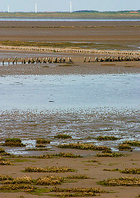
Wadden Sea National Park, Denmark
| Wadden Sea National Park | |
|---|---|
| Nationalpark Vadehavet | |
 Wadden Sea seen from Rømødæmningen | |
| Location | The Danish part of the Wadden Sea, Denmark |
| Coordinates | 55°15′00″N 8°28′59″E / 55.25°N 8.483°E |
| Area | 1,466 km2 (566 sq mi) |
| Established | 16 October 2010 (named 17 January 2008) |
| Governing body | Danish Ministry of the Environment |
| www | |
| Official name | Vadehavet |
| Designated | 14 May 1987 |
| Reference no. | 356[1] |

Wadden Sea National Park (Nationalpark Vadehavet) was designated a Danish national park on 17 January 2008, effective 2010.Varde Å valley, and many of the marshlands of Tjæreborgmarsken, Ribemarsken, Margrethekogen and De Ydre Diger in Tøndermarsken.
The Wadden Sea is internationally known as a resting place for millions of
blue mussels
. It provides habitat for more than 500 species of plants and animals.
Because of its unique biodiversity and intact intertidal ecosystem, since 2014 it has constituted the Danish part of the .
97% of the national park is part of
dunes
.
Motivation
The official motivation behind Wadden Sea National Park (Denmark) was to strengthen:[2]
- Nature protection
- Cultural history
- Outdoor activities
- Education and research
- International cooperation
See also
- List of national parks of Denmark
- Wadden Sea National Parks
- The Wadden Sea Centre
- Marsk Tower
References
- ^ "Vadehavet". Ramsar Sites Information Service. Retrieved 25 April 2018.
- ^ a b c Nationalpark Wadden Sea Vadehavets formidlerforum (the collaboration of 'Wadden Sea communication forum') (in Danish)
- ^ Wadden Sea World Heritage Site at waddensea-worldheritage.org. Retrieved on 29 April 2010.
External links
Wikimedia Commons has media related to Wadden Sea National Park.

