
Werribee River
This article needs additional citations for verification. (January 2008) |
| Werribee | |
|---|---|
Werribee | |
| Physical characteristics | |
| Source | Great Dividing Range |
| • location | Wombat State Forest near Korweinguboora |
| • coordinates | 37°26′S 144°10′E / 37.433°S 144.167°E |
| • elevation | 501 m (1,644 ft) |
Werribee South | |
• coordinates | 37°58′42″S 144°41′40″E / 37.97833°S 144.69444°E |
• elevation | 9 m (30 ft) |
| Length | 110 km (68 mi) |
| Basin features | |
| River system | Port Phillip catchment |
| Tributaries | |
| • left | Lerderderg River, Toolern Creek |
| National park | Werribee Gorge State Park |
| [3][4] | |
The Werribee River is a
The river flows through the
The
Etymology
The
History

Before the arrival of settlers, the Werribee River was the boundary of the
.In the late 1830s and 1840s, the Werribee River was the scene of conflict between the
In 1851, a substantial timber bridge was built to cross the Werribee River to replace an earlier wooden bridge. In 1852, this bridge was washed away when the Werribee river flooded.[6]
In August 2004, the Victorian Government pledged A$300,000 (equivalent to A$472,648 in 2022) towards restoring the Werribee River, removing willows choking the river around the township and replacing them with native plants in a habitat restoration project.
Fishing
Werribee River holds fish all along its course, most of which are at the mouth of the river into
Features and highlights

Behind the Werribee golf course, the K-Road cliffs are perhaps the most unusual feature of the river, being sometimes described as looking like a river in Arnhem Land in the Northern Territory.[according to whom?]
Gallery
-
 Running through parkland in Ballan
 -
 Under the old Western Highway at Ballan
 -
 A ford across the river west of Bacchus Marsh
 -
 Marking the boundary between Bacchus Marsh and Maddingley
 -
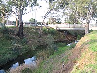
 In flood over Cotrell Street in Werribee


See also
References
- ^ Victorian Aboriginal Corporation for Languages.
- ^ ISBN 0-589-50128-3.
- ^ "Place Details: Werribee River". VICNAMES. Government of Victoria. Archived from the original on 7 April 2014. Retrieved 24 April 2018.
- ^ "Map of Werribee River, VIC". Bonzle Digital Atlas of Australia. Retrieved 7 April 2014.
- ^ "Werribee River". City of Wyndham.
- Geelong Advertiser and Intelligencer. Vol. XI, no. 1785. Victoria, Australia. 25 May 1852. p. 2 (DAILY and MORNING). Retrieved 29 June 2022 – via National Library of Australia.
External links
Waterways of the Melbourne Water catchment, Victoria, Australia | |
|---|---|
| Rivers |
|
| Creeks |
|
| Lakes |
|
| Drains | Bunyip Main Drain
Wylies Drain |
| Other | |