
West and East Mitten Buttes

| West Mitten Butte | |
|---|---|
NGVD 29[1] | |
| Prominence | 856 ft (261 m)[1] |
| Coordinates | 36°59′27″N 110°05′46″W / 36.9908349°N 110.096237°W[2] |
| Geography | |
| Location | Monument Valley, Arizona, U.S. |
| Topo map | USGS Mitten Buttes |
| East Mitten Butte | |
|---|---|
NGVD 29[3] | |
| Prominence | 1,026 ft (313 m)[3] |
| Coordinates | 36°59′18″N 110°04′11″W / 36.988335°N 110.069847°W[4] |
| Geography | |
| Location | Monument Valley, Arizona, U.S. |
| Topo map | USGS Mitten Buttes |
The West and East Mitten Buttes (also known as the Mittens) are two
mittens
with their thumbs facing inwards.
The Mittens are about 0.6 mi (0.97 km) from the Arizona–Utah state line and West Mitten Butte is 1.1 mi (1.8 km) northeast of the park headquarters.[5] The summit of West Mitten Butte is 6,176 ft (1,882 m)[1] and East Mitten Butte is 6,226 ft (1,898 m)[3] in elevation. The Mittens form a triangle with Merrick Butte about 2⁄3 mi (1.1 km) to the south and, with Sentinel Mesa, a more extensive plateau, towards the northwest. At the end of March and mid-September, for a few days only at sunset, the Mitten Shadow[6] occurs, when the West Mitten shadow appears on the East Mitten.
The buttes are made of three principal rock layers. The lowest layer is
de Chelly Sandstone, and the top layer is the Moenkopi Formation, capped by Shinarump Conglomerate
.
Gallery
-
 West Mitten Butte, East Mitten Butte and Merrick Butte
 -
 West Mitten Butte, East Mitten Butte and Merrick Butte before sunrise
 -
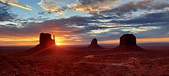 Sunrise by the Mitten Buttes
 -
 The Mittens and Merrick Butte (right foreground) form a triangle in Monument Valley.


Wikimedia Commons has media related to West and East Mitten Buttes.
References
- ^ a b c "West Mitten Butte, Arizona". Peakbagger.com. Retrieved 2016-08-22.
- ^ "West Mitten Butte". Geographic Names Information System. United States Geological Survey, United States Department of the Interior. Retrieved 2016-08-22.
- ^ a b c "East Mitten Butte, Arizona". Peakbagger.com. Retrieved 2016-08-22.
- ^ "East Mitten Butte". Geographic Names Information System. United States Geological Survey, United States Department of the Interior. Retrieved 2016-08-22.
- ISBN 0-89933-325-7.
- ^ "Monument Valley in Arizona - Best Time". Best Time 2 Travel. 2022-04-01.