
Wiernsheim
Wiernsheim | |
|---|---|
![Hindenburgstraße, with St. Maurice's Church, Wiernsheim [de] visible](/File:Hindenburgstra%C3%9Fe_in_Wiernsheim_mit_Mauritiuskirche_-_panoramio.jpg) Hindenburgstraße, with St. Maurice's Church, Wiernsheim visible | |
 Coat of arms | |
Location of Wiernsheim within Enzkreis district 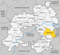 | |
 Wiernsheim  Wiernsheim | |
| Coordinates: 48°53′24″N 8°51′2″E / 48.89000°N 8.85056°E | |
| Country | Germany |
| State | Baden-Württemberg |
| Admin. region | Karlsruhe |
| District | Enzkreis |
| Government | |
| • Mayor (2022–30) | Matthias Enz[1] (SPD) |
| Area | |
| • Total | 24.62 km2 (9.51 sq mi) |
| Elevation | 366 m (1,201 ft) |
| Population (2022-12-31)[2] | |
| • Total | 6,854 |
| • Density | 280/km2 (720/sq mi) |
| Time zone | UTC+01:00 (CET) |
| • Summer (DST) | UTC+02:00 (CEST) |
| Postal codes | 75446 |
| Dialling codes | 07044 |
| Vehicle registration | PF |
| Website | www |
Wiernsheim is a municipality in the
History
Wiernsheim became a possession of Maulbronn Monastery in 1259 and was governed by the monastery's district office until 1806. When Maulbronn became a possession of the Duchy of Württemberg in 1504, Wiernsheim and the village of Iptingen also became part of the Duchy. The villages of Pinache and Serres were founded in 1699 by Waldensians fleeing persecution in Piedmont. On 18 March 1806, the administrative district of Maulbronn was reorganized into an Oberamt, to which Wiernsheim and Iptingen were assigned. Iptingen was reassigned around 1842 to the jurisdiction of Vaihingen. It was joined on 1 October 1938 when the district of Maulbronn was dissolved and its constituents were assigned to the new Landkreis Vaihingen. On 1 January 1970, Wiernsheim incorporated Pinache. As part of 1973 Baden-Württemberg district reform, Wiernsheim, Iptingen, and Serres were assigned on 1 January 1973 to the newly-created Enz district. The next year, Wiernsheim incorporated Iptingen and Serres.[3]
Geography
The municipality (
Coat of arms
Wiernsheims' municipal
References
- ^ Bürgermeisterwahl Wiernsheim 2022, Staatsanzeiger.
- Statistisches Landesamt Baden-Württemberg. June 2023.
- ^ a b c "Wiernsheim". LEO-BW (in German). Baden-Württemberg. Retrieved 26 June 2020.

| International | |
|---|---|
| National | |