
Wikipedia:Graphics Lab/Map workshop/Archive/2017/Oct 2017
| This page is an archive. Do not edit the contents of this page. Please direct any additional comments to the current main page. |

Crusades


- Article(s)
- Request
- Comment at Featured Article Review: Some of the images look like they are missing a source (and licensing) for the underlying mapping - e.g. :File:Map Crusader states 1135-en.svg, :File:Seljuk Empire locator map.svg, :File:Deutscher Orden in Europa 1300.png. The coastline, rivers etc. look very detailed, and that they've come from somewhere other than the author who did the overlay etc., but I can't see where this is detailed. Norfolkbigfish (talk) 15:53, 5 June 2017 (UTC)
- Graphist opinion(s)
- The second one says "In general, the map was based on Shepherd and on Hall & Haywood, with modifications based on Grousset and Hourani". The third says "Karte nach: Grosser Historischer Weltatlas. Bayrischer Schulbuch-Verlag (Hg.). Bd. 2, Mittelalter. München 1970, S. 82." Maproom (talk) 16:03, 5 June 2017 (UTC)
- Do you know the licensing situation on these, please (and a source for 1)? Norfolkbigfish (talk) 18:34, 5 June 2017 (UTC)
Female monarchs
- Article(s)
- List of elected and appointed female heads of state and government
- Request
- The name of the article will be changed to "List of female heads of state and government" to also include countries where a female was a monarch head of State. It needs a map to show the countries where a female was head of State or government, even if she was not elected (monarch). Thank you. -- talk) 10:03, 30 June 2017 (UTC)
- Graphist opinion(s)
@
Women's suffrage in the United States
-
 US states by women's voting rights, 1920

- Article(s)
- Nineteenth Amendment to the United States Constitution and Women's suffrage in the United States, plus several on other projects
- Request
- The extremes (full suffrage and none at all) somehow use identical colors. Could you switch one of the colors to something else, e.g. black or white? Four of the foreign articles using this image (de:Geschichte der Vereinigten Staaten, pl:19. poprawka do Konstytucji Stanów Zjednoczonych, ru:Девятнадцатая поправка к Конституции США, and uk:Дев'ятнадцята поправка до Конституції США) put a color key in the image caption, so these will have to be updated, but it's likely just a matter of changing the color hex. -- Nyttend (talk) 23:34, 26 July 2017 (UTC)
- Graphist opinion(s)
- @Nyttend: I'm confused. Aren't the extremes red (no suffrage) and green (full suffrage)? – Joe (talk) 06:24, 27 July 2017 (UTC)
- I assume Nyttend is red-green colorblind. Incidentally – I've found that constructing color scales so that they're useful to colorblind readers is difficult. Does Wikipedia have any good advice on it? Maproom (talk) 08:20, 27 July 2017 (UTC)
Central Balkans in the 1380s - Translation
- Source
File:Central balkans 1373 1395V1.svg
- Article(s)
- Battle of Bileća and likely many others
- Request
Simple translation from Spanish. Surtsicna (talk) 14:11, 5 August 2017 (UTC)
- Graphist opinion(s)
Translation from what to what and where is the translation? --Goran tek-en (talk) 16:00, 5 August 2017 (UTC)
- From Spanish (^^) to English. The translation is requested. A map where it says "Kingdom of Bosnia" instead of "Reino de Bosnia" would be helpful on this Wikipedia. Surtsicna (talk) 18:38, 5 August 2017 (UTC)
- I can do the rest – but how would you translate "Serbia del Morava"? Maproom (talk) 18:47, 5 August 2017 (UTC)
- – and – is "Rey Marko" someone's name, or does it translate as "king Mark" (and what was he king of?). Maproom (talk) 18:50, 5 August 2017 (UTC)
- Translations seem to be in the description of the file:
Realm of Prince Lazar (Moravian Serbia)
Realm of Zeta
Realm of King Marko
Realm of Constantine Dragaš (Principality of Velbazhd)
Realm of Vuk Branković
8.40.151.110 (talk) 23:24, 5 August 2017 (UTC)
- "Moravian Serbia"? Is this a reference to Great Moravia, which had lost control of the area by 907? Or to some other nation called Moravia? Maproom (talk) 06:24, 6 August 2017 (UTC)
- Sorry, I should have explained that. It's a reference to the river Morava in Serbia and its tributaries. It's not connected to the Czech land. There's a more detailed explanation at Moravian Serbia. The translations quoted by the anonymous user are correct. Surtsicna (talk) 11:17, 6 August 2017 (UTC)
- I'm sorry, I'll have to give up on this. The problem isn't the translation; with your help, I now know how to translate all the names. The problem is with the structure of the SVG file.
- I want to translate "VALAQUIA" as "WALLACHIA". The file contains the string "VALAQUIA" exactly once, as the text of a text element. But replacing it by "WALLACHIA" has no effect. Indeed, deleting the text element has no effect. Deleting all the text elements has no effect, as if they were only there for decorative purposes, or to bulk up the file. All the text is in fact generated by path elements, which I lack the tools and skills to modify.
- I don't know how people create SVG files like this, and I certainly don't know why they do it. I guess it's something to do with the notion that vector graphic files are always better in all respects than raster graphics files, even when they clearly aren't.
- Surtsicna, I apologise for this rant. It's nothing to do with you, it's directed at the cretins who create SVG files that are much harder to modify than old-style bitmaps. But it means, sadly, that I won't be able to help with this particular project. Maproom (talk) 13:34, 6 August 2017 (UTC)
![]() Done. In English, on Commons, and 2200 lines of garbage removed. Maproom (talk) 16:28, 6 August 2017 (UTC)
Done. In English, on Commons, and 2200 lines of garbage removed. Maproom (talk) 16:28, 6 August 2017 (UTC)

Kirarahama (Yamaguchi)
- Article(s)
- Kirarahama (Yamaguchi)
- Request
- please create Wikipedia-style location map, as this one is up for deletion… -- Kintetsubuffalo (talk) 01:41, 17 August 2017 (UTC)
- Graphist opinion(s)
 Done. @Kintetsubuffalo: I've added a location map to the article using {{OSM Location map}}. Feel free to adjust the parameters as you see fit. – Joe (talk) 19:46, 22 September 2017 (UTC)
- Thanks for adding it! That's great!--Kintetsubuffalo (talk) 00:44, 23 September 2017 (UTC)
Conversion of several images, representing a hand written map into a proper map
- Article(s)
- German Radio Intelligence Operations during World War II
- Request
- Hi, I am looking for several other maps to be created in the same manner as the maps created beforehand at the request Three German intercept operation maps during world war II. I am currently creating a new section in the article, and it has several maps, I think. I have also missed a map, for some reason, which was for a previous section.
The request is: Please mapify the five hand written maps found at:
https://archive.org/details/41748999078819
The maps representing intercept operations for the Germany Sig Int organization, and are hand drawn by General Albert Praun himself, who was head of Signal Intelligence for the German Army during World War II ,as part of TICOM homework. The maps I am looking for are:
- Chart 2, page 15. It is a very simple map.
- Chart 4, page 31. This fairly complex, which shows the German intercept operations on the front, as they advance into northern France.
- Chart 6, page 55. German radio intercept in the Med. Medium, I'd say. Not a huge amount of info in it.
- Chart 7, page 61. Intercept ops on March 1943, by Germany. Fairly easy, I'd say.
- Chart 9, page 88. Operations in southern Russia. Very complex. May need to leave to next round. If too much, please say so.
Three charts are simple, two are complex. That last one is very complex. It could be too much. Thanks very much. scope_creep (talk) 15:29, 22 August 2017 (UTC)
I have not included scan of the images, as I can't seem to get them in focus, when I am screen printing them, so the detail is lost. scope_creep (talk) 15:31, 22 August 2017 (UTC)
- Note, the document download options are below the main viewing windows. If images are needed for viewing, I can upload them. Thanks.scope_creep (talk) 15:51, 22 August 2017 (UTC)
Update I have upload the images, since I had a bit of time. Looking at them, No 2. is probably the most beefy, 5 is fairly complex, but it seems to be just a bunch of lines. Hope that helps. scope_creep (talk) 18:08, 28 August 2017 (UTC)
- Graphist opinion(s)
I guess it makes sense that I continue with those. ![]() Request taken by Goran tek-en (talk) 18:13, 2 September 2017 (UTC).
Thanks Goran tek-en. scope_creep (talk) 21:15, 2 September 2017 (UTC)
Request taken by Goran tek-en (talk) 18:13, 2 September 2017 (UTC).
Thanks Goran tek-en. scope_creep (talk) 21:15, 2 September 2017 (UTC)
- @Scope creep: Now there is a draft for #1, feedback, thanks. --Goran tek-en (talk) 17:19, 3 September 2017 (UTC)
- @Goran tek-en: It's pretty decent all in all. scope_creep (talk) 18:48, 3 September 2017 (UTC)
- Name: Chart 2 German radio intelligence operations during Norwegian Campaign between 31 March 1940 to 14 June 1941
- Description:Intercept units movements during Signal intelligence operations by Germany against Norway 31 March 1940 to 14 June 1941
- Category:Germany in World War II
@Scope creep: Now you can find it here Commons:file:Chart 2 German radio intelligence operations during Norwegian Campaign between 31 March 1940 to 14 June 1941.svg. --Goran tek-en (talk) 17:32, 4 September 2017 (UTC)
Wikipedia Main vs. commons

vodsk
gabat
This code works on main Wikipedia. When loaded into Commons/User page/discussion it fails. Errors start immediately after "places =". What did I do wrong?Benjamin Trovato (talk) 20:53, 31 August 2017 (UTC)
- Benjamin Trovato, I think it should work now - see this test. To make it work, I needed to create c:Template:Location map Turkmenistan on Commons, which didn't exist. There are warnings about co-ords in the template page, but they don't affect transclusions, as they are "noinclude", so this might be enough for your purpose. -- Begoon 00:29, 7 October 2017 (UTC)
- Thanks. On my end, consider it closed. On your end you might look for a general problem, or do whatever you think wise. Benjamin Trovato (talk) 02:22, 7 October 2017 (UTC)
- Actually, this edit I subsequently made to c:Template:Location map/Info, using
"Inline coordinates"
instead of"coord"
seems to have cleared the warning, so I think that's all done now. -- Begoon 02:52, 7 October 2017 (UTC)
- Actually, this edit I subsequently made to c:Template:Location map/Info, using
- Thanks. On my end, consider it closed. On your end you might look for a general problem, or do whatever you think wise. Benjamin Trovato (talk) 02:22, 7 October 2017 (UTC)
File:India (orthographic projection).svg
-
 Map of India with territory controlled in dark green, claimed but uncontrolled territory in light green.
.svg)
- Article(s)
- India
- Request
- The Siachen Glacier is currently controlled by India since 1984, and is disputed by Pakistan as it is a part of Jammu and Kashmir, which is entirely disputed by Pakistan. Sources - [1][2][3][4] On the current map, Siachen is not shown. Map of Jammu and Kashmir with Siachen - File:Kashmir map.svg. Request someone to look into the issue. Thanks-- King Prithviraj II (talk) 17:13, 23 September 2017 (UTC)
- Graphist opinion(s)
@King Prithviraj II: For me this is not the right place for a request like that, if I understand you right. We don't do research or similar here, we do graphic work. If you want someone to look in to, or to discuss a disputed area I guess that would be better on the talk page of the article. We do not (generally) have any knowledge of the subjects and we can only work upon straight forward requests. If I misunderstood you just tell me and I will strike this thru, thanks. --Goran tek-en (talk) 18:00, 23 September 2017 (UTC)
- @Goran tek-en: I meant to submit a straight forward request to modify the map to include Siachen in dark green. Sorry for not being specific enough. King Prithviraj II (talk) 18:04, 23 September 2017 (UTC)
- @King Prithviraj II: Is this what you want? Please ping me. --Goran tek-en (talk) 18:33, 19 October 2017 (UTC)
@Goran tek-en: Yes, thats exactly what I meant, Thanks. Please upload it at the same location as the previous image to avoid breaking links. Thanks again, King Prithviraj II (talk) 20:41, 20 October 2017 (UTC)
![]() Done @King Prithviraj II: New version uploaded. If you are happy with this please put the code
Done @King Prithviraj II: New version uploaded. If you are happy with this please put the code {{resolved|1=~~~~}} on this request so it can be archived, thanks. --Goran tek-en (talk) 14:05, 21 October 2017 (UTC)
- References
- ^ Gauhar, Feryal Ali; Yusuf, Ahmed (2 November 2014). "Siachen: The place of wild roses". Retrieved 4 August 2017.
- ^ North, Andrew (12 April 2014). "Siachen dispute: India and Pakistan's glacial fight". Retrieved 4 August 2017 – via www.bbc.com.
- ^ "India gained control over Siachen in 1984 - Times of India". Retrieved 4 August 2017.
- ^ "The Siachen Story, then and Now".
Treaty of Salynas
-

-
 Done by Offnfopt


- Article(s)
- Treaty of Salynas
- Request
- please make the colors less, um, garish and more wikilike… -- Kintetsubuffalo (talk) 02:21, 12 October 2017 (UTC)
- Graphist opinion(s)
Kintetsubuffalo I don't think this counts as "wikilike" but it at least doesn't burn your retinas, see File:Teutonic state 1308-1455.svg. - Offnfopt(talk) 05:47, 16 October 2017 (UTC)
- Offnfopt That's fantastic! Much more Lord of the Rings/Game of Thrones! Hahahahaha! I was just going to comment here when I got your note! Do me a favor, and if it's no good we can revert. Please make water bodies white, see if that makes it a tad less foreboding. But it seriously does rock! Thanks again!--Kintetsubuffalo (talk) 09:37, 17 October 2017 (UTC)
- PS-thank you for aligning the shading with rump nations and territorial gains/losses, that's fantastic!--Kintetsubuffalo (talk) 09:40, 17 October 2017 (UTC)
- PPS-it should read "Ostsee". (or Baltic is fine since the rest is in English...)--Kintetsubuffalo (talk) 09:41, 17 October 2017 (UTC)
- Kintetsubuffalo I had tried white water first when I was trying to come up with a color palette to work but I didn't like it, I went ahead though and uploaded a revision so you could see but I have the current revision still selected on blue water. The current revision now is also changed to Baltic Sea. - Offnfopt(talk) 23:20, 17 October 2017 (UTC)
- PPS-it should read "Ostsee". (or Baltic is fine since the rest is in English...)--Kintetsubuffalo (talk) 09:41, 17 October 2017 (UTC)
- PS-thank you for aligning the shading with rump nations and territorial gains/losses, that's fantastic!--Kintetsubuffalo (talk) 09:40, 17 October 2017 (UTC)
- Go Team Blue! Looks better on this monitor, thanks so much!--Kintetsubuffalo (talk) 13:37, 18 October 2017 (UTC)
A locator map of Europe in 1939?
- Article(s)
- Basis Nord
- Request
- I wonder whether a historical map of Europe in 1939 is needed for that page. The present version shows the boundaries of XXI century.-- Carnby (talk) 18:27, 12 March 2017 (UTC)
- Graphist opinion(s)
- @Carnby: I am not sure which of these you want, but I am pretty sure it exists already.

- @Carnby and Lommes: Unfortunately I can't find any information on what the boundaries or projection of those maps are, so it's not possible to add it as a location map. Someone would have to reconstruct the precise boundaries/projection (v. difficult) or create a new map from scratch with known parameters. – Joe (talk) 12:51, 9 July 2017 (UTC)
New Philadelphia Location map
-
 Philadelphia Location map

- Article(s)
- Many, but Watson Comly School, for example
- Request
- Can a new location map for Philadelphia be uploaded? The current image is cut too low at the northern edge of the city, so the valid coordinates at Watson Comly School are outside of the map. Also, is there a better version that's less cluttered than OSM? kennethaw88 • talk 18:57, 18 March 2017 (UTC)
- Graphist opinion(s)
- @Kennethaw88: I would suggest moving to the fantastic new {{OSM Location map}} template instead. For example, for Watson Comly School:

{{OSM Location map
| coord = {{coord|39.95|-75.166667}}  <!-- coordinates of Philadelphia -->
| mark-coord = {{coord|40.1266|-75.0128}}
| zoom = 9
}}
- The downside is that it isn't yet integrated into most infoboxes. – Joe (talk) 13:05, 9 July 2017 (UTC)
Sur Empire

- Article(s)
- Sur Empire
- Request
- Hi. Please make "Qandahār" the easternmost boundary of the "Safavid Empire" (yellow), and give the area directly to the east of it the same brown-ish (earthern) color as we can see in other major parts of the map. In other words, there must be a brown-colored territory between Kandahar, and the green territory (Sur Empire). All areas to the north of Qandahār (e.g. everthing surrounding "Ghazni" and "Kabul", and to the north of both) have to be colored with the same brown-ish shade as well. Thanks much in advance -- LouisAragon (talk) 03:22, 27 March 2017 (UTC)
- Graphist opinion(s)
Right-wing populism map
-
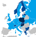 Right-wing populist parties in European national parliaments
.png)
- Article(s)
- Right-wing populism
- Request
- Please can someone update this map. UKIP no longer has presence in UK Parliament. There are currently right-wing populists in the national legislatures of Estonia, Turkey, Serbia, Belarus, Macedonia, Albania, Montenegro, Bosnia, Luxembourg. -- Jay942942 (talk) 19:04, 5 April 2017 (UTC)
- Graphist opinion(s)
-
- If I understand the legend correctly, the current coloring indicates that no right-wing populists are in the national legislature; it seems to indicate that the R-W P presence is only in a subnational legislature, which in this case is Wales. Is UKIP in the Welsh Assembly or anywhere else? If they're nowhere at all, of course the coloring can be removed. Nyttend (talk) 23:13, 12 April 2017 (UTC)
- It seems to be that the legend is wrong. For example, Netherlands, France, Belgium are all the same color as the United Kingdom, but all those three currently have right-wing populists in their national legislature. Also, right-wing populists are in regional legislatures in Germany, which is shaded grey. It seems that the darkest blue indicates they lead the government (Hungary, Poland), the slightly lighter shade indicates they are in government but not leading the government (Greece, Slovakia, Finland) and the lightest shade indicates presence in national legislature. UKIP has no presence in the British national legislature, but still does have presence in the Welsh Assembly.--Jay942942 (talk) 13:03, 21 April 2017 (UTC)
- The UK's coloring should remain in reference to the Democratic Unionist Party, although the description should be modified.--Jay942942 (talk) 23:49, 22 July 2017 (UTC)
- If I understand the legend correctly, the current coloring indicates that no right-wing populists are in the national legislature; it seems to indicate that the R-W P presence is only in a subnational legislature, which in this case is Wales. Is UKIP in the Welsh Assembly or anywhere else? If they're nowhere at all, of course the coloring can be removed. Nyttend (talk) 23:13, 12 April 2017 (UTC)
Location Map Onondaga County, New York
I'm looking how to create a location map for Onondaga County like this one this one for San Diego County.
https://commons.wikimedia.org/wiki/File:Onondaga_County_New_York_incorporated_and_unincorporated_areas.svg Countyparkour (talk) 22:29, 11 April 2017 (UT->
Treaty of Küçük Kaynarca.svg
-
 Treaty of Küçük Kaynarca
- Article(s)
- Treaty of Küçük Kaynarca
- Request
- Hi. Please remove all green areas in "Circassia" and "Gurdjistan", except for the coastal areas in Gurdjistan, and change them into the color orange. Also, "Dagestan", as well as anything to the east and south of "Kabardia", as well as Central and Eastern Georgia need to be colored orange. In short; the only thing that should remain green in that area (aka Caucasus), is the coastal area of Gurdjistan/Georgia, and of course Kabardia needs to remain within that type of red/green shading. Everything else should be shaded orange. This is pretty important, as the one who made this map, made some absurd pseudo-historic additions (most likely unintentionally, of course). Thanks - LouisAragon (talk) 17:23, 18 April 2017 (UTC)
- Graphist opinion(s)
Location map for Salvador, Bahia

- Article(s)
- São Marcelo Fort
- Federal University of Bahia
- Jorge Amado University Center
- São Francisco Church and Convent
- Estádio Fonte Nova
- Swimming Olympic Centre of Bahia
- Estádio Parque Santiago
- Archbishop's Palace of Salvador
- Church of the Blessed Sacrament at Rua do Passo
- Ilê Axé Opô Afonjá
- Church of Saint Peter of the Clergymen
- Rio Branco Palace
- House of the Seven Lamps
- Ilê Axé Iyá Omin Iyamassê
- Request
- Badly needed: a location pushpin map for the city of Salvador, possibly simply titled "Brazil Salvador". It already exists in the Portuguese Wikipedia as "Região Metropolitana de Salvador". Thanks if possible -- Prburley (talk) 13:20, 20 April 2017 (UTC)
- Graphist opinion(s)
@Prburley: Don't the editors create them themselves with this template Template:Location_map. --Goran tek-en (talk) 18:28, 12 July 2017 (UTC)
- @Goran tek-en: I just didn't understand the documentation but I'll give it another try. Maybe I'm missing something. Thanks! Prburley (talk)
Legislative Districts of Laguna
-
Map of Legislative Districts of Laguna
- Article(s)
- Request
I'd like to request a change on this map here. I mean, it's factually correct, but it's not really a good looking map. Might I suggest filling in the towns/cities with a color instead of having dots? Thanks guys. NyanThousand (talk) 06:01, 28 April 2017 (UTC)
- Graphist opinion(s)
Have you seen the map at Laguna (province)#Administrative divisions? Maproom (talk) 06:31, 28 April 2017 (UTC)
- I guess you're referring to File:Ph fil laguna.png? See, the thing about that map is that it details municipalities and cities, not legislative districts. So yeah, two sort of different things. NyanThousand (talk) 11:09, 28 April 2017 (UTC)
- The municipalities of one are exactly identical to the legislative districts of the other, and are shown with the same names, identically placed. Are you saying that you want the city dots to be retained, but given shapes showing the city boundaries? Maproom (talk) 12:44, 28 April 2017 (UTC)
- Maybe the dots aren't cities, and you want their colour spread over the whole district each is in? Maproom (talk) 17:00, 28 April 2017 (UTC)
- Yeah, something like that. Color in the cities by legislative district instead of having dots. Or maybe a map of the province (without the cities) divided by district. Though I think having city boundaries would be more useful, information-wise. NyanThousand (talk) 03:33, 29 April 2017 (UTC)
Afsharid

- Article(s)
- Afsharid
- Request
- please superimpose modern boundaries for context… -- Kintetsubuffalo (talk) 22:28, 7 May 2017 (UTC)
- Graphist opinion(s)
Additions of Municipality of Morang district

- Article(s)
- Morang district
- Request
- Biratnagar Sub-metropolitan City is only mentioned in the image. Please color additional municipalities of Morang district mentioned below and rename them after the new name proposed in case of municipalities made by merging Village Development Committees:
Government Sources:Ministry of Federal affairs and local development's latest administrative division
- Sundar Dulari Municipalitymerged to Sundar Haraicha Municipality
- BelbariMunicipality
- Pathari-Sanischare Municipality
- UrlabariMunicipality
- RangeliMunicipality
- Letang BhogateniMunicipality
- RatuwamaiMunicipality
Thames Valley National Character Area
- Article(s)
- Thames Valley
- Request
- Please could we have an area map of the Thames Valley National Character Area. It's Profile 115, linked here. There is an OGL dataset available here. Maps will be needed eventually for every National Character Area, but I'm only specifically looking for this one. -- Dissidentplasterer (talk) 14:50, 7 June 2017 (UTC)
- Graphist opinion(s)
- This would be a simple enough job if we had the data but I can't for the life of me figure out where you download it on that page! – Joe (talk) 22:47, 2 July 2017 (UTC)
Oahu districts
- Article(s)
- Ewa District, Hawaii
- Request
- Please create a full map of Oahu of the district (moku) of the island. See these examples for a guide: [1], [2], [3]. Please use the correct punctuation and spelling, the ʻOkina should not be an Apostrophe and also use the spellings Koʻolauloa and Koʻolaupoko not Koʻolau Loa or Koʻolau Poko. After the full map is created: please create individual maps highlighting the individual districts, see commons:Category:SVG locator maps of modern Hawaiian districts (Hawaii County) for example.--KAVEBEAR (talk) 20:35, 13 June 2017 (UTC)
-- KAVEBEAR (talk) 20:35, 13 June 2017 (UTC)
- Graphist opinion(s)
Homeric Greece map

- Article(s)
- Many,
- Homer
- Ancient Greek
- Geography of the Odyssey, for example
- Request
- Please fix Achilles location. His hometown was Farsala. See here for more informations[[4]].
-- kmpania17 (talk) 08:23, 3 July 2017 (UTC)
- Graphist opinion(s)
- @Kmpania17: This map is well referenced and widely used across the different versions of Wikipedia. I'd hesitate to make any changes without a solid source and a consensus amongst editors who work on ancient Greece-related topics. – Joe (talk) 13:35, 3 July 2017 (UTC)
Locator maps of Australian states showing the capital city
-
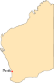 The prototype: Western Australia (with Perth)
 -
 New South Wales (without Sydney)
 -
 Queensland (without Brisbane)
 -
 South Australia (without Adelaide)
 -
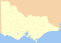 Victoria, Australia (without Melbourne)
 -
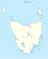 Tasmania (see below)


- Article(s)
- Portal:Sydney, Portal:Brisbane, Portal:Adelaide, Portal:Melbourne
- Request
- I would like someone to create a set of locator maps equivalent to the one at above left showing Victoria, Australia (so as to show the location and name of Melbourne). There are also some other reasonable equivalents, eg a map of Queensland without the LGA boundaries marked can be found at File:Australia Queensland location map blank.svg. If you don't already know the precise locations of the relevant cities, they can be found (including in terms of coordinates) in the infoboxes of the linked articles about those cities. Thanks in advance -- Bahnfrend (talk) 14:06, 9 July 2017 (UTC)
- Graphist opinion(s)
- Is there already one for Hobart and Tasmania? Nyttend (talk) 21:16, 10 July 2017 (UTC)
- Not one that I could find. I haven't created a Portal:Hobart yet, either (the page is just a redirect at the moment). I'm concentrating on the bigger cities right now. But in case someone wants to create a suitable map for a future portal, I've added a suitable reasonably equivalent map of Tasmania to the gallery above. Bahnfrend (talk) 12:28, 11 July 2017 (UTC)
Map of old Tyrol

- Article(s)
- Tyrol
- Request
- Could you please add Valvestino, Magasa and Pedemonte to the map? In the purple Trentino part, please add also the boundaries of the 16 districts (Districts_of_Trentino-Alto_Adige/Südtirol#Trentino) in the same colour grey like the other ones, and their respective capital cities. Feel free to upload over existing file. Thank you. -- Gryffindor (talk) 07:01, 14 July 2017 (UTC)
- Graphist opinion(s)
Map of Homeric Greece
- Article(s)
- Homer,
- Trojan War,
- Mycenae, etc
- Request
- Please fix the Achilles location on the map. The source of map (in the doc of Achilles) say that he was born in Pharsalus (Thessaly).
Please take a look to these details from the document about Achilles, by Carlos Parada:
Achilles: When Peleus (who is counted among the ARGONAUTS and the CALYDONIAN HUNTERS) left Aegina, he came to Phthia, in southern Thessaly, where Eurytion 2 was king..... General at fifteen: In that way Achilles, then fifteen years old, became Leader of the Myrmidons, a people of Phthia, to lead them against Troy... First years: It is told that Achilles was born in Pharsalus (Thessaly), and that he was the seventh child of Thetis and Peleus.
You can see about the geography of Ancient Thessaly here: [5]
Thank you! -- Archaeologos.v.n (talk) 09:09, 18 July 2017 (UTC)
- Graphist opinion(s)
- Note the arrows on that map are pointing to the colored regions, not the cities. While it isn't labeled, the light blue colored region that Achilles arrow is pointing at is Phthia. Kmusser (talk) 19:55, 3 August 2017 (UTC)
Location map for Asia-Pacific
- Request
- Would it be possible to make a Location map for the Asia-Pacific region? The map would cover everything from the Indian subcontinent to the Pacific islands, and from the Korean peninsula to Australia and New Zealand. The map would be used with {{Location map}} and it should be in the same style as:

- Thanks! talk) 11:07, 28 July 2017 (UTC)
Urartu
-
 Urartu, 9th–6th centuries BC.

- Article(s)
- Urartu
- Request
- Hi, please adjust the borders of this map, according to this source (click on "FIGURE 1", first alinea). -- LouisAragon (talk) 02:24, 23 August 2017 (UTC)
- Graphist opinion(s)
Location map of Morocco
-
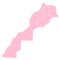 Image 1
 -


- Article(s)
- Regions of Morocco
- Request
- Creation of a blank administrative map of Morocco (like the image 1) but with the format of a location map. Thank you in advance. -- Reda benkhadra (talk) 21:01, 25 August 2017 (UTC)
- @Offnfopt: Thank you for the work done. Is it possible to upload an other SVG map with rivers for geo-location purposes. Cordially --Reda benkhadra (talk) 23:56, 29 August 2017 (UTC)
- Graphist opinion(s)
Second World War animation

- Article(s)
- Second World War
- Request
- this one is a smaller fix-create English version (just change months) and capitalize proper nouns (World War, Europe) in new title, please!… -- Kintetsubuffalo (talk) 23:21, 27 August 2017 (UTC)
- Graphist opinion(s)
Boring, Oregon-- unincorprated community
Article: Boring, Oregon
Request:
Hello, I am looking for someone to make a map similar to this: ![]() with the state of Oregon next to Clackamas County, with the unincorporated community of Boring highlighted within. It is intended to be used in the infobox, similarly to the Ashland, Oregon article. Thank you! --Drown Soda (talk) 23:21, 29 August 2017 (UTC)
with the state of Oregon next to Clackamas County, with the unincorporated community of Boring highlighted within. It is intended to be used in the infobox, similarly to the Ashland, Oregon article. Thank you! --Drown Soda (talk) 23:21, 29 August 2017 (UTC)
- This isn't possible; these maps show the defined boundaries of municipalities or census-designated places, and as Boring is neither one, it doesn't have defined boundaries that can be marked on this map. It would be possible, of course, to place a dot on the map showing its center; would that fit your needs? Nyttend (talk) 00:16, 4 September 2017 (UTC)
Spain as "Permanent Guest" of G20


- Article(s)
- G20
- Request
- Can someone take these maps of the G20 countries and highlight Spain as a "permanent guest" nation, as opposed to the temporary ones highlighted on these maps? Wildboy7 (talk) 05:56, 30 August 2017 (UTC)
- Graphist Opinion(s)
Are you asking for a new color to be introduced to the maps, indicating "permanent guest" status? Do you have a reference showing that this status exists, and that Spain has it? Maproom (talk) 08:49, 30 August 2017 (UTC)
- Response to Graphist Opinion(s)
Here is a source referencing Spain's "permanent guest" status: (https://www.g20.org/Webs/G20/EN/G20/Participants/participants_node.html). And yes, I would like you to put in a new colour on the maps to indicate this status (preferably red or yellow since those are the national colours of Spain). Wildboy7 (talk) 07:08, 31 August 2017 (UTC)
- I see that the source you cite also has a map, which colors Spain the same as other guest nations. I see no need for us to treat it differently. Maproom (talk) 09:46, 31 August 2017 (UTC)
- But the source also specifically mentions that Spain is a permanent guest, which means that it is automatically invited to every G20 meeting. No other country has that status. Other guest countries get invited to a single G20 meeting at a time and that's it. Spain is automatically invited to every G20 meeting without a second thought, which basically is like being a member without it being official. That's the difference between being a temporary guest and a permanent guest (which is what Spain is) at a G20 summit and that's why I believe that this distinction is important enough to note on these maps. Wildboy7 (talk) 17:01, 31 August 2017 (UTC)
A few things wrong with a commonly used Oceania map.
-
 Oceania regions

.png)
![[2]](https://apps.ksbe.edu/enrichment/sites/apps.ksbe.edu.enrichment/files/Oahu.jpg)
![[3]](http://www.kumukahi.org/unit_assets/Oahu_moku_names.jpg)
- Article(s)
- Oceania
- Request
- A few things wrong.
Kiribati is misspelled(now corrected), Nauru is part of Micronesia (not Melanesia) -- - The derivatives of this map also need to be corrected. 8.40.151.110 (talk) 00:33, 31 August 2017 (UTC)
- Graphist opinion(s)
Kinyongia mulyai Rangemap
- Article(s)
- Kinyongia mulyai
- Request
- HI, I would like a species range map for the following chameleon species. The following is a map source from the IUCN(http://maps.iucnredlist.org/map.html?id=75976903) containing spatial data. Thanks. -- Moist towelett (talk) 14:21, 1 September 2017 (UTC)
- Graphist opinion(s)
Polygamy map
At the article polygamy, could you please change Myanmar to dark blue ("Polygamy is illegal and practice criminalized") because they criminalized polygamy in 2015. [6] [7]

![]() Done. Maproom (talk) 20:05, 3 September 2017 (UTC)
Done. Maproom (talk) 20:05, 3 September 2017 (UTC)
Wrong Eastern Province map information on Katete District Page
-
Description of first image
-
Description of second image (if needed)
-
Description of third image (if needed; don't request too many at once, though)
- Article(s)
- [[]]
- Request
- Details of your request go here… -- 164.160.12.38 (talk) 12:09, 7 September 2017 (UTC)
- Graphist opinion(s)
Hello Please check the information contained on the map of Eastern Province of Zambia placed on the Katete District Page reflecting Nyimba where Petauke is supposed to be and vice versa. Your find a correct one on https://upload.wikimedia.org/wikipedia/commons/thumb/8/8e/Zambia_Eastern_Province_Districts.svg/800px-Zambia_Eastern_Province_Districts.svg.png or https://www.google.co.zm/searchq=eastern+province+zambia+map+with+districts&tbm=isch&imgil=GDKxERz3EnqmrM%253A%253BkvxCL6gkUFsprM%253Bhttps%25253A%25252F%25252Fen.wikipedia.org%25252Fwiki%25252FEastern_Province%25252C_Zambia&source=iu&pf=m&fir=GDKxERz3EnqmrM%253A%252CkvxCL6gkUFsprM%252C_&usg=__8yzf8vD_E_7dBh3vcqIzkLL0ysE%3D&biw=1366&bih=638&ved=0ahUKEwjonNCcg5PWAhVBIMAKHRvFB4MQyjcIPw&ei=xzSxWaidCsHAgAabip-YCA#imgrc=GDKxERz3EnqmrM:
Kind regards,
Kelvin Kakanku - Zambia
- If this request is about an error in a specific map, could you please let us know which map, preferably by including it in the gallery above? The article Katete District doesn't mention Nyimba or Petauke. Maproom (talk) 07:34, 8 September 2017 (UTC)