Winnemucca Lake
| Winnemucca Lake | |
|---|---|
| Coordinates | 40°06′40″N 119°20′28″W / 40.111°N 119.341°W |
| Surface elevation | 3,770 ft (1,150 m) |


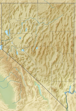
Winnemucca Lake is a dry lake bed in northwest Nevada that features the oldest known petroglyphs in North America. Located astride the border between Washoe and Pershing counties,[1] it was a shallow lake until the 1930s, but was dried when a dam and a road were built that combined to restrict and block water flow. It was formerly designated as a National Wildlife Refuge, but its status as a refuge was removed due to the lack of water.
Winnemucca Lake is home to several
Note: There is another lake, having the same name of "Winnemucca Lake" in California, near the Carson pass (coordinates: 38°40'10.80"N, 119°59'36.59"W, google map link: https://goo.gl/maps/79RHE2cNwEwNC2WB9).
Geography
Winnemucca Lake is a sub-basin within the
History
Winnemucca Lake may have been dry when
Frémont's 1844 map indicates that he traveled to the west of Winnemucca Lake and does not map the Winnemucca Lake valley.[9] The Elko Free Press reports that there was a flood in 1862 that filled the lake to 80 feet (24 m), but Russell states that the level was low in 1862.[10]In 1865, Winnemucca Lake (then known as Mud Lake) was the site of the Battle of Mud Lake where 29 soldiers from the 1st Nevada Volunteer Cavalry Battalion led by Captain Almond B. Wells (and two civilian guides) killed 29 Smoke Creek Indians. At least two of those killed were women, possibly more. Sarah Winnemucca wrote "I had one baby brother killed there. My sister jumped on father's best horse and ran away. As she ran the soldiers ran after her but thanks be to the Good Father in the Spirit land my dear sister got away. This almost killed my poor papa."[11]
The maximum level of the lake was 26 meters (85 ft) in the 1880s[7]
Winnemucca Lake was a shallow
Petroglyphs
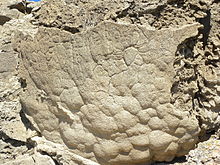
The western end of Winnemucca Lake is home to several boulders carved with
In 2013, a team of researchers from the
Dating of the lowest (newest) carbonate crust yielded a date of 10,200 to 9,800 years ago. The algal formation dating suggested the waterline was sufficiently low from 12,600 to 11,400 years ago. The sedimentary core analysis of Pyramid Lake showed the waterline began to fall about 15,000 years ago, reaching a low approximately 13,300 years ago. At about 13,200 years ago it rose again, and had intermittent low periods thereafter (from 11,300 to 10,500 according to one method, or from 11,500 to 11,100 according to another).
The rocks include both simple petroglyphs such as straight lines and swirls and more complex petroglyphs that resemble trees, flowers, or the veins of a leaf. There also is an intricate diamond pattern on one rock. The smallest are approximately 8 inches (20 cm) in width, while the largest are 3 feet (0.91 m).[18] Grooves are approximately .4 to .8 inches (1.0 to 2.0 cm) deep.[2] The carvings are deeper and larger than those typically found in the Southwestern United States. The meaning of the carvings is unknown.[19] The Connick team suggested the petroglyphs may represent meteorological symbols such as clouds and lightning. Benson's team suggests the Winnemucca Lake petroglyphs share several distinctive features in common with the Long Lake petroglyphs that are not found in more recent petroglyphs.[2]
How the petroglyphs were created is not known. One possibility is that hard volcanic rock was used to chip away at the softer carbonate formations on the boulders.[18]
References
- ^ U.S. Geological Survey Geographic Names Information System: Winnemucca Lake
- ^ .
- ^ Kumiva Peak, Nevada—California, 30x60 Topographic Quadrangle, USGS, 1984.
- ^ Reno, Nevada—California, 30x60 Topographic Quadrangle, USGS, 1980.
- ^ a b Jeremy Pratt (September 1997). Truckee-Carson River Basin Study (PDF) (Report). The Western Water Policy Review Advisory Commission. p. 7. Retrieved 2013-08-21.
- ^ Cassinelli, Dennis (2018-01-11). "Stories of Old Nevada: Fishing Winnemucca Lake". Elko Free Press. Retrieved 2018-10-14.
- ^ a b Hattori, Eugene M.; Tuohy, Donald R. (May 1993). "Prehistoric Human Occupation and Changing Lake Levels at Pyramid and Winnemucca Lakes Nevada". In Benson, Larry V. (ed.). Proceedings of the Workshop "Ongoing Paleoclimactic Studies in the Northern Great Basin". US Geological Survey Circular. No. 1119. p. 32. Retrieved 2018-10-14.
When J. C. Fremont entered the region in 1844, Winnemucca Lake may have been dry
- ^ Report of the exploring expedition to the Rocky Mountains in the year 1842, and to Oregon and North California in the years 1843–44. 1845. p. 216. Retrieved 2018-11-02.
- Frémont, John C. (1845). Map Of An Exploring Expedition To The Rocky Mountains(Map). Retrieved 2018-11-02.
- ^ Russell, Israel Cook (1885). Geological History of Lake Lahontan: A Quaternary Lake of Northwestern Nevada. U.S. Government Printing Office. pp. 63–66.
winnemucca.
- ^ Hopkins, Sarah Winnemucca (1883). Life Among the Piutes: Their Wrongs and Claims. G.P Putnam's Sons. p. 77.
- ^ David James Duncan (1993-10-17). "Troutfishing in the Lake of the Stone Mother: A Sportsman Reflects on the Abuse of a Nevada Lake, Language and the Land". The Los Angeles Times. Retrieved 2013-08-21.
- ^ Pyramid Lake Fishway Replacement Feasibility Study (PDF) (Technical report). U.S. Army Engineer District, Sacramento. November 2000. p. 3. PAP-863. Retrieved 2013-08-21.
- ^ 1 FR 1335
- ^ 5 FR 2680
- ^ U.S. Geological Survey Geographic Names Information System: Winnemucca National Wildlife Refuge (historical)
- ^ 27 FR 5504
- ^ a b c d Ker Than (August 15, 2013). "Oldest North American Rock Art May Be 14,800 Years Old". National Geographic. Archived from the original on August 17, 2013. Retrieved August 16, 2013.
- ^ a b c Zoe Mintz (August 14, 2013). "Oldest Rock Carvings In North America Confirmed, Scientists Have 'No Idea' What Petroglyphs Mean". International Business Times. Retrieved August 15, 2013.

