
Zarasai District Municipality
Zarasai District Municipality
Zarasų rajono savivaldybė | |
|---|---|
Municipality | |
|
UTC+3 (EEST) | |
| Telephone code | 385 |
| Major settlements |
|
| Website | www |
Zarasai District Municipality is one of 60 municipalities in Lithuania. It borders with Latvia and Belarus.
It has significant Russian minority population in Lithuania, with sixth of the population claiming Russian ethnicity.[2]
Local government units
The district has the following localities:
- 2 cities (miestas): Zarasai (capital) and Dusetos
- 3 towns (miestelis): Antalieptė, Salakas, and Turmantas
- about 800 rural settlements (villages and single-family farmsteads)
Biggest population (2001):
- Zarasai – 8365
- Dusetos – 2054
- Salakas – 604
- Dimitriškės – 470
- Antazavė – 461
- Turmantas – 397
- Aviliai – 373
- Antalieptė – 359
- Degučiai – 324
Geography and attractions
30% of the territory is covered by forests (about 65% of those are pine forests), about 10% by lakes. The district has about 300 lakes. The most famous lake is
The district is rich in beautiful nature and could become a tourist destination. However, the geographic location is very inconvenient. Zarasai district municipality is away from major highways. Also, it is quite far away from the capital,
The district has many
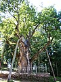
Stelmužė Oak, the oldest tree in Lithuania, grows in the district.
Nature and geography
-

-
-
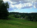 Landscape near Turmantas


References
- ^ "Gyventojai gyvenamosiose vietovese". osp.stat.gov.lt (in Lithuanian).
- ^ "Statistika | Tautinių mažumų departamentas prie Lietuvos Respublikos Vyriausybės". Retrieved 20 May 2023.
